A significant, multi-day, large-scale winter storm is developing which is forecast to bring snow from Texas to New York; some of that snow may be very heavy with accumulations exceeding a foot. Beyond heavy snow, there could also be a crippling ice storm with accumulating ice on trees and power lines expected to create power outages into portions of the southeastern United States. Some strong thunderstorms and heavy rain showers are also possible over portions of Louisiana and southern Mississippi and Alabama where precipitation will remain wet rather than white.
An arctic air mass continues to dominate much of the eastern half of the continental US , especially across Northeast and Midwest, bringing bitterly cold temperatures persisting through much of the week. Freeze Warning are in effect for parts of Georgia into northern Florida, as sub-freezing temperatures will return overnight. As the Arctic cold air mass continues to spread southeastward, expect significantly below normal cold conditions to prevail for much of the central and eastern U.S. Thursday into Friday. Temperatures will be between 15-25 degrees below normal with parts of the Northern Plains and Upper Midwest dropping below 0 degrees. While the eastern half of the country is cold, the western U.S. will be near normal to slightly above normal temperatures over Western U.S. through Friday.
The cold air in place will help set the stage for a multi-state, multi-day, multi-precipitation type winter storm to develop in the coming days.
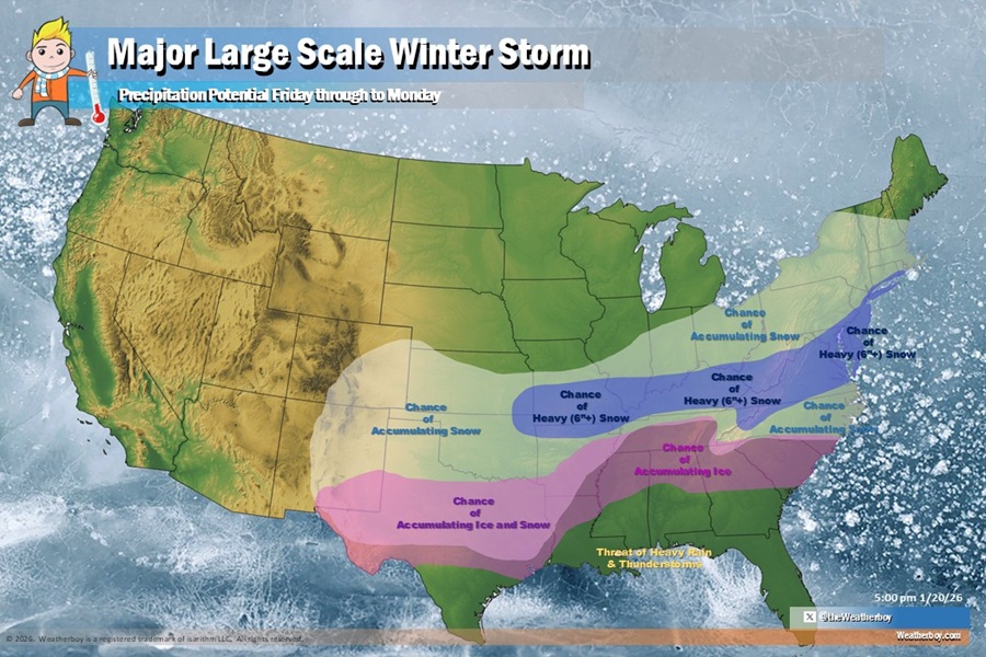
A low pressure system will bring a southern stream storm system across northern Baja California towards the end of the week. With the cyclonic flow, moist air from the Gulf of America will pool and collide with the Arctic air bringing widespread wintry precipitation across Texas to the Southeast later Friday into Saturday. As the system continues to track further north, snow chances will increase across the Ohio Valley, Mid-Atlantic, and Northeast. Snow should push into the northern Mid Atlantic in earnest by later Saturday and Sunday before ending late Sunday night. Snow could linger into southeastern New England on Monday morning before exiting the coast. Below this area of snow, the atmospheric temperature profile will support more ice than other precipitation types. Some of the ice could be significant, glazing roads, trees, and power lines with a dangerous layer of ice and freezing rain. South of the ice zone, heavy rainfall from southern Louisiana east to the south Florida coast is expected. In Florida, the heavy rain will be primarily beneficial, as conditions over this area trends drier for this time of year. There is a slight chance for some isolated flash flooding but a widespread flood event appears unlikely for now.
Right now, it appears the best chances for accumulating snow will stretch from southeastern Colorado and eastern New Mexico across northern Texas, much of Nebraska and Oklahoma, and points east and north into Missouri, Illinois, Ohio, Pennsylvania, New York, southern Vermont and New Hampshire, southernmost Maine, Massachussetts, Rhode Island, Connecticut, New Jersey, Delaware, Maryland, Virginia, much of North Carolina, northern Tennessee, and portions of Arkansas. Within this snow area, it appears the best odds for heavy snowfall currently stretch from southern Missouri east into southern Illinois and Indiana, much of Kentucky, southern West Virginia, and most of Virginia, Maryland, Delaware, and New Jersey. Right now, New York City is on the northern edge of where the heavy snow could be.
South of the snow area will be a wintry mix of snow, sleet, and freezing rain or a mix of sleet and freezing rain that could change to plain snow before ending. The best chance of accumulating ice and snow will be over central Texas; some wintry precipitation may even extend south into the Houston metro area, especially the northern suburbs there. A chance of mainly accumulating ice will also exist over portions of northern Louisiana, Alabama, Georgia, and central Tennessee, as well as much of South Carolina. Here travel may become treacherous if not impossible while a glaze of ice could create widespread electrical failures.
The forecast continues to evolve with more data arriving on meteorologists’ desks and computers every hour. Snowfall amounts will probably be known about 72 to 96 hours before the snow hits.
