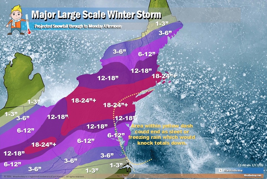
A significant winter storm will impact much of the eastern United States over the next several days; with ample cold air available, a widespread area of more than a foot of snow is expected, including over the heavily populated I-95 corridor. Major metro areas like Philadelphia and New York City could see well over a foot of snow with more than 2 feet not out of the realm of possibilities.
A variety of meteorological ingredients are coming together to create a large-scale, multi-day winter storm. A potent mid-level trough pivoting through southeastern Canada will continue producing lake effect snow showers downwind of the Great Lakes through Friday.
In addition to the lake effect snow, snow showers and snow squalls are likely to develop behind the associated strong surface cold front moving through the Northeast today, with a second round of snow squalls possible on Friday. The first round of snow squalls is likely to develop across Upstate New York this morning before moving through New England, with multiple rounds of snow squalls possible in some areas. The second round is expected Friday afternoon and should move steadily west to east across the region. Snow squalls create an extremely dangerous combination of heavy snow rates and strong, gusty winds, leading to snow-covered roads and near-zero visibility.
The National Weather Service warns, “If you encounter a snow squall while driving and cannot safely exit the roadway, reduce speed, turn on your lights and hazards and avoid slamming on the brakes.”
Meanwhile, dangerously cold and very dry Arctic air will expand into the Northern and Central Plains, Upper Midwest, and Great Lakes today, before spilling out into the Southern Plains, Mississippi Valley and Midwest tonight. This Arctic blast will be accompanied by gusty winds, leading to dangerous wind chills. The coldest wind chills may fall below -50 across the Northern Plains with sub-zero wind chills reaching as far southeast as the Mid-Atlantic, Mid-Mississippi Valley and Southern Plains. These wind chills will pose life-threatening risk of hypothermia and frostbite to exposed skin. Additionally, any power outages caused by the impending
major winter storm could prolong and compound this risk.
“Ensure pets and animals have protection from the cold,” suggests the National Weather Service.
Extreme cold warnings are in effect for much of the Northern Plains and Upper Midwest, while cold weather advisories and extreme cold watches are in effect farther south across the Southern Plains and Lower/Middle Mississippi Valley.
This life-threatening cold air, in conjunction with a surface front to its south and a deep mid-level disturbance moving through northern Mexico will
produce a large, long-duration winter storm tracking from the Southern High Plains and Rockies into the Northeast. Heavy snow, sleet and freezing rain will proliferate across the Southern Rockies/Plains into the Mid-South beginning Friday, spreading eastward to the Mid-Atlantic and New England this weekend. Extremely cold air behind the storm will prolong hazardous travel and infrastructure impacts. Widespread freezing rain and sleet are expected south of the primary snow axis, crippling portions of the Southern Plains and Lower Mississippi Valley on Friday.
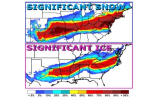
Significant and damaging ice accumulations are likely, with the potential for long-duration power outages, extensive tree damage, and extremely dangerous or impassable travel conditions. Dangerous ice and sleet impacts shift east into parts of the Southeast, Tennessee Valley and Mid-Atlantic this weekend.
During this impactful long-duration winter storm from Saturday through Sunday and into Monday, snowfall rates may exceed one inch
per hour at times, especially on Sunday night.
“Persons should consider delaying all travel from Sunday into Monday,” warns the National Weather Service of those in Winter Storm Watch areas. Winter Storm Watches have been posted for much of the Mid Atlantic, southern New England, and Ohio River Valley. “If travel is absolutely necessary, drive with extreme caution. Make sure your car is winterized and in good working order. Consider taking a winter storm kit along with you, including such items as tire chains, booster cables, flashlight, shovel, blankets and extra clothing. Also take water, a first aid kit, and anything else that would help you survive in case you become stranded.”
When all is said and done by Monday afternoon, a deep blanket of snow will cover many. At this time, it appears there will be widespread 1-2 foot snow amounts across portions of Ohio, West Virginia, Maryland, Virginia, Delaware, New Jersey, Pennsylvania, New York, Connecticut, Rhode Island, and Massachussetts. Some areas could see more than 24″ of snow. Less will fall into northern New England. To the south, sleet and freezing rain will be the primary precipitation type, creating an icy mess.

Depending on the final storm track and how much relatively milder air from the Atlantic moves over land, there could be an area impacted by a change over to sleet, freezing rain, and even plain rain near New York City and Long Island, central and southern New Jersey, Delaware, and the Maryland east coast. The greatest threat of a changeover from sleet/freezing rain to plain rain will likely not be north of Atlantic City, New Jersey. If a changeover does occur, the total snowfall amounts would be cut due to the non-snow precipitation falling. Even so, heavy snow should fall before any changeover occurs here making for a slushy, icy mix which could make snow removal even more difficult.
A foot or more of snow is expected for Philadelphia and New York City. The last time at least 12″ of snow in 1 day in Philadelphia was January 23, 2016 when 19.6″ of snow fell; in that storm, the overall total for Philadelphia was 22.4″. Since 1884, Philadelphia has experienced 9 snow storms with a foot or more of snowfall in January.
