• Skip to primary navigation
  • Skip to main content
  • Skip to primary sidebar

Weatherboy

Weatherboy Weather News, Maps, RADAR, Satellite, and Forecasts.

  • Local
  • Earth Science News
  • RADAR
  • Current Warnings
  • Satellite
  • Current Maps
  • Forecast Maps
  • Video

Slow Moving Storm System to Soak Mid Atlantic

by Weatherboy Team Meteorologist - August 12, 2020

The current GOES-East weather satellite shows clouds associated with a heavy rain making system blossoming over portions of the Mid Atlantic. Image: NOAA


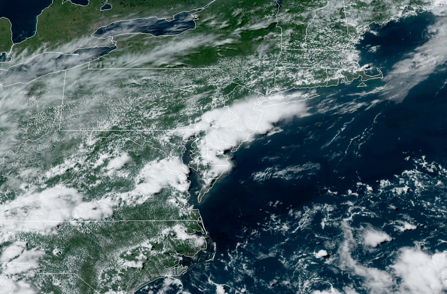
A very slow moving weather system will bring soaking rains to the Mid Atlantic today, with flooding rains becoming more and more likely over a wider area as the afternoon continues. A cold front moving into the region today will very slowly progress south through the end of the week, with several areas of low pressure developing and tracking along it.

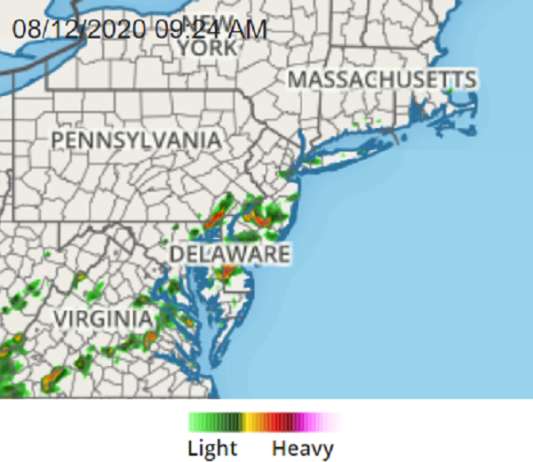
The heaviest area of rain and thunderstorms has formed right along the I-95 corridor near Philadelphia and eastern New Jersey. With a hot, humid, and extremely moist airmass in place, the ingredients have set the stage for heavy rain.  Upper level winds and steering currents are week, which means showers and storms that do form won’t move far. With heavy rain falling over the same places, flash flooding is likely.


Current RADAR shows areas of heavy rain and thunderstorms building. Image: weatherboy.com

With a lack of wind at higher levels of the atmosphere, thunderstorms that blossom probably won’t produce tornadoes. However, as storms grow taller in the weak-sheer environment, they could create severe downbursts of damaging winds in isolated areas.

Beyond the threat of downbursts, heavy rainfall and flash flooding remain the biggest concerns. The National Weather Service is warning people to “turn around, don’t drown; never drive through flood waters” as the threat of flooding increases under the heavy rain area.

Primary Sidebar

Sponsored Ad

Search

Latest News

  • Preliminary NTSB Report Shows Something other than Turbulence Killed Passenger on New England Flight
  • SEVERE Geomagnetic Storm Alert Issued; Massive Aurora On Display in North America
  • World’s Largest Volcano Quakes; No Tsunami Threat Around Hawaii
  • Impacts from Geomagnetic Storm Expected Thursday through Saturday; Watch Issued
  • Three Quakes Rattle Mid Atlantic Ridge; No East Coast Tsunami Threat
  • Spring 2023 Arrives Today
  • Incident Meteorologists Provide Additional Support at Special All-Hazard Events
  • Unseasonably Cold Air Surges South and East Triggering Warnings
About | Careers | Contact | Contests
Terms | Privacy | Ad Choices
Weatherboy is a (R) Registered Trademark of isarithm LLC, All Rights Reserved.
All content herein is Copyright by Isarithm LLC 1997-2022