• Skip to primary navigation
  • Skip to main content
  • Skip to primary sidebar

Weatherboy

Weatherboy Weather News, Maps, RADAR, Satellite, and Forecasts.

  • Local
  • Earth Science News
  • RADAR
  • Current Warnings
  • Satellite
  • Current Maps
  • Forecast Maps
  • Video

Soaking Showers & Storms Expected

by Weatherboy Team Meteorologist - July 16, 2018

A high-resolution, short-duration computer forecast model shows how a line of showers and storms is forecast to build and move east through the northeast tomorrow. Image: TropicalTidbits.com


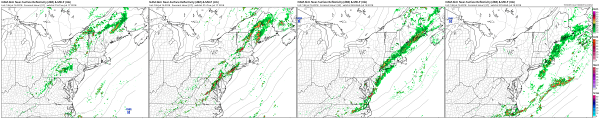
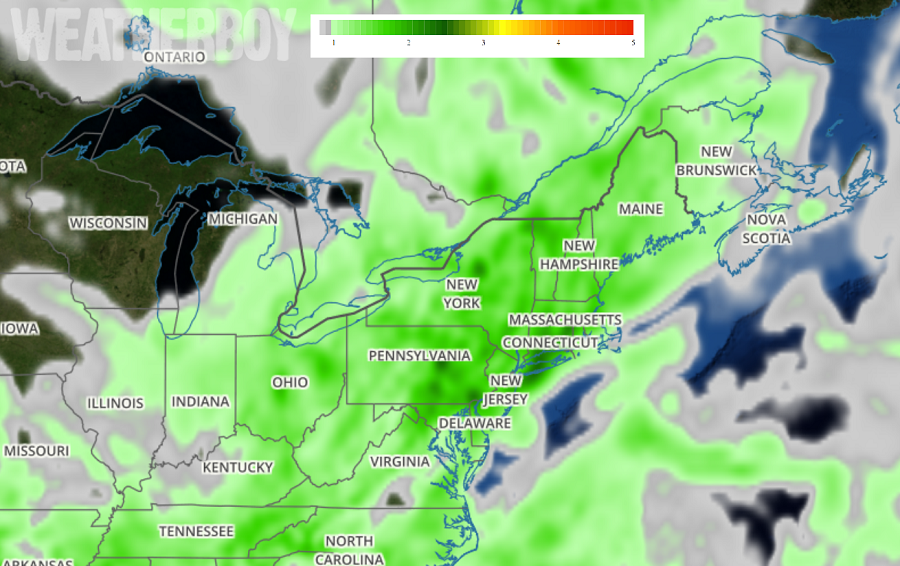
Tuesday will feature some potent thunderstorms and soaking heavy rain showers in the northeast that could create flooding concerns. A low pressure system will moves across Ontario and Quebec tonight and Tuesday. An associated strong cold front will cross the I-95 corridor Tuesday afternoon and Tuesday night, setting off a line of showers and storms. High pressure from the Great Lakes will follow for Wednesday but not before several inches of rain fall on some and remain over our area into Friday night.  Another period of heavy rain could return next weekend as a series of disturbances push into the Mid Atlantic then.

Soaking rain is possible along the I-95 corridor, especially during the PM hours on Tuesday. Image: Weatherboy.com

While Tuesday may start off with some showers or storms, the main act will occur during the PM hours. An amplifying upper-level trough will approach  from the west as a surface cold front arrives.  With more clouds and humidity tomorrow, Tuesday will be slightly cooler than today’s readings in the Mid Atlantic and Northeast.  It will be quite humid and the National Weather Service believes that the atmosphere will be capable of raining 2-2.25″ of rain during the PM hours. With plenty of moisture and instability available, severe storms are possible. The greatest threat of severe thunderstorms will be over New England; however, storms with frequent lightning are possible into the Carolinas.  Beyond frequent lightning in all of these storms, the threat of some wind damage is the greatest severe weather threat from these storms.


With isolated pockets of exceptionally heavy rain expected, there could be flash flood concerns. The National Weather Service cautions residents, “Turn around, don’t drown! Never drive through flood waters.”

Cooler and drier air will arrive on Wednesday as a much more comfortable air mass returns for the balance of the work week. However, eyes will be on another low pressure system that could bring another round of soaking rains to the northeast in time for the weekend.

Primary Sidebar

Sponsored Ad

Search

Latest News

  • White Christmas December 2025?
  • Final Supermoon of 2025 Arrives
  • Geomagnetic Storm WARNING Issued for Earth; G3-STRONG Conditions Expected
  • Morning Shaking in Cooter Reminds of NMSZ Danger of Big Earthquakes Near Missouri
  • Two Earthquakes Strike New York Minutes Apart
  • Winter Storm to Dump A Foot or More of Snow in Northeast
  • Weak Earthquakes Rattle North Carolina and Tennessee Today
  • FAA Declares Emergency Order; Grounds Jets From Multiple Airlines due to Geomagnetic Storm Threat
About | Careers | Contact | Contests
Terms | Privacy | Ad Choices
Weatherboy is a (R) Registered Trademark of isarithm LLC, All Rights Reserved.
All content herein is Copyright by Isarithm LLC 1997-2022

Insert/edit link

Enter the destination URL

Or link to existing content

    No search term specified. Showing recent items. Search or use up and down arrow keys to select an item.