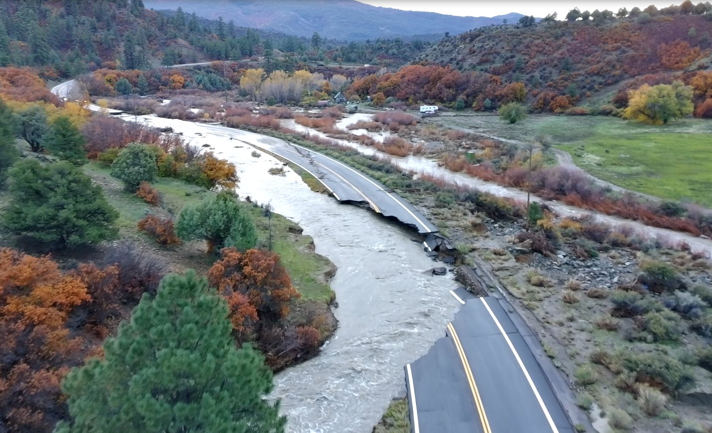
Image: Colorado Department of Transportation
Rivers across southwest Colorado were falling Tuesday after a second round of flooding in less than two weeks sent the San Juan River to its highest level in more than a century, isolated Pagosa Springs, destroyed part of a key highway bridge and pushed the Animas River through Durango at about 50 times its normal flow.
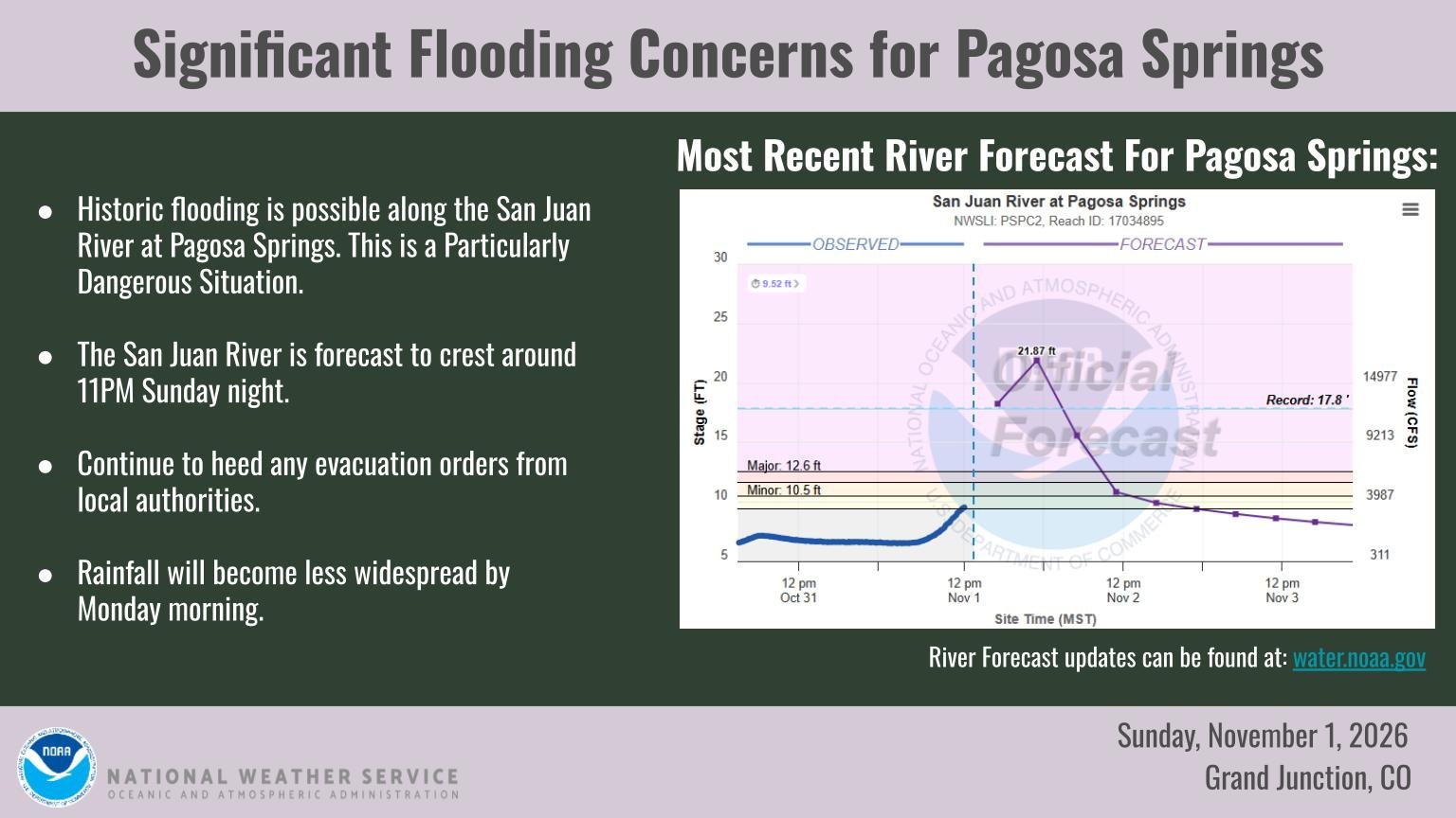
The San Juan River crested at 16.81 feet at Pagosa Springs around 8 p.m. Sunday, about a foot below the record of 17.8 feet set in 1911, The Colorado Sun and the Pagosa Springs SUN reported. Forecasters had warned that the river could reach 21.84 feet, said Brooke Scholtens, a meteorologist with the National Weather Service in Grand Junction. Colorado Public Radio reported the crest was the highest since 1911.
More than 1,000 homes in Archuleta County were under mandatory evacuation orders, Sheriff Mike Le Roux said. Downtown Pagosa Springs remained under evacuation orders, and cellphone service was down in the area.
So much for turn around, don’t drown!
— the Weatherboy (@theWeatherboy) November 3, 2026
Second Storm on Soaked Ground
The weekend storm hit a region still recovering from historic flooding Oct. 22-25. That earlier flood prompted Gov. Jared Polis to issue a verbal disaster declaration Oct. 23 and to request a major federal disaster declaration Oct. 31, The Colorado Sun reported.
Charles Balke, the incident commander, said the ground was already saturated when the new rain arrived, leaving little room for the water to soak in.
The Colorado Division of Homeland Security and Emergency Management said in a Nov. 2 update that the State Emergency Operations Center was at a Level 1 activation, its highest, and that 12 counties had been affected.
Pagosa Springs Largely Isolated
The Colorado Department of Transportation closed the U.S. 160 First Street Bridge in Pagosa Springs because of erosion near the town’s museum. With U.S. 160 closed on both sides of town, Pagosa Springs was largely cut off, with one rural highway still open south toward New Mexico, Colorado Public Radio reported.
About 22 miles west of town, the U.S. 160 bridge over the Piedra River “suffered severe damage,” and “a section is gone,” said Vicki Shaffer, a spokeswoman for the Colorado incident management team. CDOT described the damage as a bridge failure and said a workable replacement could be in place in a week or two.
Lisa Schwantes, a CDOT spokeswoman, said the highway is a lifeline for the region. “This is how we get our freight, our supplies, our medical needs,” Schwantes said.
CDOT also closed U.S. 550 near Hermosa, U.S. 285 north of Monte Vista, and state highways 112, 17 and 151. Wolf Creek Ski Area temporarily closed.
The damage adds to repairs already underway from October’s flood. CDOT said Oct. 30 that the Federal Highway Administration had approved $6.5 million in quick-release emergency funds to begin repairs on U.S. 160, U.S. 550 and Colorado 151. The agency estimated about $65 million in damage to federal-aid roadways from the October flood and called that figure preliminary because high water had limited full inspections of bridges.
Animas River Surges Through Durango
In Durango, the Animas River rose from 1,750 cubic feet per second at 11:45 p.m. Saturday to 13,000 cubic feet per second by 10:15 a.m. Monday, topping its Oct. 23 peak of 11,200, according to U.S. Geological Survey gauge readings. Colorado Public Radio reported the flow was about 50 times normal.
La Plata County Sheriff Sean Smith closed the Animas River to all watercraft.
“There is sewage and other contaminants in the water that will make people very sick,” county spokeswoman Emily Spencer said.
Durango City Manager José Madrigal signed an emergency disaster declaration. City spokesman Tom Sluis said damage to city infrastructure appeared limited.
“We’re not seeing any obvious damage to city infrastructure at this point,” Sluis said.
Tracks of the Durango & Silverton Narrow Gauge Railroad were damaged, the Herald reported.
The weather service said Tuesday morning that the Animas River at Cedar Hill, near the New Mexico state line, was near its major flood stage of 12.5 feet, well above its flood stage of 10.5 feet. Forecasters expected the river to fall below flood stage by late Tuesday afternoon.
Evacuations Across the Region
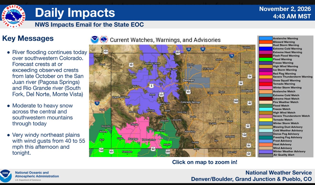
The flooding stretched well beyond Archuleta and La Plata counties. In Rio Grande and Mineral counties, evacuations affected 2,773 people in South Fork, Del Norte and Monte Vista, according to the state emergency operations center. Evacuations were also ordered in parts of Conejos County, including Manassa.
In Mancos, John Bradford, manager of the Sun Dog Gallery, said, “We were really lucky.”
National Guard, Federal Teams Respond
The Colorado National Guard rescued more than 50 people and more than 20 dogs, the state said. Its Task Force Aviation, with about 20 members, a UH-60 Black Hawk and an LUH-72 Lakota helicopter, was staged at Pagosa Springs. About 80 ground personnel and 30 vehicles also supported the response.
FEMA’s Colorado Task Force 1 urban search and rescue team was deployed.
Dam safety engineers with the Colorado Division of Water Resources were inspecting dams daily in the flooded area, the state Office of Emergency Management said.
Residents who need help with cleanup can call the Crisis Cleanup hotline at 970-283-7325.
Voting Changes in Archuleta County
Election officials in Archuleta County adjusted Election Day voting because of the flooding. A mobile ballot drop box was set up at 10 Solomon Drive, and the county’s Election Day voter service and polling center was moved to the county courthouse at 109 Harman Park Drive, the Pagosa Springs SUN reported.
Outlook: Drier, Then a Quick Storm
Forecasters said the worst was over for now. Weather service meteorologist Gillian Harrison said rivers were expected to keep dropping.
“We have many of our rivers of concern in southwest Colorado … decreasing gradually over the next few days,” Harrison said.
The weather service in Grand Junction said calmer conditions were settling in Tuesday, though fog could develop in valleys around sunrise.
A quick-hitting system Wednesday was expected to bring rain to lower valleys, a rain-snow mix to mountain valleys and snow to the passes and higher elevations. Forecasters said the storm was not expected to cause more flooding.
Officials urged residents to stay out of floodwaters and off closed roads, and to follow evacuation orders until local authorities lift them.
