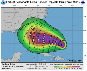
Time is running out for people to prepare ahead of the expected impact of Hurricane Dorian, which could be a powerful Category 4 hurricane at landfall. In the latest forecast from the National Hurricane Center (NHC), Dorian is projected to plow through the northern Bahamas on Sunday and Monday, prompting Hurricane Watches to be issued there. Then late Monday into Tuesday, Dorian is projected to strike the Florida East Coast as at least a Category 4 hurricane.
The most recent Category 4 storm to strike Florida was Irma in 2017. The most recent Category 4 storm to strike Florida’s east coast was Hurricane King in 1950; the most recent Category 5 storm was Andrew in 1992. If the current forecast comes to fruition, Dorian will be the strongest hurricane on record to strike the area it is and would rank as a top 10 hurricane for the sunshine state.

The National Hurricane Center (NHC) is warning that life-threatening storm surge and devastating hurricane-force winds are likely in portions of the northwestern Bahamas, where a hurricane watch is in effect. Residents should execute their hurricane plan immediately if they have not yet done so and listen to advice given by local emergency officials.
Life-threatening storm surge and devastating hurricane-force winds are likely along portions of the Florida east coast by early next week, but according to the NHC, it is too soon to determine where the highest storm surge and winds will occur. It is possible sustained winds will be at or above 140mph in portions of the Florida east coast; it is also possible storm surge will be 10-15′ or higher in the impact zone. Residents should have their hurricane plan in place, know if they are in a hurricane evacuation zone, and listen to advice given by local emergency officials.
The National Hurricane Center is also warning that a prolonged period of storm surge, high winds and rainfall is likely in portions of Florida into next week, including the possibility of hurricane-force winds over inland portions of the Florida peninsula. Unlike quick hitters of previous storms, this storm is a slow mover; it is expected to creep along at 5 mph on landfall day, bringing destructive conditions to a large area for a long, protracted period.
Florida won’t be the only state impacted by Dorian. Heavy rains are expected over portions of the Bahamas, Florida, and elsewhere in the southeastern United States this weekend into the middle of next week. It is still too soon to tell what, if any, direct or indirect impacts will occur on the rest of the southeast and Mid Atlantic coast next week as Dorian moves on.
It is likely the major amusement attractions in Florida will close as Dorian arrives. The NASA Kennedy Space Center has already announced they’re closing.On Saturday, August 31, Kennedy Space Center Visitor Complex will be open during regular operating hours of 9 a.m. to 6 p.m. Kennedy Space Center Bus Tours to the Apollo/Saturn V Center will be available until 2:30 p.m. Special Interest Tours will not be available. Then the park will be closed for September 1 and September 2 and could be closed longer depending on the track and impacts from the hurricane.