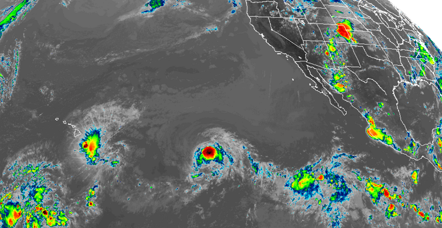
After a brief period of busy action, it appears activity in both the Central Pacific and Atlantic hurricane basins are tapering off with overall tropical cyclone activity fizzling. In the Atlantic basin, there are currently no named tropical cyclones while the Pacific has two: Tropical Storm Erick and Tropical Storm Flossie. There are low odds that any others will form over the next 5 days.
Right now, Tropical Storm Erick is bringing gusty winds and occasionally heavy rain showers to portions of Hawaii, with most rain focused on the Big Island of Hawaii. As of the latest update from the Central Pacific Hurricane Center in Honolulu, Hawaii, the center of Tropical Storm Erick was located near latitude 16.4 North, longitude 155.8 West. Erick is moving toward the west-northwest near 13 mph and this motion is expected to continue over the next couple of days. A turn toward the northwest at a slower is expected on Sunday. On the current forecast track, the center of Erick will pass well south of Hawaii by at least 175 miles. Maximum sustained winds in the system’s core are near 65 mph with higher gusts. While some gusts may reach tropical storm strength on Hawaii Island, sustained winds above storm strength will remain off-shore. Rapid weakening is forecast to continue for the next 6-12 hours with gradual weakening into the weekend. Erick is expected to become a tropical depression by Sunday, and a post-tropical remnant low on Monday. The estimated minimum central pressure is 996 mb or 29.42 inches.
Currently, a strong southwesterly sheer is shredding Erick apart, blowing storm tops well to the north and east away from the center of circulation. While there’s poor representation of the storm on satellite, it does have an abundance of moisture to work with. Because of this, isolated flash flooding could occur on Hawaii even with the storm center so far away and losing strength. Localized amounts of 4-8″ are possible through Saturday morning.
NOAA’s Central Pacific Hurricane Center (CPHC) Director, Chris Brenchley, described to us today how his Honolulu team coordinates, collaborates, & even swaps staff with Miami-based National Hurricane Center (NHC) to keep America #HurricaneStrong?@NWSHonolulu pic.twitter.com/W1WM2EeXeC
— the Weatherboy (@theWeatherboy) May 23, 2019
To Erick’s east is Tropical Storm Flossie. Flossie is located near latitude 16.8 North, longitude 136.4 West. Because Flossie hasn’t crossed 140 West yet, the National Hurricane Center in Miami, Florida is issuing advisories for it. When Flossie crosses 140 West later today, the Central Pacific Hurricane Center will issue advisories for the storm. For now, Flossie is moving toward the west-northwest near 18mph and this general heading with some decrease in forward speed is expected through late Sunday. Maximum sustained winds are near 70 mph, just below hurricane strength, with higher gusts. Gradual weakening is forecast to begin on Friday and continue through the weekend. Tropical-storm-force winds extend outward up to 140 miles from the center. The estimated minimum central pressure is 993 mb or 29.33 inches.
Eventually, a trough of low pressure will pull Erick northward in the coming days. It is becoming likely that same trough will also lift Flossie north prior to it nearing Hawaii. If this trend holds true, Hawaii may see little to no impacts from this storm next week. Should Flossie not take a north turn, Hawaii could be hit head-on by the system. Even if Flossie misses Hawaii, it should generate rough and high surf on Hawaii’s east facing shores into the start of the new week.
Beyond Erick and Flossie, there’s only 2 other areas being monitored for potential development; one in the Atlantic and one in the Pacific. Neither has a high chance of become a tropical cyclone at this time.
In the Atlantic, an elongated low pressure system located over the central tropical Atlantic Ocean was located about midway between the Cabo Verde Islands and the Lesser Antilles. Right now, it is producing limited shower and thunderstorm activity. According to the National Hurricane Center, some slow development of this system is possible, and a tropical depression could form well east of the Lesser Antilles by early next week while the low moves west-northwestward at 10 to 15 mph. Upper-level winds are forecast to become less conducive for development by Tuesday and Wednesday as the system approaches the Leeward Islands. Because of the hostile environment, the National Hurricane Center believes there’s only a 20% chance of tropical cyclone formation here over the next 48 hours and a 50-50 shot of storm formation over the next 5 days.
Odds are even lower that the disturbance in the Pacific will form into something. Showers and thunderstorms associated with a broad area of low pressure located almost a thousand miles south-southwest of the southern tip of the Baja California peninsula remain disorganized. According to the National Weather Service, upper-level winds are expected to be marginally conducive for development only during the next day or two while the low moves west-northwestward at about 10 mph. As such, they peg odds of tropical cyclone formation at only 20% for both the next 48 hours and the next 5 days.
Outside of these areas, no tropical cyclone formation is expected in the Central or Eastern Pacific Basin nor the Atlantic Basin over the next 5 days. The Hurricane Season continues through to the end of November for these basins.