
A tropical cyclone has developed near Hawaii and is forecast to remain far enough away to not directly impact the Aloha State. According to the Central Pacific Hurricane Center and the National Hurricane Center, Tropical Depression One-C has formed, making it the first tropical cyclone to form in the Central Pacific Hurricane Basin this season. Like the Atlantic, the Central Pacific Hurricane Season runs from June 1 through to November 30.
According to the National Hurricane Center, the system continues to become better organized with deep convection in curved banding generally to the west of the center. Recent imagery shows that convection has been developing the last few hours near the low-level center, with some increased curvature.
While it’s getting better organized, it is still far from Hawaii and is likely to travel south of the state in the coming days. As of the latest official advisory, the system was located at 11.0N 147.4W which puts it about 995 miles southeast of Honolulu, Hawaii on the island of Oahu. While the minimum central pressure is at 1008 mb or 29.77″, the maximum sustained winds are at 35 mph.
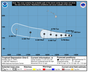
The depression is moving toward the west near 12 mph and the National Hurricane Center expects this motion to continue for the next few days. On the forecast track, the system is expected to stay well south of the Hawaiian Islands. Gradual strengthening is forecast during the next couple of days and the system should become a named tropical storm within the next 12-24 hours.
Beyond 48 hours, though, a gradual weakening trend should begin as the system moves over slightly cooler sea surface temperatures, a drier airmass, and vertical wind shear is expected to increase. The gradual weakening trend will cause the system to become a remnant low before the end of the new week, potentially even opening into a trough.
With the storm expected to pass well south of the State of Hawaii this week, there shouldn’t be much of any interaction with the trade winds over Hawaii nor the typical shower activity that happens from those trades.
This storm system will also not provide any relief to the extensive drought that is occurring throughout the state. All islands in Hawaii are reporting some degree of drought, with the Big Island of Hawaii having extreme drought conditions now over the north slope of Mauna Kea.
