• Skip to primary navigation
  • Skip to main content
  • Skip to primary sidebar

Weatherboy

Weatherboy Weather News, Maps, RADAR, Satellite, and Forecasts.

  • Local
  • Earth Science News
  • RADAR
  • Current Warnings
  • Satellite
  • Current Maps
  • Forecast Maps
  • Video

Tropical Cyclone Formation Likely in the Atlantic

by Weatherboy Team Meteorologist - July 4, 2018

The latest Tropical Outlook from the National Hurricane Center highlights an area in red where it is likely a tropical cyclone will form and move into. Image: NHC


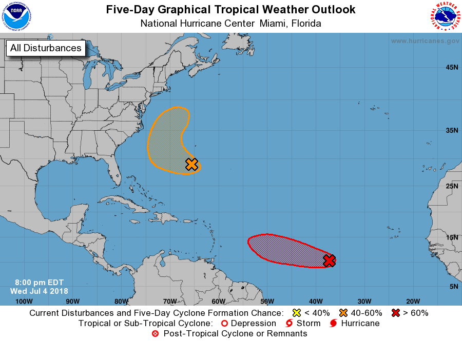
The National Hurricane Center (NHC) now believes there’s a high chance that a disturbance in the Atlantic will become a tropical cyclone in the coming days. This area is one of two the National Hurricane Center began tracking yesterday for potential development.

Latest satellite map shows the areas in concern in the Atlantic, with the system in the central Atlantic showing the most impressive satellite signature of the two. Image: NOAA

The most robust system is in the central Atlantic. Shower activity associated with a small area of low pressure and a tropical wave located about 1000 miles west-southwest of the Cabo Verde Islands continues to become better organized, according to the NHC.  A tropical depression is likely to form during the next day or two while the system moves westward to west-northwestward at 15 to 20 mph over the tropical Atlantic Ocean. By the weekend, however, upper-level winds are expected to become less conducive for development when the system approaches the Lesser Antilles. If the system is able to increase strength to tropical storm status prior to entering that more hostile environment, it would be named Tropical Storm Beryl. In their latest Tropical Outlook, the NHC believes there’s a 70% chance that this system will become a tropical cyclone within the next 48 hours.


The second system is closer to the U.S. East Coast but has a less chance of development than the first. Disorganized showers and thunderstorms located a few hundred miles to the south and southwest of Bermuda are associated with a weak trough of low pressure. According to the NHC, environmental conditions appear conducive for some development of this system, and a tropical depression could form before the end of the week while the system moves west-northwestward and then northward between Bermuda and the east coast of the United States. The disturbance is then forecast to interact with a frontal system on Sunday, which would limit any additional development and likely prevent any direct impacts to the U.S. coast. The NHC believes there’s a 40% chance of tropical cyclone formation in the next 48 hours and 50% over the next five days.

Primary Sidebar

Sponsored Ad

Search

Latest News

  • Additional Snow Expected Over Northeast from Coastal Storm
  • Southeast Snow Likely Across Portions of Florida, Alabama, and Georgia on Sunday
  • Two Earthquakes Strike Alabama Northwest of Birmingham
  • Accumulating Snow Likely For I-95 Corridor; 3″+ Expected for Philly & New York City
  • Weak Earthquake Strikes Knoxville, Tennessee
  • Warnings Issued as Florida Freeze Approaches
  • Snow Possible in Florida This Weekend
  • Fired TV Weatherman Becomes Political Firestorm
About | Careers | Contact | Contests
Terms | Privacy | Ad Choices
Weatherboy is a (R) Registered Trademark of isarithm LLC, All Rights Reserved.
All content herein is Copyright by Isarithm LLC 1997-2022

Insert/edit link

Enter the destination URL

Or link to existing content

    No search term specified. Showing recent items. Search or use up and down arrow keys to select an item.