
After a quiet traditional peak period of the Atlantic Hurricane Season, things seem to be getting a little more busy: the National Hurricane Center has now identified two areas in the Atlantic Hurricane Basin with the potential to develop into tropical cyclones over the next week, with one likely to become a Tropical Storm soon.
Showers and thunderstorms associated with an elongated area of low pressure located about midway between the Windward Islands and the Cabo Verde Islands have become better organized since yesterday according to the National Hurricane Center (NHC.) They say that environmental conditions are conducive for additional development, and a tropical depression or storm is likely to form in the next day or two as the system moves west-northwestward or northwestward at 10 to 15 mph over the central tropical Atlantic. For now, the National Hurricane Center says there’s a very high 90% chance of tropical cyclone formation over the next 48 hours.
Beyond becoming a tropical depression, forecast models call for the system to grow into a tropical storm. Once that happens it would be given the next name from the list of Atlantic storms which would be Gabrielle.
The National Hurricane Center is also tracking a second system. A tropical wave just offshore of the west coast of Africa is producing an area of disorganized showers and thunderstorms. The NHC says that some slow development of this system is possible towards the latter part of this week as it moves westward at 15 to 20 mph, moving from the eastern to central portion of the tropical Atlantic. Right now, the NHC says development is unlikely within the next 48 hours and only 20% over the next 7 days.
Elsewhere there are no areas of concern being tracked by the NHC in the Atlantic Hurricane Basin.
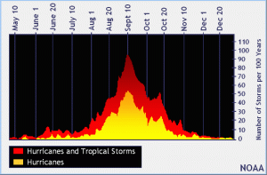
The 2025 Atlantic Hurricane Season runs through to November 30.
