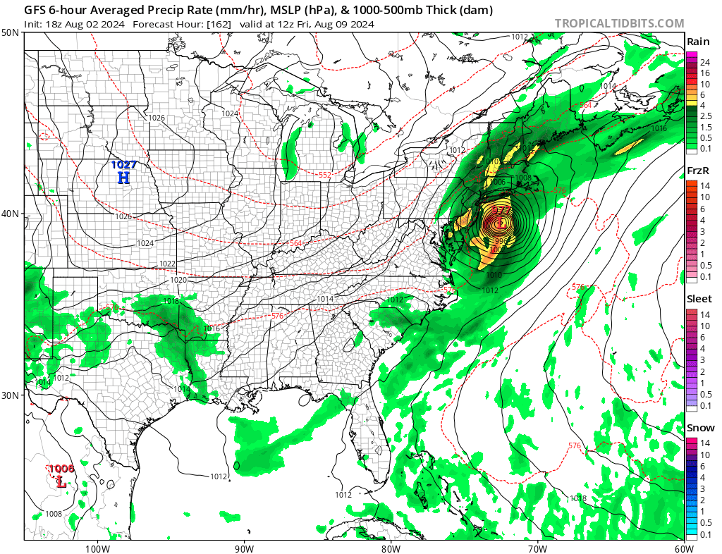
A tropical storm or hurricane could soon impact portions of Florida and the U.S. East Coast in the coming days, prompting the National Hurricane Center (NHC) to issue watches for a potential tropical cyclone. Known simply as “Potential Tropical Cyclone #4″ for now, a disturbance approaching the southeast United States is forecast to become better organized and gather strength. The system is likely to become Tropical Storm Debby over time and some computer forecast guidance suggests it could be a hurricane along the East Coast early next week.
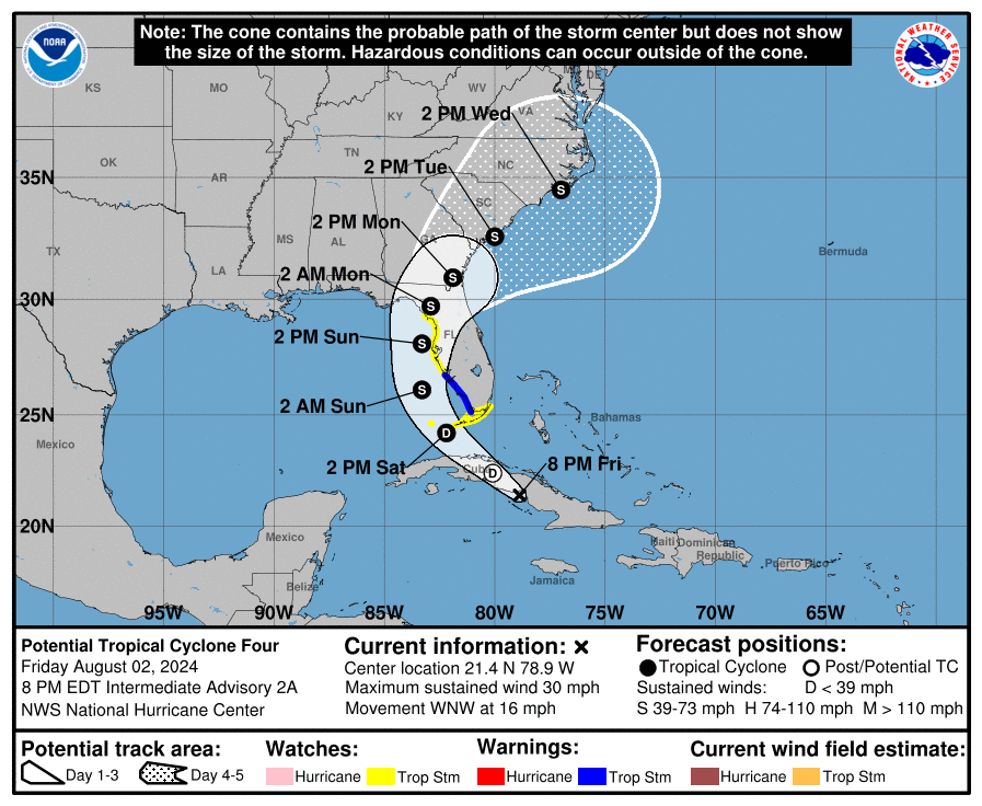
Right now, the system is about 285 miles southeast of Key West, Florida with maximum sustained winds of 30 mph. The storm is moving west-northwest at 16 mph while the minimum central pressure is 1010 mb or 29.82”.
Right now, a Tropical Storm Warning is in effect for the west coast of the Florida peninsula from East Cape Sable to Boca Grande and a Tropical Storm Watch is in effect for the Florida Keys south of the Card Sound Bridge including the Dry Tortugas, the southern coast of the Florida peninsula east of East Cape Sable to the Card Sound Bridge, and for the west coast of the Florida peninsula north of Boca Grande to the mouth of the Suwannee River. A Tropical Storm Warning means that tropical storm conditions are expected somewhere within the warning area within 36 hours. A Tropical Storm Watch means that tropical storm conditions are possible within the watch area, generally within 48 hours.
A Storm Surge Watch is also in effect for Bonita Beach northward to the mouth of the Suwannee River, including Tampa Bay and Charlotte Harbor. A Storm Surge Watch means there is a possibility of life-threatening inundation, from rising water moving inland from the coastline during the next 48 hours.
“Interests elsewhere in the Florida Peninsula and the southeastern coast of the United States should monitor the progress of this system. Additional warnings and watches may be required for a portion of this area tonight and Saturday,” the National Hurricane Center warns.

While the system is moving toward the west-northwest near 16 mph now, a turn toward the northwest at a slower forward speed is expected tonight or Saturday, followed by a turn toward the north on Sunday. On the forecast track, the disturbance is expected to move over Cuba tonight, cross the Straits of Florida into the southeastern Gulf of Mexico on Saturday, and then move near or over the west coast of Florida Saturday night through Sunday night.
Maximum sustained winds are near 30 mph with higher gusts for now, but the NHC expects this system to develop into a tropical depression tonight or on Saturday while over Cuba or the Straits of Florida, followed by intensification into a tropical storm over the eastern Gulf of Mexico by Saturday night. Once it reaches tropical storm strength, it will be named Debby.
The National Hurricane Center says there is now a 90% chance the system will develop into a full fledged tropical cyclone. Numerous hazards are expected in the U.S., with the first impacts due in Florida. Flooding rains, heavy winds, storm surge, and tornadoes are all possible.
Tropical storm conditions are expected in the warning area late Saturday and Saturday night. Tropical storm conditions are possible in the watch area in the Florida Keys and the southern Florida peninsula by Saturday or Saturday night. Tropical storm conditions are possible in the watch area along the Florida west coast Saturday night or Sunday.
The combination of storm surge and tide will cause normally dry areas near the coast to be flooded by rising waters
moving inland from the shoreline. The water could reach 2-4 feet from Bonita Beach to the Suwannee River, for Tampa Bay, and the Charlotte Harbor if the peak surge occurs at the time of high tide.
This tropical system is expected to produce rainfall totals of 4-8″, with maximum rainfall totals up to a foot across portions of Florida and along the Southeast U.S. coast this weekend through Wednesday morning. This rainfall may result in areas of flash and urban flooding, with isolated river flooding possible.
A tornado or two is possible across the Florida Keys and the western Florida Peninsula Saturday night through Sunday morning.
There remains many questions where this storm will head beyond Florida. A turn toward the northwest and north is expected during the next couple of days as the system moves into a break in the subtropical ridge caused by a mid-latitude trough over the Ohio Valley. According to the NHC, this should be followed by recurvature into the westerlies after 48-60 hours.. On the forecast track, the system is expected to move into the Straits of Florida and the southeastern Gulf of Mexico on Saturday, followed by a motion near the west coast of Florida Saturday night and Sunday. After that time, the system should cross the northern Florida peninsula and move over the Atlantic near or offshore of the southeastern coast of the United States.
The NHC cautions that small changes in the track could cause large differences in potential landfalls and which land areas receive the strongest impacts.
The two biggest uncertainties in the intensity forecast are how long the system will remain offshore of Florida and how long it will take to consolidate. The system is likely to weaken as it crosses Florida, with re-intensification likely over the Atlantic after 72 hours.
For now, the NHC has these four key messages:
1. Heavy rainfall may result in flash and urban flooding across portions of Florida and the coastal areas of the Southeast this weekend through Wednesday morning. Isolated river flooding will also be possible.
2. Tropical storm conditions are expected Saturday night within the Tropical Storm Warning area in southwest Florida from East Cape Sable to Boca Grande. Tropical storm conditions are possible in the Florida Keys on Saturday and along the Florida west coast north of Boca Grande to Suwannee River Saturday night and Sunday where a Tropical Storm Watch is in effect.
3. There is a possibility of life-threatening inundation from storm surge along portions of the west coast of Florida from Bonita Beach to Suwannee River, including Tampa Bay and Charlotte Harbor, where a Storm Surge Watch is in effect.
4. Impacts from storm surge, strong winds, and heavy rains are possible elsewhere in Florida and along the southeast coast of the United States from Georgia to North Carolina through the middle of next week, and interests in those areas should continue to monitor the progress of this system. Additional watches and warnings will likely be required later tonight and on Saturday.