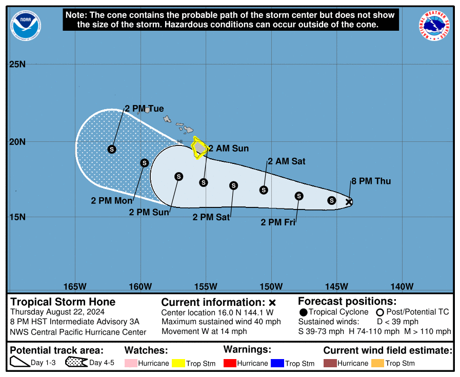
The Central Pacific Hurricane Center (CPHC) in Honolulu on the island of Oahu in Hawaii has issued a Tropical Storm Watch for the Big Island of Hawaii, the largest and easternmost county of the island chain. A Tropical Storm Watch means that tropical storm conditions are possible within the watch area, generally within 48 hours. Tropical Storm Hone is expected to bring impacts to the Big Island and the rest of the state beginning this weekend.
As of the latest advisory from the CPHC, Hone was located near latitude 16.0 North, longitude 144.1 West. Hone is moving toward the west near 14 mph and this motion is expected to continue over the next few days. On the forecast track, the center of Hone is expected to pass near or south of the Big Island Saturday night and Sunday.
Hone is a weak tropical storm with maximum sustained winds of 40 mph with higher gusts. However, the CPHC says some strengthening is forecast during the next couple of days. While Hone will likely become a stronger tropical storm, it is not expected to reach hurricane status while it is around Hawaii.

Tropical storm wind conditions are possible in the watch area later Saturday into Sunday. Winds are expected to be strongest where they blow downslope from higher terrain, over headlands, and through passes. On the current forecast track for Hone, winds will strengthen through the weekend across the state as the pressure gradient increases. The strongest gusts, which could become locally damaging, given this storm track would typically be expected around South Point/Ka Lae, as well as downslope from Mauna Kea, Mauna Loa, the Kohala Mountains, and the Humuula Saddle.
Hone is expected to produce storm total rainfall of 4-8″ over mainly windward and southeast facing slopes of the Big Island, with locally higher amounts. Rainfall totals of 2-4″ inches will be possible over portions of the smaller islands, mainly windward. Far less, if any, will fall on leeward portions of the Big Island.
Swells generated by Tropical Storm Hone are expected to begin reaching the Hawaiian Islands over the weekend. These swells are likely to cause life-threatening surf and rip currents.
Ahead of Hone’s arrival, drier air is expected to move across the western end of the state ahead of Hone on Saturday; as a result, it’ll be a dry and windy day for those areas.
Dry windy conditions on leeward slopes may also set the stage for some fire weather conditions. People in those areas should be aware of wildfire threats and do what they can to mitigate risks ahead of Hone’s arrival. Electrical providers in Hawaii may disconnect power ahead of the storm’s impact as a safety precaution and power could be out for an extended period of time so that crews can confirm wires and poles are in good working order after the storm passes.
Increased moisture will move in from the east sometime late Saturday into Sunday, increasing the potential for heavy rainfall across windward and southeast areas of the Big Island. Then heavy shower coverage may expand northward to cover more of the state by Sunday. Given the potential for prolonged heavy rainfall, localized flash flooding could occur if the rain becomes concentrated.
The National Weather Service has issued a Flood Watch has been issued for the Big Island and is in effect from Saturday afternoon through Monday.
The CPHC cautions there could be more impacts if Hone travels even a slight bit more north than currently forecast. “If Hone follows more closely to the right side of the forecast track cone from CPHC, there would be greater impacts felt across portions of Hawaii…with an increased potential for damaging winds and flash flooding, mainly for the eastern end of the state,” said the National Weather Service’s Honolulu office.