
Summerlike warmth is spreading across a wide swath of the country from the Midwest to the Mid-Atlantic this week, pushing temperatures 15 to 30 degrees above average and putting daily record highs in jeopardy from Michigan and Ohio to southern New England, the National Weather Service said Monday.
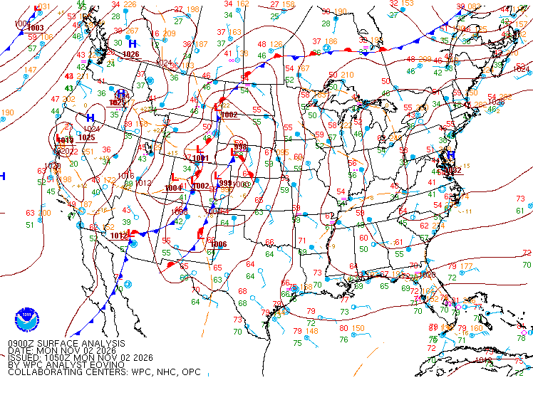
A strong ridge of high pressure in the upper atmosphere will “promote well above average temperatures through the next couple days from the Midwest to the Northeast,” the weather service said in its daily national briefing. It said Monday’s highs were forecast to run 15 to 30 degrees above average across the Midwest and parts of the Mid-Atlantic, and that the warmth would expand into New England on Wednesday.
The mild stretch is expected to peak Tuesday in the Great Lakes and Wednesday in the Northeast before a sprawling storm now soaking the Southwest sweeps east and brings rain to the East Coast late in the week.
Records Already Set in the Upper Midwest
The warm air had already left a mark on the record books by Sunday. The weather service office in Grand Forks, North Dakota, said the low temperature at Fargo’s Hector International Airport on Nov. 1 was 54 degrees, the warmest low on record for the date. That broke the previous record of 50 degrees set in 1969.
At Grand Forks International Airport, Sunday’s low of 49 degrees broke the record of 48 set in 2000, the weather service said. Airport records there go back to 1941. In northern Minnesota, the high at Baudette International Airport reached 66 degrees Sunday, tying records set in 2022 and 1981 in a temperature history that dates to 1908.
The Bismarck, North Dakota, office reported record warm lows Sunday at Bismarck, Dickinson and Jamestown.
In Minneapolis-St. Paul, the high reached 71 degrees Sunday, 21 degrees above normal for the date, according to the weather service’s daily climate report.
Farther east, Sunday’s highs were 70 degrees in Cleveland, 13 degrees above normal; 67 in Detroit, 12 above normal; and 68 in Indianapolis, 10 above normal, according to weather service climate reports.
Great Lakes Could Flirt With Records Tuesday
Forecasters in the Great Lakes region said Tuesday is likely to be the warmest day of the week as strong southerly winds pull warm air north ahead of the storm.
The weather service office in Detroit said “near record high temperatures” were possible Tuesday, with highs “solidly in the mid 70s” and overnight lows that may stay in the 60s. The office listed the Nov. 3 record highs as 76 degrees in Detroit, 79 in Flint and 74 in Saginaw, all set in 2015. Its forecast for downtown Detroit on Monday morning called for a high of 75 degrees Tuesday.
In Ohio, the Cleveland office said temperatures would “surge into the 70s” Tuesday as a warm front lifts north. “Some areas will flirt with record setting warmth on Tuesday,” forecasters wrote. Cleveland’s record high for Nov. 3 is 79 degrees, set in 1961, and the weather service forecast called for a high of 77.
In Indiana, the weather service forecast a high of 77 degrees Tuesday in Indianapolis.
In Chicago, forecasters expect highs in the low to middle 70s Tuesday, with south winds gusting to around 35 mph. Even after a cold front passes Wednesday morning, highs in the low to middle 60s will remain “above average for early November,” forecasters said.

Northeast Warms Through Midweek
The Northeast began the week on a much cooler note. The weather service office in Mount Holly, New Jersey, had a frost advisory in effect for parts of southeastern Pennsylvania and southern New Jersey until 8 a.m. EST Monday. Sunday’s highs were near normal in Philadelphia, New York’s Central Park and Boston.
That is expected to change quickly. The Mount Holly office said highs in the Philadelphia area would reach the mid-60s Monday, the upper 60s to low 70s Tuesday and the low to mid-70s Wednesday, with no further frost or freeze potential.
The New York office said highs would climb from the low to mid-60s Monday to the upper 60s to low 70s Wednesday and Thursday, about 10 degrees above normal. Overnight lows in the upper 50s to low 60s by Friday morning would be “close to normal high temps for parts of the area this time of year,” forecasters wrote.
In southern New England, the Boston office called it “dry and anomalous warmth” that will last into midweek. Highs are expected mainly in the upper 60s to low 70s, while interior areas could reach the mid-70s, “likely putting several daily high records in jeopardy,” the office said.
The weather service forecast for Boston called for a high of 73 degrees Wednesday. NBC10 Boston meteorologist Pete Bouchard said the city’s record for the date is 78. He wrote that if Boston strings together five straight days of 70 degrees or higher, it would break the city’s November record of four consecutive 70-degree days.
Dry Ground and Elevated Fire Danger
The warmth arrives during an extended dry spell across much of the East. The New York office described “the driest stretch of the year so far” for its area, which includes New York City, Long Island and parts of New Jersey and Connecticut.
The Connecticut Department of Energy and Environmental Protection rated brush fire risk as high in all eight of the state’s counties Sunday after “two weeks without measurable rain,” the New Haven Register reported. The agency urged residents to use extreme caution with open flames.
Bouchard wrote that breezes Wednesday and Thursday, combined with falling leaves and the dry spell, would likely raise fire danger in the Boston area.
The U.S. Drought Monitor released Oct. 29 said very little rain fell across the Northeast the previous week. It expanded abnormally dry conditions in parts of northeastern Pennsylvania, central upstate New York and northwestern New Jersey and expanded severe drought in central Maine. Severe to extreme drought in the region is confined to Maine, the monitor said.
Storm’s Rain to End the Warm Spell
The warmth will fade from west to east as the cross-country storm, which FOX Weather said would affect more than 35 states, moves out of the Plains. The storm’s cold front is expected to cross the Chicago area Wednesday morning and lower Michigan on Wednesday evening, with cooler, more seasonable air arriving by Friday and the weekend.
FOX Weather said rain should reach the Ohio Valley on Wednesday and the I-95 corridor around Thursday or Friday. It said widespread totals of more than an inch were possible across the Northeast, with localized amounts approaching 2 inches from central Pennsylvania and Maryland through the New York City area and southern New England.
The Mount Holly office said the rain looked most likely to be “just a beneficial wetting rain to the region.” The New York office put the chance of rain at 70% to 80% on Friday, its peak.
The Boston office said rain chances will increase from late Thursday through Saturday, with ensemble guidance showing a 30% to 60% chance of a half-inch or more. One more mild day is possible Saturday before seasonable temperatures return Sunday, the office said.
