Severe weather blossoming over Texas today will spread east tonight into tomorrow, setting the stage for a likely violent weather outbreak for portions of the southeastern U.S. Beyond tomorrow, this severe weather set-up will shift to the East Coast on Monday, bringing another day of potential severe weather to life there.
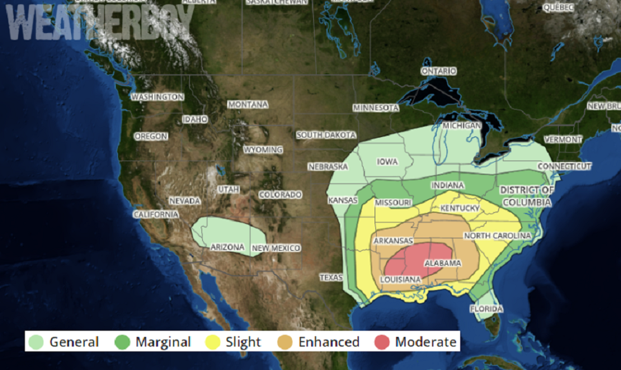
An outbreak of potentially violent thunderstorms appears likely Sunday into Sunday night, with the greatest threat expected from Louisiana through much of the Southeast and Tennessee Valley. Strong tornadoes, potentially widespread damaging winds, and large hail are all possible.
The ejecting shortwave trough initially over the southern High Plains on Sunday morning is forecast to move quickly eastward to the lower Mississippi Valley by early evening, and then accelerate northeastward toward the Ohio Valley late Sunday night into Monday morning, as it becomes absorbed within an amplifying longwave trough that will encompass nearly all the continental United States by mid-morning on Monday. In conjunction with the ejecting trough, a broad surface low centered over the central and southern Plains on Sunday morning will move eastward to the mid-Mississippi Valley by Sunday night and then move northeastward and rapidly intensify into an intense cyclone over the lower Great Lakes by Monday morning. A warm front will surge northward ahead of the low across the lower Mississippi Valley and Southeast, while a strong cold front will move southward through much of the Plains in the wake of the departing cyclone. These shifting weather features will be to blame for what could be quite a violent outbreak of severe weather.
According to the National Weather Service’s Storm Prediction Center, the magnitude and coverage of the severe threat in this region will be determined in part by how fast organized convection approaches from the west. If convection accelerates and arrives faster that current guidance would indicate, then there is less time for low-level moistening and destabilization, and the magnitude and northward-extent of the threat may be limited. If convection does not arrive until very late in the day, then a more substantial severe threat could evolve.
In these severe storms, high-scale, intense tornadoes are possible; in addition to having tremendous strength, they may be large and wide and track along the ground at substantial distances.
Beyond the threat of violent tornadoes, severe thunderstorms will also contain destructive wind gusts and large hail. All thunderstorms, severe or otherwise, can also include dangerous frequent lightning and heavy downpours. Some heavy rain bursts may create isolated flash flood conditions.
With many sheltering in place due to the COVID-19 Pandemic, severe weather action plans may be different than they usually are. Places that are safe shelters for the pandemic may not be safe for severe thunderstorms; people should judge how stable their structure is before severe weather arrives and take action to stay safe from both the pandemic threat and the tornado threat. Due to the pandemic, it may also take time for first responders and utility crews to report to and recover at disaster scenes.
