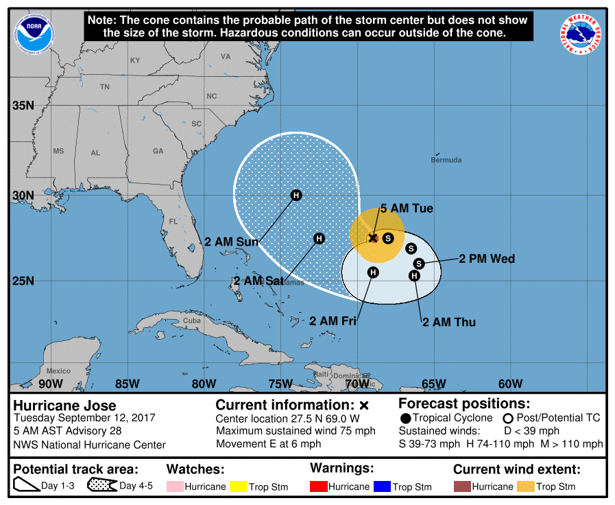
Now that the system once known as Major Hurricane Irma has degraded into a post tropical cyclone, attention is being directed to the Bermuda Triangle where Hurricane Jose bears watching. Storms in the current location of Jose could be a threat to the US east coast, especially the Mid Atlantic or New England coasts; sometimes the Canadian Maritimes could see direct impacts too. In the short term, Jose is expected to weaken to a tropical storm, but is expected to re-intensify back to hurricane status as it inches its way closer to the east coast.
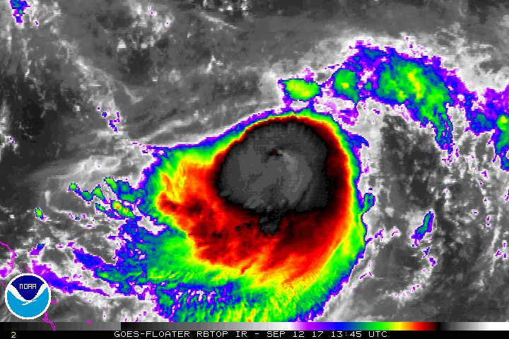
For a hurricane, Jose exhibits poor structure. This morning, Jose continues to be affected by northerly vertical shear and recent microwave imagery shows that the low-level center is to the northeast or north of a large burst of convection that shows little evidence of banding. While satellite intensity estimates have changed little since the last advisory, the sheared appearance suggests the cyclone has continued to weaken.
In the short term, Jose is forecast to move east, according to the National Hurricane Center (NHC.) As a mid-level ridge first builds around and then moves northeast of the cyclone, the track guidance forecasts Jose to make an anticyclonic half-loop during the next 72 hours. After that time, the confidence in the forecast decreases as the guidance diverges significantly. On the right side, the European ECMWF and Canadian forecast models forecast a turn toward the north and northeast, while on the left side the UKMET forecasts a westward motion towards the Bahamas. The American GFS and HWRF, along with other consensus models, are between these extremes ; they forecast a turn toward the northwest and eventually north-northwest. The new NHC forecast track is in best agreement with these models and shifts slightly to the right of the previous advisory at the end of the five day forecast.
The environment Hurricane Jose finds itself in will be evolving. A strong upper-level anticyclone near 28N 74W is the source of the current shear; this feature is supposed to weaken and pass north of the cyclone without allowing much decrease in the shear through 48 h. The large-scale models then suggest the possibility of lighter shear in about 2-3 days, followed by increasing shear as Jose encounters an upper-level trough moving eastward from the southeastern United States. Overall, the intensity guidance shows small fluctuations in strength during the forecast period, and there is little agreement in the guidance on the timing of the various ups and downs. The official NHC intensity forecast will follow the shear trends in calling for some additional weakening during the next 12-24 hours followed by modest re-intensification during the lighter shear, and then no change during the subsequent increase in shear.
It isn’t crystal clear yet whether or not Jose will make a direct impact to the east coast. However, indirect impacts are all but certain. Rough surf, high waves, and rip currents are likely along the entire east coast, not just from Hurricane Irma’s remnants, but from Hurricane Jose’s swells too. Whether or not there are more direct impacts from Jose, residents along the entire US east coast should make sure they have a Hurricane Action Plan. If Jose does threaten the east coast, it would likely be no earlier than next week.
Experts believe this Atlantic Hurricane Season, which runs through to the end of November, will be a busy one. Dr. Phil Klotzbach and the experts at Colorado State University updated their seasonal outlook again on July 5, showing a much more active than normal season expected. The National Oceanic and Atmospheric Administration (NOAA) also released their own forecast which shows this hurricane season to be likely more active than others.
