• Skip to primary navigation
  • Skip to main content
  • Skip to primary sidebar

Weatherboy

Weatherboy Weather News, Maps, RADAR, Satellite, and Forecasts.

  • Local
  • Earth Science News
  • RADAR
  • Current Warnings
  • Satellite
  • Current Maps
  • Forecast Maps
  • Video

White Christmas 2024 Forecast

by Weatherboy Team Meteorologist - December 7, 2024

 Source: National Oceanic and Atmospheric Administration (NOAA), Oceanic and Atmospheric Research (OAR), Climate Program Office (CPO), Climate.gov; NOAA National Centers for Environmental Information (NCEI)
Normal probability of a White Christmas. Source: National Oceanic and Atmospheric Administration (NOAA), Oceanic and Atmospheric Research (OAR), Climate Program Office (CPO), Climate.gov; NOAA National Centers for Environmental Information (NCEI)

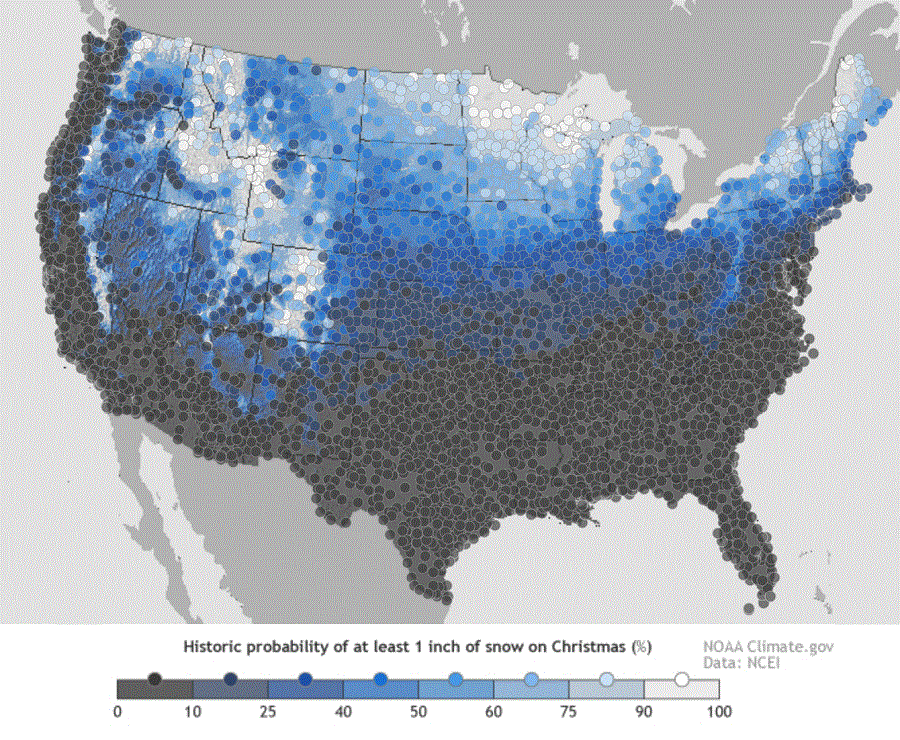
While some may be dreaming for a white Christmas, many are wondering if their dreams will turn into forecast reality. The map here shows the historic probability of there being at least 1 inch of snow on the ground in the Lower 48 states on December 25 based on the latest (1981-2010) US Climate Normals from NOAA’s National Centers for Environmental Information (NCEI).

The 1981–2010 Climate Normals are the latest three-decade averages of several climatological measurements. This collection contains daily and monthly normals of temperature, precipitation, snowfall, heating and cooling degree days, frost/freeze dates, and growing-degree days calculated from observations at approximately 9,800 stations operated by NOAA’s National Weather Service (NWS).

While the map shows the historical probability that a snow depth of at least one inch will be observed on December 25, the actual conditions in any year likely vary from the norm. Different weather patterns and storm systems each December set the stage for whether or not there will be snow on the ground for Christmas Day.

Latest snow cover map shows more of Canada and the northern U.S. is covered by snow now than it was this time last  year.  Image: NOAA National Operational Hydrologic Remote Sensing Center
Latest snow cover map shows more of Canada and the northern U.S. is covered by snow now than it was this time last year. Image: NOAA National Operational Hydrologic Remote Sensing Center

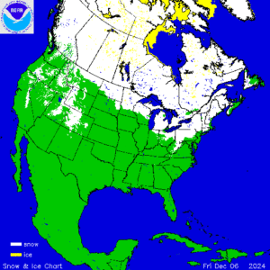
According to NOAA’s most recent analysis, many parts of the country are covered in snow. This includes  northern portions of New England, northern Michigan, parts of Iowa and Illinois, most of Idaho and Wyoming, portions of Utah, Colorado, California, Oregon, Washington, and Montana.

Compared to last year this time, there is actually more snow cover over the northern U.S. and Canada now. Whether or not that helps boost odds of a more widespread White Christmas forecast in the U.S. remains to be see.

Somewhat reliable computer guidance forecast extends 15 days; for now, that guidance suggests no significant snow changes to the I-95 corridor in the eastern U.S.. However it does suggest more accumulating snow will fall between now and December 23 across much of the northern Plains while the Northern Rockies should add to their snowpack.

To see if we’re calling for snow for your area, visit our local weather forecast page for your specific town here.

Primary Sidebar

Sponsored Ad

Search

Latest News

  • Heat Blast Expected from Texas to Florida and from Minnesota to Arkansas
  • Mid Atlantic to Become Extra Moist
  • Southeast Soaker Likely Next 72 Hours
  • Igloo Cooler Recalled Due to Amputation / Crushing Threat
  • Longtime TV Meteorologist Fired
  • Spacecraft Launched by Soviet Union in 1972 Crashed Back on Earth Today
  • Strong Tennessee Earthquake Reported by 35,000+ People
  • Updated Crash Forecast Puts Eastern U.S. on Alert from Soviet Union Spacecraft
About | Careers | Contact | Contests
Terms | Privacy | Ad Choices
Weatherboy is a (R) Registered Trademark of isarithm LLC, All Rights Reserved.
All content herein is Copyright by Isarithm LLC 1997-2022