
The National Weather Service has expanded Winter Storm Warnings south and east as new data supports forecast tweaks that dump a foot of snow or more not far from the New York City metro area later today into early tomorrow. This is a significant storm; the last time New York City was under a Winter Storm Warning and saw more than 4″ of snow was in 2022 on January 7.
An weather event that the National Weather Service is calling an “impactful winter storm” will drop snow beginning later today and continue through Saturday night. The storm appears to be tracking more north with more moisture than initially forecast, resulting in some changes with the advisories that are up and the snowfall that is expected.
The National Weather Service in Mount Holly, New Jersey upgraded the Winter Weather Advisories for
Somerset, Middlesex, and Monmouth to Winter Storm Warnings. This was largely done due to the potential for mesobanding to developing just south of the New York City metro area which would heavily impact travel along the New Jersey Turnpike and I- 78. However, the National Weather Service cautions that “southern portions of these three counties will likely not see the higher snow totals as sleet mixing in will significantly reduce snowfall totals.”
Winter Storm Warnings are also now up across portions of western Massachussetts and Connecticut, where 6″ or more is expected to fall. The same is true for all of Long Island where heavy snow is likely to fall.
In portions of southeastern Upstate New York, it is possible for snowfall amounts to exceed 12″ with snowfall rates of 1-2″+/hour and thundersnow storms possible at the peak of the storm, especially over the highest terrain there.
In the New York City metro area, generally 6-12″ is expected and it is unlikely for snow totals to approach a foot or more in the city itself.
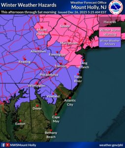
South of these areas, milder air will intrude into the cold air mass high over the surface. This will allow snowflakes to melt as they fall out of the sky and re-freeze, landing on the ground as sleet or ice pellets. With more sleet mixing in, snowfall accumulations will be a bit lighter than initially thought for places in southeastern Pennsylvania and southern New Jersey including the metro Philadelphia area.
The overarching theme still remains that the key threat will be widespread travel disruptions during the evening hours and heading into the overnight hours.
The setup for this storm involves an area of low pressure currently over the Great Lakes which will dive toward the Mid-Atlantic and move offshore by Saturday morning. Cold air will be firmly entrenched at the surface as a Canadian high pressure system locks in a cold air damming pattern across the Mid Atlantic. As the surface low digs through the Mid Atlantic it will bring a wintry mix of weather to portions of the Mid Atlantic and southern New England.
Ensemble guidance suggests that the heaviest snow band will set up near or just north of New York City between 7-11 pm, but could begin as soon as 5pm today.
Beyond snow and sleet, areas along and west of the Delaware River from Philadelphia south could also see some light icing, up to a 0.05″ or so. Freezing rain responsible for this ice accumulation will be very light, but it just takes a tiny amount of ice to create big travel problems. Due to the threat of this around Philadelphia, Winter Storm Watches that were up were upgraded to Winter Weather Advisories last night.
Going further south to far South Jersey, and northern Delmarva there is increased confidence in potentially some more icing compared to other locations. Low-level cold air will struggle to be removed as warm-air advection at the surface is not particularly strong. The result will be a period of freezing
rain and a Winter Weather Advisory for icing rather than snow has been issued for Salem and Cumberland Counties in New Jersey, New Castle County in Delaware, and Kent County in Maryland.
For the South Jersey coast and lower Delmarva, this will primarily be a rain event. While some flakes are possible at onset, a quick change to rain is expected.
Precipitation will taper off everywhere Saturday morning as temperatures struggle to warm into the 30s. For areas with a fresh snowpack anticipate sub freezing max temps while areas further south should be able to warm into mid to upper 30s.
There are no other winter storms expected in this region for at least the next 5 days.
