In what seems like an endless parade of winter storms, yet another one is expected to impact a large part of the eastern United States later this week, bringing another round of heavy snow and a mixed bag of precipitation.
Tomorrow, a cold surface high pressure system will build into the northeast from the Great Lakes and Ohio Valley regions. This high will shift across the Northeast Wednesday night as an area of confluence directs in eastward with time. This surface high will wedge its way southward, however, east of the Appalachians. As this occurs, a large upper-level trough moving its way across the Plains will shift eastward and develop surface low pressure across the Gulf coast states. This system will then track north and east near the leading edge of the upper-level trough and near a thermal gradient of cold air to the north and milder air to the south.
Unlike today’s storm which saw mild air surge far north, this very cold and very dry air mass arriving Monday will struggle to scour-out as low pressure moves into the northeast. As weak low pressure tracks up the Ohio Valley while a secondary low tracks across portions of the Mid Atlantic region Thursday into Friday, precipitation will eventually arrive. Clouds will increase Wednesday especially later in the afternoon and at night in the Mid Atlantic. An initial increase in warm air advection ahead of the developing surface low will be enhanced as it overruns the cold wedge of air in place in the region; this will result in some snow breaking out by daybreak Thursday in the southern Mid Atlantic. More precipitation will push north during the day, with moderate to heavy snowfall likely in places like Philadelphia and New York around the traditional rush hour Thursday.
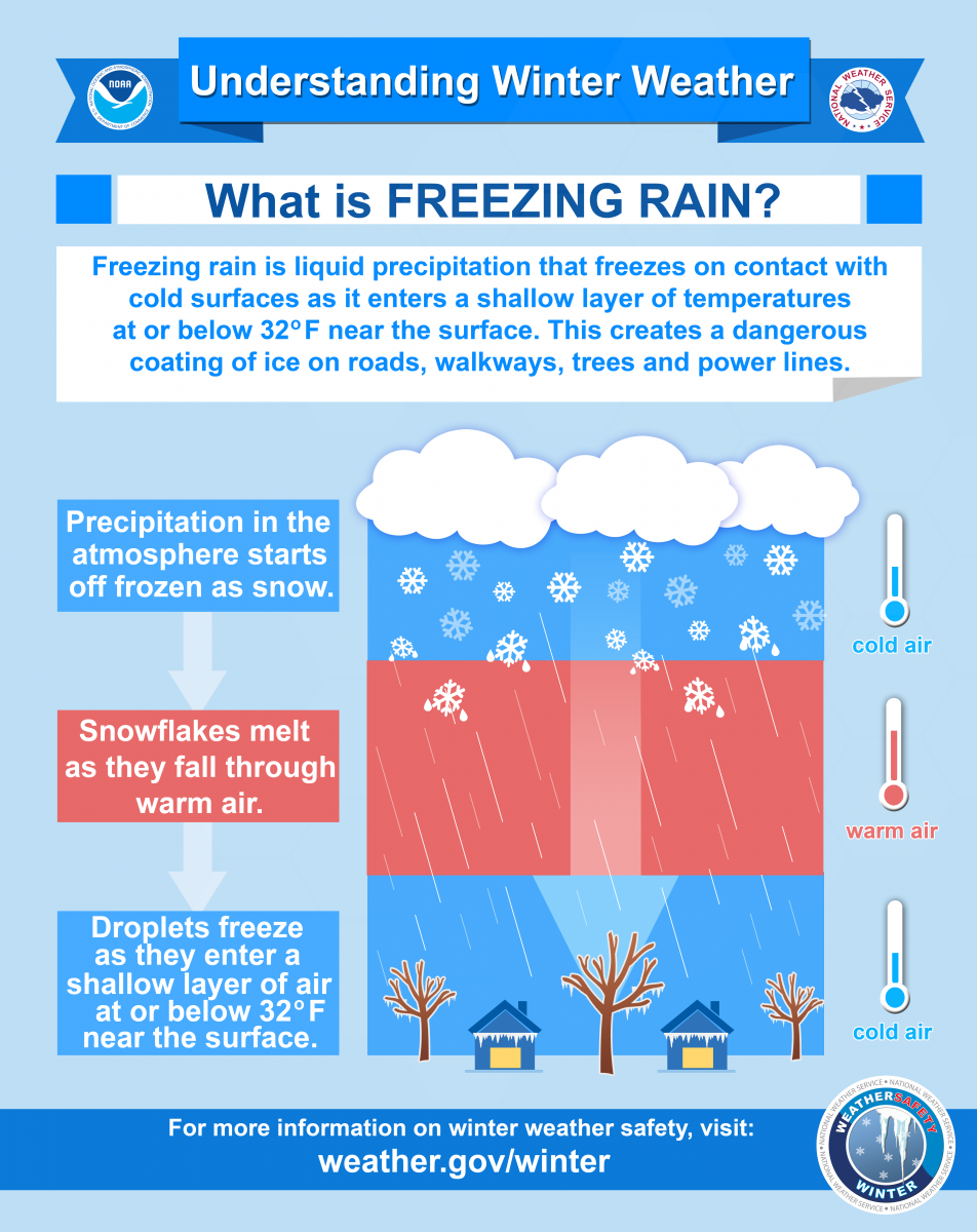
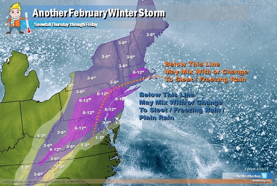
Milder air arriving from the south with battle with the cold air locked to the north. At this time, it appears the cold air will stay pretty firm near and just to the north / west of the I-95 corridor. However, some milder air will make its way in through mid levels of the atmosphere, which could lead to a mix with or change to sleet or freezing rain at times.
Further to the south, to the south and east of the I-95 corridor in Delaware, New Jersey, and New York, the mild air may win enough over the cold to mix precipitation with or change it over to plain rain.
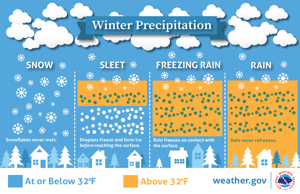
In either scenario, sleet or freezing rain would lower the maximum potential for snowfall. It is too soon to say with a high degree of confidence exactly where the all snow / mixed precipitation line will set-up; the same is true between the snow / rain line to the south.
Even with a mixed bag, as much as 6″ or more of snow could fall in Philadelphia, New York, and adjacent areas of New Jersey, eastern Pennsylvania, and Long Island. 6-12″ is also expected through central Pennsylvania and Maryland south into the higher elevations of West Virginia, Kentucky, Virginia, and Tennessee.
Across southern New England, near Boston, northern Rhode Island, and northeastern Connecticut, 6-9″ of heavier snow is possible there while the balance of the northeast will see 3-6″.
As with previous storms, Delaware and New Jersey will see the most dramatic differences with snowfall amounts from north to south, with 6-12″ expected in the northern parts of those states to only 1-3″ of snow due to mixing with non-snow precipitation types at the southeast shores.
While the heaviest snow will push through late Thursday, snow showers will linger over New England most of the first half of Friday. Snow will end from southwest to northeast across the Mid Atlantic to New England from early Friday morning to early Friday evening. On Saturday, fair high pressure will return with dry conditions.
With additional heavy snow on the way for Thursday and Friday, the National Weather Service will likely issue a fresh round of Winter Storm Watches and Warnings to portions of the Mid Atlantic and Northeast soon.
