
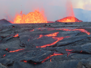
According to USGS, more than 250 earthquakes have rocked the Big Island of Hawaii in the last 24 hours, including more than 80 which were rated a magnitude 2.5 or greater event and 2 which were over a magnitude 4.0 event. With the sudden surge of seismic activity, scientists with USGS and the Hawaii Volcano Observatory have raised the Volcano Alert level there forcing other officials to close some areas near the Kilauea Volcano.
According to the Hawaii Volcano Observatory (HVO), increased earthquake activity and ground deformation at Kilauea’s summit began at approximately 12:00 pm local time, indicating the likely movement of magma in the subsurface. Rates of seismicity and deformation increased further after 5:00 pm. “At this time, it is not possible to say with certainty if this activity will lead to an eruption – the activity may remain below ground. However, an eruption in Kilauea’s summit region within Hawaii Volcanoes National Park is one potential outcome,” HVO warns.
Due to the increase in activity around the Kilauea Volcano, the USGS Hawaiian Volcano Observatory (HVO) is raising the Volcano Alert Level for ground-based hazards from ADVISORY to WATCH and the Aviation Color Code from YELLOW to ORANGE.
In the U.S., the USGS and volcano observatory units are responsible for issuing Aviation Codes and Volcanic Activity Alert Levels. Aviation Codes are green, yellow, orange, or red. When ground-based instrumentation is insufficient to establish that a volcano is at a typical background level of activity, it is simply “unassigned.” While green means typical activity associated with a non-eruptive state, yellow means a volcano is exhibiting signs of elevated unrest above known background levels. When a volcano exhibits heightened or escalating unrest with the increased potential of eruption, it jumps to orange. Finally, when an eruption is imminent with significant emission of volcanic ash expected in the atmosphere or an eruption is underway with significant emission of volcanic ash into the atmosphere, the code becomes red. Volcanic Activity Alert levels are normal, advisory, watch, or warning. As with aviation codes, if data is insufficient, it is simply labeled as “unassigned.” When the volcano is at typical background activity in a non-eruptive state, it is considered normal. If the volcano exhibits signs of elevated unrest above background level, an advisory is issued. If a volcano exhibits heightened or escalating unrest, a watch is issued while a warning is issued when a hazardous eruption is imminent.
With the Volcano Alert Level raised to WATCH and the Aviation Color Code raised to Orange, the National Park Service has announced some closures within Hawaii Volcanoes National Park. “Devastation Parking Lot and Keanakākoʻi area are closed due to seismic unrest and volcanic alert level raised to Orange or Watch,” the Park Service wrote in a brief statement shared on social media this evening. This area of the park along Crater Rim Drive, is a popular walking area to explore the drastic changes that occurred to the landscape near Kilauea’s caldera in the 2028 Lower East Rift Zone eruption of the volcano. Additional closure of areas within the park, including roads there, may be closed with little advance notice should an eruption occur.
Scientists at HVO studying this volcanic unrest say that it’s been driven by magma input to the main magma chamber, which lies beneath the area southeast of Kaluapele and south of Keanakākaoʻi crater.
Kilauea last erupted in September 2023.
