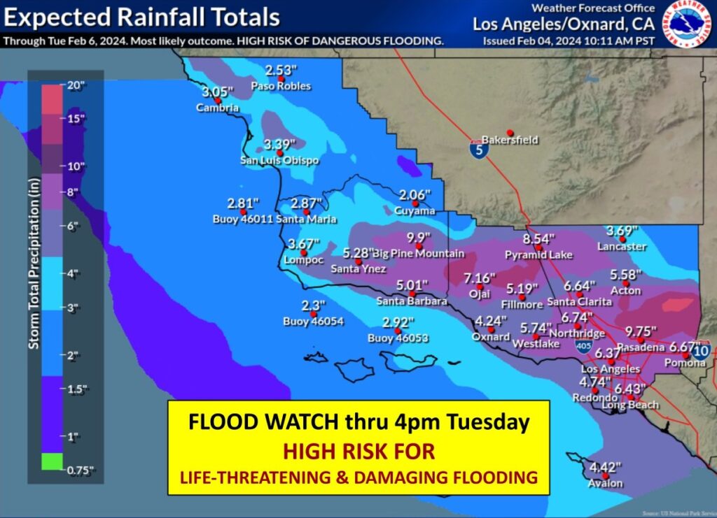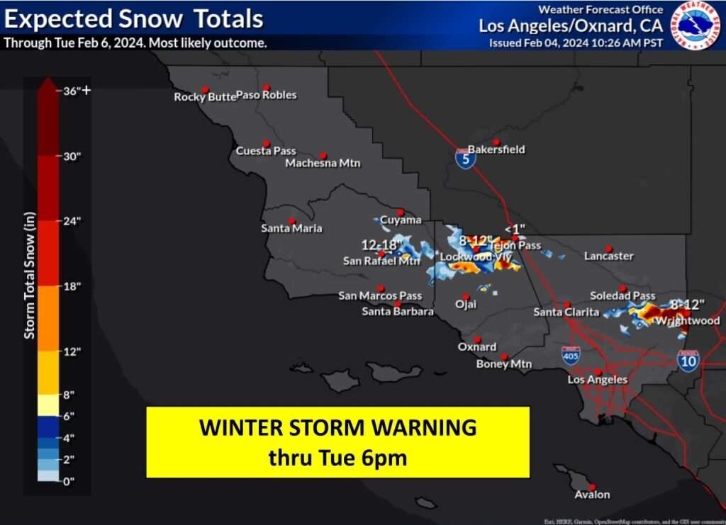
An atmospheric river event known as a Pineapple Express continues to plow through southern California today and is expected to dump incredible amounts of rain and snow over areas in the storm path through early Tuesday. As much as 8-14″ of rain is likely in southern California, with even the Los Angeles metro area seeing close to a half foot of rain. Very heavy snow, upwards of 5 feet, is expected to fall which will lead to mountain road closures, possible closures of I-5, and the threat of avalanches. The National Weather Service has issued numerous warnings for this region, urging people to get off roads during the peak precipitation times.
An atmospheric river refers to a narrow stream of concentrated moisture in the atmosphere. The most common atmospheric river event is nick-named “Pineapple Express”; in this type of situation, a robust stream of moisture near the Hawaiian islands flows north and east into western North America, dropping copious amounts of rain and snow as it interacts with the terrain there.
These long, narrow atmospheric rivers help transport moisture from the tropics, in water vapor form, to areas far from the tropics. The liquid equivalent of these moisture plumes could be comparable to the water flowing through the mouth of the Mississippi River, according to NOAA.
The worst of the storm is expected to strike from this evening through to Monday afternoon and people are urged to stay put on high/dry land until the storm passes.

In the latest Forecast Discussion issued by the Los Angeles / Oxnard, California office of the National Weather Service, meteorologists there wrote, “This is a DANGEROUS SYSTEM with major risks to life and property.” They elaborated by adding, ” Many roads and freeways will flood or shutdown. Canyon roads will experience significant rockslides. Low lying neighborhoods will see waters over curbs with a foot or two of water into vulnerable homes and businesses. Many parked cars will be damaged. Mudslides will occur over vulnerable areas. Recent burn scars will experience deep debris flows. Several creeks and the Ventura River will overflow their banks. Strong flows in all creeks and rivers will pose a risk for drowning for anyone in the channels, including the unhoused and anyone camping. The flooding risks are highest over Los Angeles County, including the urban areas. Many trees will fall, including in urban areas. Power outages could occur anywhere. Mountain communities above 6,000 feet may be shut off for a day or two with heavy snow covering access roads. Very large and steep waves will make the seas extremely dangerous over the open waters and along the coastline. Residents should heed any evacuation orders. Stay off the roads, especially the freeways, through at least Monday morning.”
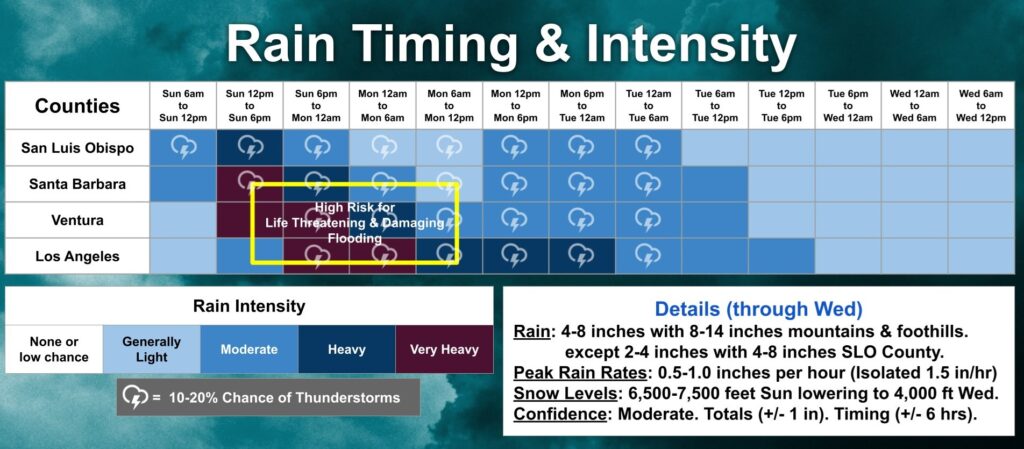
The deep moisture plume embedded in the warm front will continue to interact with very dynamic jet forcing to bring moderate to heavy steady rain to the region. According to the National Weather Service, the focus right now is over Santa Barbara and Ventura Counties where 1 hour rates between 0.75″ and 1.25″ per hour are occurring along with 3 hour totals of 1.5″-2.5″. The main rain band will slowly move to the south tonight and the latest projections continue to show it stalling over Los Angeles County from 6pm this evening through 6am Tuesday. It will not be heavy for that entire time, but there will be few if any breaks.
Generally 4-8″ will fall throughout the region with 8-14″ of rain in the mountains and foothills. There is also a 20% chance of embedded thunderstorms through Tuesday morning, which could lead to lethal lightning strikes in the heaviest rain showers.
Heavy snow will fall in the higher terrain. At 5,000-6,000′, 4-8″ of snow is expected. For 6,000-7,000′, 10-20 inches of snow is expected. At elevations of 7,000 feet or greater, 2-5 feet of snow is likely. The snow levels will also drop over the coming days. Snow levels of 6,500-7,500′ today will dip to 5,500-6,500′ tomorrow and 5’000-6,000′ by Tuesday. For the balance of the week, the snow levels will be down to 4,000-5,000 feet.

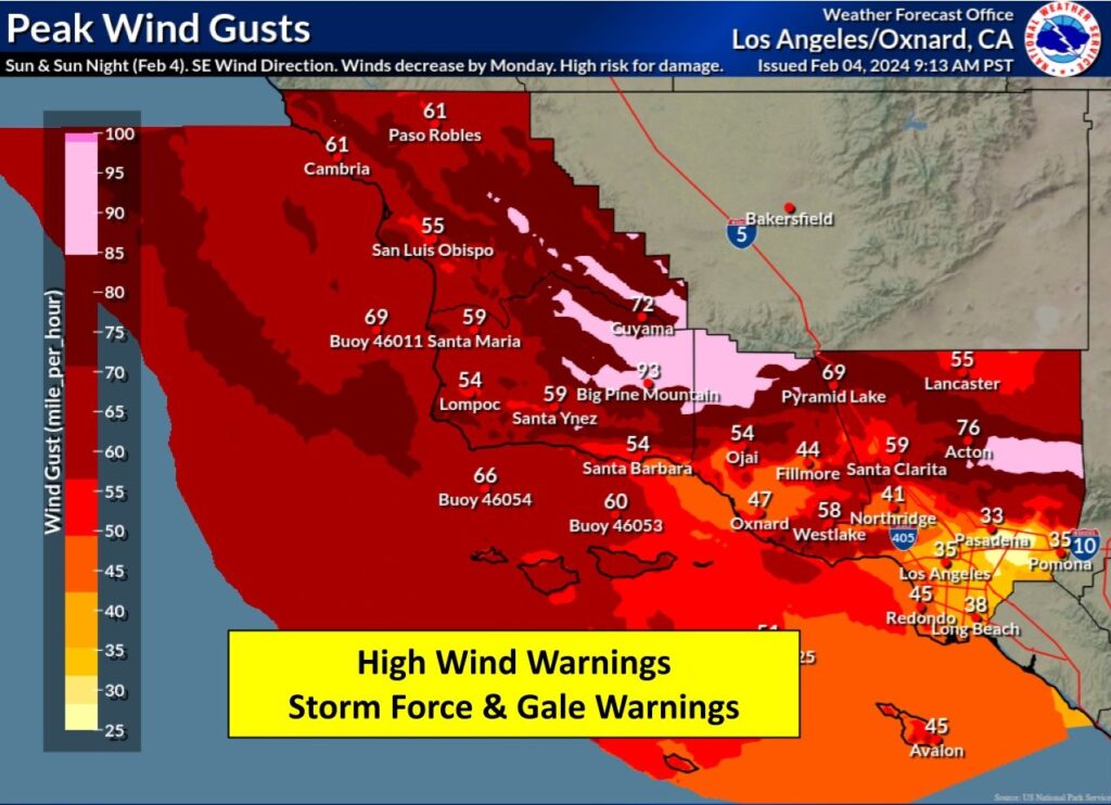
In addition to heavy precipitation, destructive wind gusts will also batter the region with tropical storm force and hurricane force winds possible along the coast, far inland, and in/around mountain peaks. 50-70 mph winds with gusts to 90 mph will blast the area, with the worst of the winds moving through Los Angeles from now through 1 am tonight. While much lighter winds are forecast for tomorrow, there will be significant impacts to the area due to many downed trees and wires, large areas with power outages, dangerous seas and harbors, and lingering airport delays at all Los Angeles – area airports.

Turn around, don’t drown! NEVER drive through floodwaters! #CAwx https://t.co/U59zLfbPGI
— the Weatherboy (@theWeatherboy) February 5, 2024