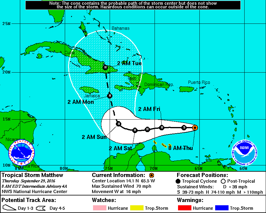
The National Hurricane Center expects Matthew to intensify further into a hurricane within the next 24 hours, with intensification to a 100mph hurricane possible within the next 72 hours. While forecast guidance differs on the future strength of this storm, it is important to point out that no significant model output is suggesting Matthew would grow beyond Category 3 strength (on a 1-5 scale) over the next 96 hours.
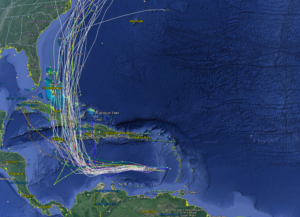
While confidence is increasing about Matthew’s forecast strength, confidence remains very low on its future track. As this map shows, model output along with thoughts shared by tropical meteorologists are very confident that Matthew will end its track to the west and begin a sharp north shift. What Matthew will do after this north shift remains in doubt, especially as the storm system enters the southern Bahamas. A very complicated weather pattern is evolving over North America next week and depending on the precise timing of Matthew’s arrival, the pattern could help pull Matthew up the coast, out to sea, or slam it inland. Until Matthew makes that north turn and interacts with Cuba, the meteorological community will likely know little about where the storm will go beyond the next 5 days.
While uncertainty remains in the extended forecast, there are many possible scenarios that may unfold –including some that may bring Matthew, as a hurricane, to the US east coast. As such, there are many things people should do now to prepare for possible impacts from this storm.
Residents in the Caribbean, especially Aruba, Curaçao, Jamaica, Haiti, and Cuba should make sure their Hurricane Action Plans are in order and that they’re properly supplied should storm conditions impact those areas later this week or weekend. Residents and visitors of the Bahamas, especially during the first week of October, should closely monitor forecasts. Check your Hurricane Insurance or Weather Insurance policies now to see if you’re protected from weather-related travel interruptions to your vacations and know what to do when a hurricane is forecast to strike. Residents and tourists alike should have Hurricane Action Plans prepared; it may become necessary to act on them early next week.
Further away in the United States, residents of -any- state that touches the Atlantic Ocean should have a Hurricane Action Plan. In general, you should completely understand where you live, how to identify it on a map, and understand the risks and threats a tropical cyclone brings to your area. If you live on the coastline or offshore islands, plan to leave. If you live near a river or in a flood plain, plan to leave. If you live on high ground, away from coastal beaches, consider staying. In any case, the ultimate decision to stay or leave will be yours. Study the following list and carefully consider the factors involved especially the items pertaining to storm surge. As part of your Hurricane Action plan, learn the storm surge history and elevation of your area; learn safe routes inland; learn location of official shelters. If you have a boat, determine where to move it in an emergency. Well before a storm arrives, trim back dead wood from trees, check for loose rain gutters and down spouts, and check shutters should you have them to protect from storms. If your shutters do not protect windows or you have no shutters for your home, be sure to stock boards to cover glass or at least know the size(s) of boards you’d need should a storm threaten your area.
Your Hurricane Action Plan should also inform you on what to do when a Hurricane Watch or Warning is issued for your area.
When a Hurricane Watch is issued for your area, check often for official bulletins from the National Hurricane Center and the National Weather Service. Fuel your car, check mobile home tie-downs, moor small craft or decide to move it to safe shelter, stock up on canned amd bottled provisions, check supplies of special medicines and drugs, check batteries for radio and flashlights, secure lawn furniture and other loose material outdoors, tape, board, or shutter windows to prevent shattering, and wedge sliding glass doors to prevent their lifting from their tracks.
When a Hurricane Warning is issued for your area, stay constantly tuned to National Hurricane Center and National Weather Service bulletins. If your home is sturdy and on high ground away from the coast, stay home and board up garage and porch doors; move valuables to upper floors; bring in pets; fill containers (such as a bathtub) with several days supply of drinking water; turn up refrigerator to maximum cold and don’t open unless necessary. In a Hurricane Warning, use phone only for emergencies; stay indoors on the down-wind side of a house away from windows. Be aware of the eye of the hurricane and where your home is in relation to it. If you’re in a mobile home, leave as quickly and as safely as you can. Leave other areas which may be affected by storm tide or stream flooding. Leave early in daylight if possible. If you’re leaving, make sure water and electricity are shut-off at main strations. Take small valuables and papers but travel light. Make a plan for pets: many storm shelters do not allow pets. If you’re evacuating, drive carefully to the nearest designated shelter using recommended evacuation routes. In evacuations, many roads will be closed while others are turned into 1-way highways away from storm danger areas.
As part of your Hurricane Action Planning now, you should walk yourself and your family through what you’d do if a Hurricane Watch or Warning were to be issued for your area. This practice will help inform you of what you need to do when a storm threat actually arrives. Acting smart and calm will save lives and property and being prepared now well in advance of any threat is the most smart thing you can do.
For the latest on Matthew and the rest of the tropics around the US in the Atlantic and the Pacific, visit our Hurricane & Tropical Weather page here: https://weatherboy.com/hurricanes-tropical-weather/
