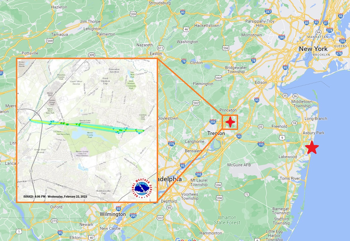
The National Weather Service has completed their storm survey of yesterday’s storm damage and confirmed that in addition to a waterspout that touched down off Sea Girt yesterday afternoon, an EF-2 ranked tornado plowed across portions of Mercer County near and through Mercer County Park.
In details shared by the Mount Holly, Burlington County, New Jersey office of the National Weather Service, meteorologists there identified the track and intensity of the tornado. Sporadic minor tree damage was observed west of Interstate 295 while a continuous path of tree damage was observed near Lawrence Station Road, particularly in a housing development along Fountayne Lane. The storm survey identified additional tree damage and damage to roofing occurred in a housing
development at Lawrence Square.
Based on damage observed in the area, the National Weather Service field crew estimated maximum wind speeds of 105 to 115 mph hit this area. In a straight line from this damage, there was roofing damage at a residence and a commercial building as well as additional tree damage along Quaker Bridge Road. Tree damage continued at a park across the street and through the 2nd and 11th holes at the adjacent golf course. Additional sporadic tree damage occurred in residential areas east of the golf course in West Windsor Township. The last tree damage was observed near the intersection of Old Trenton Road and Village Road.
With a RADAR-indicated tornado, the National Weather Service had issued a Tornado Warning for portions of Mercer and Middlesex County around and just before 4pm. Pea to marble sized hail was reported in portions of central New Jersey from the severe storms, including reports of wind damage. There was apparent wind damage to trees, buildings, and vehicles in the areas of Edinburg, Quaker Bridge, and West Windsor but it is still too early to know with certainty whether a tornado was responsible or if the damage was created by straight-line winds.
Measuring the area of damage and debris, the National Weather Service believes an EF-2 tornado was responsible for the damage along a 5.8 mile path which was 200 yards wide. It is believed the tornado touched down at 3:35 pm and lifted up at 3:41 pm.
Others have described other damage downstream from the path of this tornado, with damaged trees and buildings near Wayne Way, Dorchester Drive, Chestnut Drive, Glen Oak, Elm Drive, and Primrose Lane. However, a meteorologist at the Mount Holly National Weather Service office wrote, “Based on radar data and tornado path, it is likely that this damage was from straight line winds in the Rear Flank Downdraft (RFD) of the parent storm. It is typical for the RFD to “gust out” as the associated tornado dissipates, sometimes causing additional damage.”
Yesterday’s tornado was the 5th recorded tornado and the second recorded EF-2 tornado in New Jersey since records were kept in 1950. The last tornado to occur in February in New Jersey was on February 12, 1999, which was only rated a 1 which touched down in Cherry Hill. In 1973, there were three tornadoes, all of which hit in Hunterdon County. One of those was rated a 2 while one was 1.
Yesterday, the National Weather Service had confirmed via RADAR and video recordings that a waterspout touched down near Sea Girt on the Jersey Shore.
