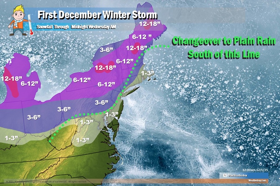
The first winter storm of the new month and season will be a significant one, with many expected to see over a foot of new snow between now and Wednesday morning in portions of the northeast. But with a lack of cold air in place and a storm path tracking close to the coast, the heavily populated I-95 corridor will see mainly rain.
The reason for this winter storm is a strengthening low pressure system moving northeast tonight and off the coast into Tuesday, which will bring widespread precipitation to the northeast, including the first accumulating snowfall to portions of the area. There will be a low developing over the southeastern United States with an area of high pressure retreating off to the northeast tonight too. This low will approach the New Jersey Shore Tuesday afternoon, and begin departing to the northeast by Tuesday night.
With cold air in place to start, even the I-95 corridor and places just south and east of it from Washington DC through Philadelphia and New York to Boston could see accumulating snow. However, as milder air moves in, this area will see a changeover to plain rain, washing away most of what accumulates, if anything.
However, north and west of here, the cold air will lock into place for the duration of the storm, allowing snow to accumulate fairly quickly. Upwards of 3-6″ of snow is expected over northeastern Pennsylvania and northern New Jersey. More than 6″ is expected there, with some areas of central Upstate New York, central New Hampshire, and interior Maine expected to get 12-18″ of snow.
The precipitation will end from west to east pretty quickly by Tuesday evening into Tuesday night as the low moves off to the northeast.
