
Snow is coming to the southeast on Sunday, with snowflakes likely to fly as far as the Florida west coast all the way into central South Carolina. However, those flying flakes are also expected to accumulate across portions of northwestern Florida, southeastern Alabama, and southwestern and central Georgia; mainly an inch or two is expected here while an isolated 3″ can’t be ruled out.
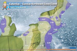
Low pressure along a stationary front over northeast Florida will travel northeastward along the coast through Sunday night. The low will produce rain over the Southeast that will expand northward into the Mid-Atlantic overnight Saturday. By Sunday morning, the precipitation along the western edge of the precipitation shield will change over to snow from parts of the Southeast to the Mid-Atlantic. The southern part of this storm system will drop the snow in the deep south while the northern part will bring accumulating snow to the north along the I-95 corridor between Philadelphia and New York City.
Due to the snow, the National Weather Service has issued Winter Weather Advisories and Winter Storm Warnings for the area. A Winter Weather Advisory is in effect for early tomorrow morning for southwest Georgia, southeast Alabama along the Chattahoochee River, and Jackson County, Florida. Winter Storm Warnings are up for Bibb, Twiggs, Wilkinson, Macon, Peach, Houston, Bleckley, Laurens, Sumter, Dooly, Crisp, Pulaski, Wilcox, and Dodge counties in Georgia including the cities of Toomsboro, Warner Robins, Macon, Vienna, Dublin, Eastman, and Americus.
The National Weather Service warns people in these areas: “If you must travel, keep an extra flashlight, food, and water in your vehicle in case of an emergency. The latest road conditions for the state you are calling from can be obtained by calling 5 1 1.” They said at the very least to expect slippery road conditions.
