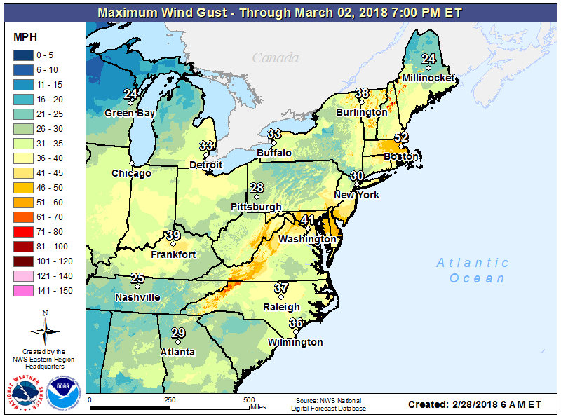
A severe coastal storm will be unfolding over the next several days across the northeastern United States, unleashing heavy rain and snow while whipping up the coast with battering waves, beach erosion, and moderate to major coastal flooding. Strong winds will also lash the region, with tropical storm force wind gusts likely far inland to the mountainous areas of the Mid Atlantic and Northeast.

The biggest threat to life and property from this storm system will be the coastal flood threat. This nor’easter-like storm will produce significant coastal flood problems across multiple tide cycles beginning late Thursday into early Saturday. Moderate flood conditions could impact Delaware, Maryland, New Jersey, Long Island, and southern New England, but some of the worst coastal flooding could occur around southeastern Massachusetts.
In Atlantic City, there could be at least four tide cycles impacted by at least moderate coastal flooding. As northeast winds push surf against the coast, the tides won’t be able to retreat as much as they usually due during low tide times. This cumulative addition of water through multiple cycles could put homes, businesses, and cars under water.
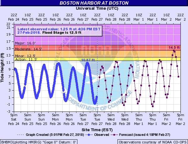
In Boston, the same is true there; moderate to major coastal flooding is expected there. In addition to storm surge flood threats, surf will be very rough. With high waves over 50 feet expected well off-shore, and significant waves of 6-12’+ impacting the immediate coastline, sand dunes and sea walls will be battered and eroded.
Residents living in areas prone to coastal flooding should put together plans to get out if necessary well before the storm impacts arrive. Salt water flooding from the ocean and back bays are especially destructive on cars, quickly rusting out everything from brakes to electrical components. As always, people should always turn around and not drown; never drive through flood waters.
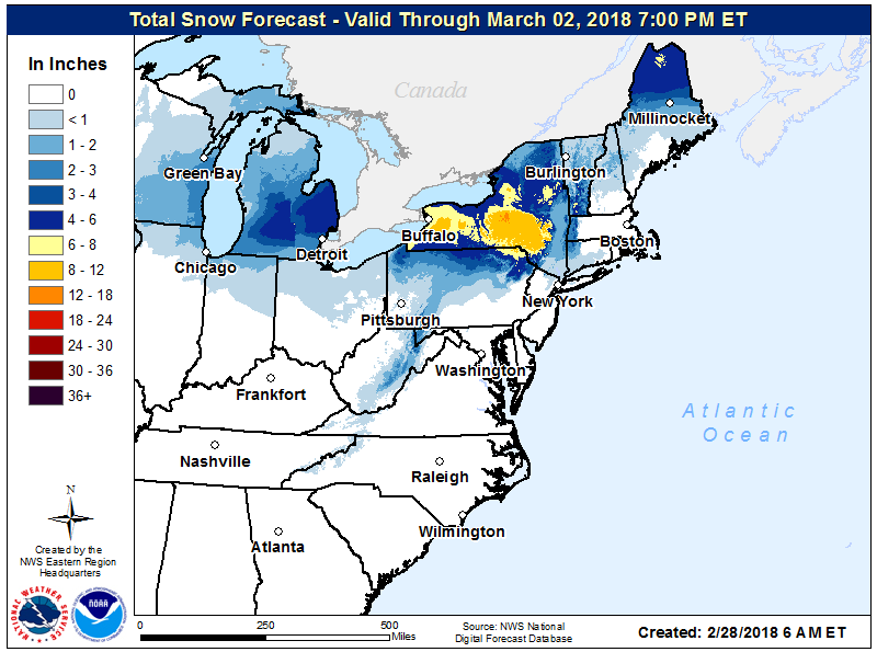
Heavy snow is also possible with this system, especially over northeastern New York. While the precise storm path and the storms ability to pull down or “generate” cold air in places will be key to who gets what snow and how much, it’s beginning more and more likely that southern upstate New York near the PA/NY border will see the most snow from this storm. There, more than 8″ of heavy, wet snow is possible, with some isolated areas exceeding 12″. Snow will fall heavy at times, making travel very difficult there.
Heavy rain will fall elsewhere, with 1-2″ expected around the I-95 corridor between Washington, DC and Boston, MA. Heavy rain could lead to some flash flood conditions, especially during heavier downpours. This flood threat will also exist at the coast, with storm water unable to exit the area with rising seas due to expected storm surge and coastal flooding.
Winds will be howling throughout the region, with damaging wind gusts possible across a wide area. Winds at tropical storm force will likely blow through Washington, DC, Philadelphia, PA, New York City, NY, and Boston, MA at times during this prolonged weather event. Combined with heavy wet snow inland, there could be tree limbs and wires tumbling as a result. Closer to the coast where rain is expected, soaked ground could make it easier for trees to topple in strong winds. There’s a threat of power outages throughout this region; people should prepare for the possibility of power outages. Winds will be at their worst at the highest elevations of the Appalachians and at the immediate coast line; wind damage to homes/businesses are possible in these areas. People throughout the northeast should secure any lose outdoor object, such as garbage cans, decorations, and toys.
