Another catastrophe is unfolding today in the land of aloha where another Kona Low type of storm is inundating the Hawaiian Islands with epic amounts of precipitation.
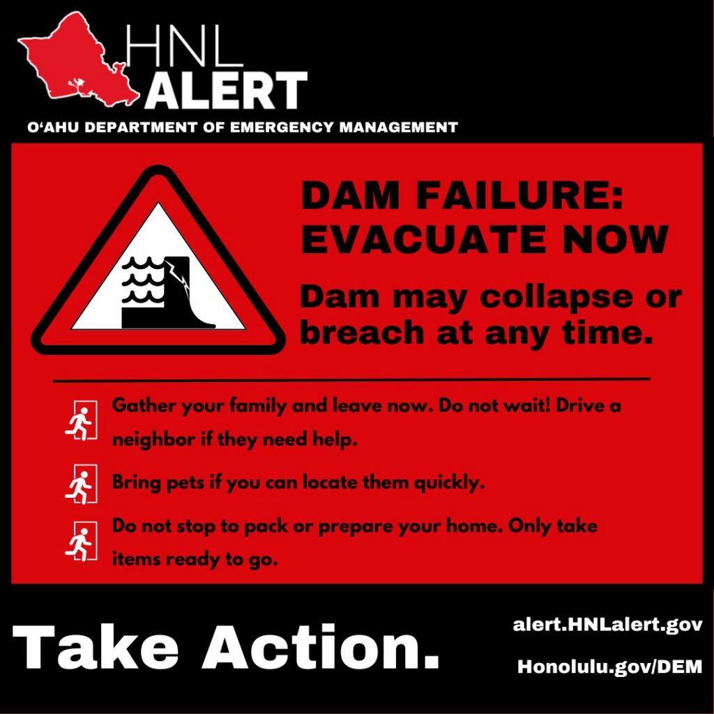
A Flash Flood Emergency has been declared for portions of Oahu where local law enforcement says a major dam is in imminent danger of collapse.
The latest Flash Flood Warning has been prompted by a dam failure on the Kaukonahua Stream below Wahiawa Dam on the island of Oahu in Honolulu County.
The National Weather Service warns about “Flooding of areas downstream from the Wahiawa Dam along the Kaukonahua Stream. The nearest downstream area from the dam is Waialua, Haleiwa, and Kaukonahua Stream. This includes the following streams and drainages: Kaukonahua Stream- Wahiawa, Waialua Town, Anahulu River- Haleiwa, Kaukonahua Stream- Schofield, Kaukonahua Stream- Waialua, Mohiakea Gulch, Poamoho Stream- Kaukonahua Highway, Kaukonahua Stream- North Fork Wahiawa, Helemano/Opaeula Stream- Haleiwa, Poamoho Stream- Dole Fields and Kiikii Stream- Waialua.” They add flooding is occurring along the Kaukonahua Stream.
Beyond this Flash Flood Warning tied to dam failure, there is a broader Flash Flood Emergency up for a larger part of the northern portion of Oahu. Emergency Management reported widespread life-threatening flash flooding effects continuing across northern Oahu, particularly in the Haleiwa and Waialua areas. The National Weather Service says that although rainfall rates have temporarily decreased, significant runoff continues to produce high water levels, including the Wahiawa Reservoir which continues to rise.
The National Weather Service warns, “This is a FLASH FLOOD EMERGENCY for Northern Oahu. This is a PARTICULARLY DANGEROUS SITUATION. SEEK HIGHER GROUND NOW!”
Unfortunately this is just the beginning of another round of heavy precipitation expected to impact the state while still cleaning up from the last major storm that ruined roads, destroyed crops, collapsed buildings, and left people still without power in parts of the state.
Today’s rain is just one part of a significant weather event that continues to unfold. A large band of heavy showers and thunderstorms has already dropped 5-10″ of rain in just six hours, causing catastrophic flooding in the northern part of the island. Roads in and out of Haleiwa are cut off, and water levels in low-lying areas remain dangerously high.
Today’s rain and additional rain coming is caused by two surface low pressure systems which will move slowly northeastward through the northern Hawaii region into the weekend, producing additional periods of moderate to heavy rain, thunderstorms, and elevated threats for flash flooding. A combination of low level forcing and passing upper level troughs will drive these smaller scale heavy rain band and thunderstorm formations.
Additional weather threats include strengthening south to southwest Kona winds on Saturday that will produce down sloping wind gusts in the 30 to 45 mph range along steep north and east slopes of island mountain ranges lasting through Saturday night. Fortunately, improving weather trends will develop from west to east on Monday as the atmosphere transitions to a wet trade wind weather pattern lasting through the end of next week.
But before then, a lot of rain and even snow is on the way.
Upper level troughing and a subtropical jet stream north of the islands continues to provide divergence aloft to help trigger heavier showers and a few thunderstorms over the next 24 hours. Threats for heavy showers and flooding will increase across the state into Saturday with the Kona Low drifting closer to Kauai.
The Kona Low gets its name from the change in wind direction that occurs when such a storm moves over the Hawaii Islands. Hawaii is dominated by the trade winds that typically blow in from the northeast. However, the counter-clockwise flow around a Kona low located west of Hawaii results in southwesterly winds over the islands, which is typically the leeward or “Kona” side. Kona Lows are most common between October and April. These type of storms draw abundant moisture up from the warm tropical waters that surround Hawaii; when this moist flow interacts with the steep topography of the island which helps to wring-out moisture, extremely heavy precipitation can fall. Because the wind flow around a Kona Low is atypical, flooding rains occur in places that may not ordinarily flood in tropical downpours that impact the islands from time to time.
A combination of low level forcing and passing upper level troughs will drive these smaller scale heavy rain band and thunderstorm formation. Some of these thunderstorms may become severe as wind shear and strong instability may lead to rotating strong thunderstorms producing damaging wind gusts and heavy rain threats. According to the National Weather Service in Honolulu, the latest weather model guidance remains fairly consistent with this Kona Low, increasing their confidence of an extended period of moderate to heavy rain falling across the state along with periods of thunderstorms lasting into Sunday.

There will also be strengthening south to southwest Kona winds on Saturday that will produce down sloping wind gusts in the 30 to 45 mph range along steep north and east slopes of island mountain ranges lasting through Saturday night. These strong wind gusts will likely uproot trees, as roots give way under saturated ground conditions, tree branches will break and fall, potentially producing another round of power outages for some local island communities.
Periods of icing and snowfall on the Big Island summits are possible above 12,000 feet elevation level along with strong gusty winds during the Saturday night through Sunday time period. No Winter Storm Watch is up for that area yet, but that could change tomorrow ahead of Sunday’s wintry weather arrival. The highest peaks of Hawaii Island were rocked by winds over 100 mph with heavy snow and blizzard conditions during the last Kona Low event just days ago.
