After an unprecedented airspace shut down during the early morning hours, authorities are still warning that the GPS scrambling of devices will continue across a broad area that extends across much of Texas, Louisiana, Oklahoma, and portions of New Mexico and Arkansas.
Without much explanation at the time, the FAA took drastic action late last night and suddenly ordered flights in and out of the El Paso International Airport to be halted for 10 days, causing shock and confusion. The FAA issued what are known as Notice to Air Missions, or NOTAM, alerting pilots that the air space over most of El Paso and over a large swath of New Mexico land west of Santa Teresa would be closed for 10 days for national security reasons.
The restrictions took effect at 11:30 pm and the notices warned pilots that “the United States government may use deadly force against the airborne aircraft, if it is determined that the aircraft poses an imminent security threat.”
The last time airspace was closed like this was in the wake of the attacks of September 11, 2001.
However, during the mid-morning hours on Wednesday, the FAA removed the alert and told the public, “The temporary closure of airspace over El Paso has been lifted. There is no threat to commercial aviation. All flights will resume as normal.”

U.S. Transportation Secretary Sean Duffy wrote on X, “The FAA and DOW acted swiftly to address a cartel drone incursion. The threat has been neutralized, and there is no danger to commercial travel in the region. The restrictions have been lifted and normal flights are resuming.” DOW is the Department of War.
Steven Willoughby, the Deputy Director of the counter-drone program at the Department of Homeland Security, told Congress last July that cartels are using drones nearly every day to transport drugs across the border and surveil Border Patrol agents. More than 27,000 drones were detected within 1,600 feet of the southern border in the last six months of 2024, he testified, mostly at night.
According to the Department of Homeland Security, Mexican cartels have long used drones to traffic drugs, control migrant crossings along the border and wage war with rival cartels and authorities. Mexico first issued an international alert about the use of such remote controlled aircraft more than 15 years ago.
Some media outlets have suggested that the Pentagon planned to use a high-energy, counter-drone laser as part of today’s operation, but the Pentagon has yet to confirm that.

El Paso International airport describes itself as the gateway to west Texas, southern New Mexico and northern Mexico. Southwest, United, American and Delta all operate flights there; according to FlightAware, 14 flights in and out of the airport were canceled due to today’s incident.
While the matter of shutting down airspace is over, another mysterious issue lingers. In what may or may not be related to today’s incident and the shut down of airspace. the U.S. Army announced weeks ago that it would be conducting overnight GPS jamming testing across a huge swath of Texas for most of February.
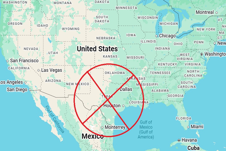
Tonight and tomorrow from 11 pm to 5 am, from 2:01 am to 5 am for February 13-14, and from 11pm to 5 am from February 15 to 22 from 11 pm to 5am, and from 2:01 am to 5am through to February 27, the U.S. Army may jam or scramble GPS signals including WAAS, GBAS, and ADS-B within a 600 mile diameter circle of airspace up to 25,000 feet.
This circle is centered on Fort Hood, which is roughly 60 miles north of Austin. The test area includes major cities and airports including Dallas, Houston, San Antonio, and Oklahoma City; the Army warns that there could be “unreliable to unavailable signals.”
These systems allow for auto-pilot to work on airplanes and help with navigation systems for commercial, military, and private aircraft. This issue happening in the air could also disrupt cars, trucks, phones, watches, computers, routers, and other systems that use GPS on the ground.
In an alert to pilots, the FAA said, “Pilots are encouraged to report anomalies in accordance with the Aeronautical Information Manual (AIM) paragraphs 1-1-13 and 5-3.”
Beyond the FAA alert, the U.S. Army and the DOW have yet to clarify that is happening in Texas with this latest alert or what is being tested or why.
