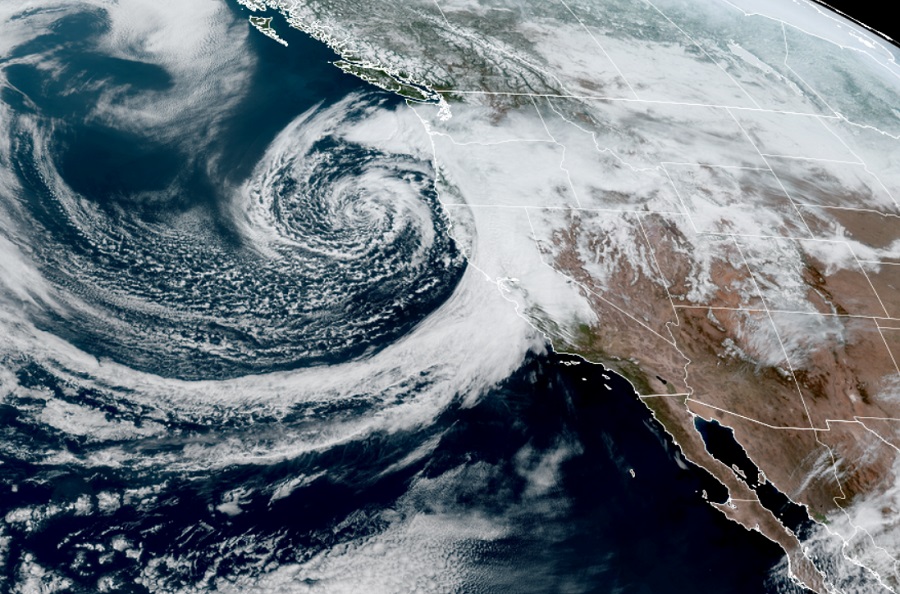
Another in a series of potent atmospheric river events will continue to unfold across the U.S. West today, as an area of low pressure slams into the California coast. More epic rain and snow is expected in areas that have already received epic amounts of record-breaking rain and snow; rainfall measured in feet and snowfall measured in yards is expected once again.
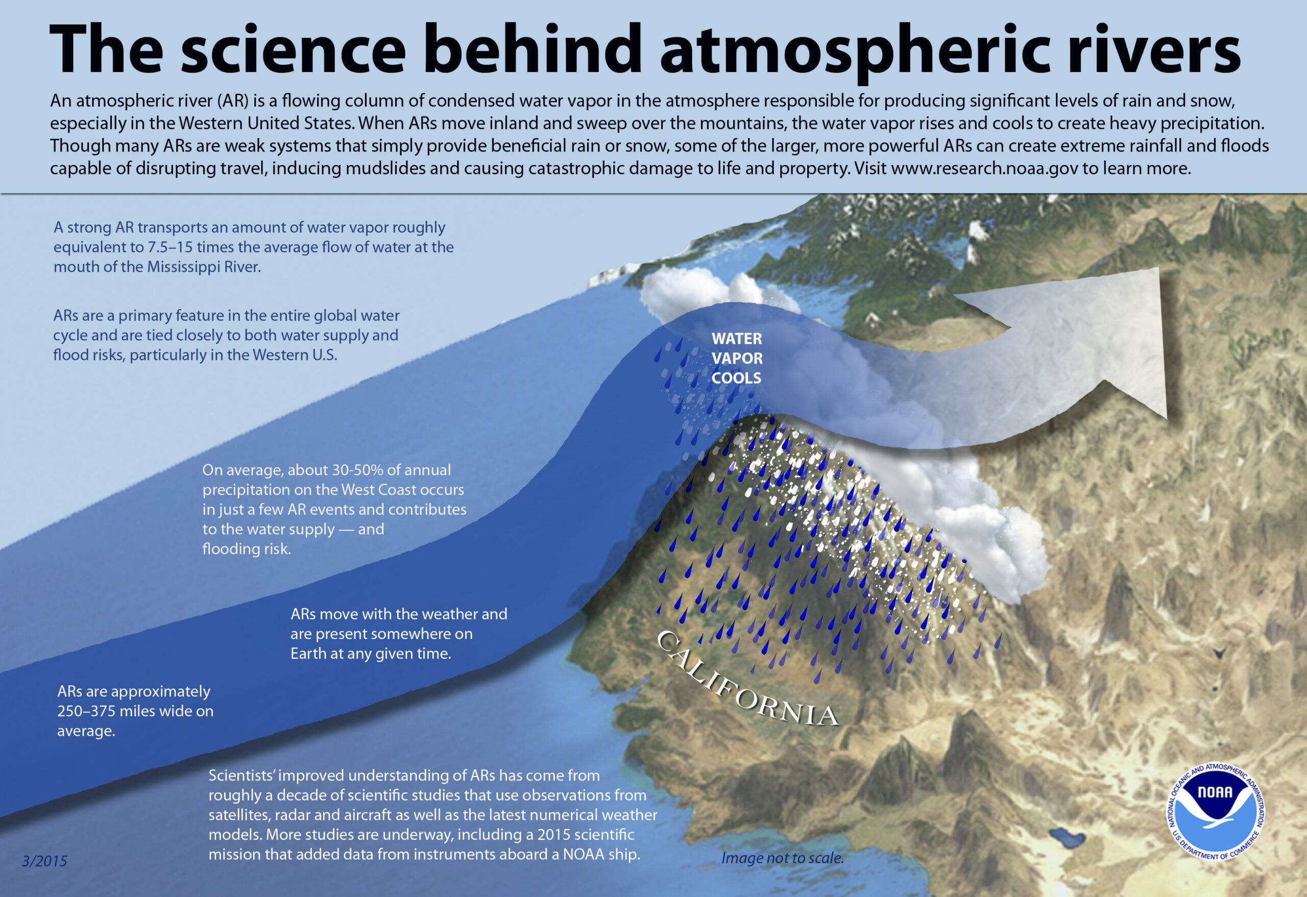
An atmospheric river refers to a narrow stream of concentrated moisture in the atmosphere. The most common atmospheric river event is nick-named “Pineapple Express”; in this type of situation, a robust stream of moisture near the Hawaiian islands flows north and east into western North America, dropping copious amounts of rain and snow as it interacts with the terrain there.
These long, narrow atmospheric rivers help transport moisture from the tropics, in water vapor form, to areas far from the tropics. The liquid equivalent of these moisture plumes could be comparable to the water flowing through the mouth of the Mississippi River, according to NOAA.
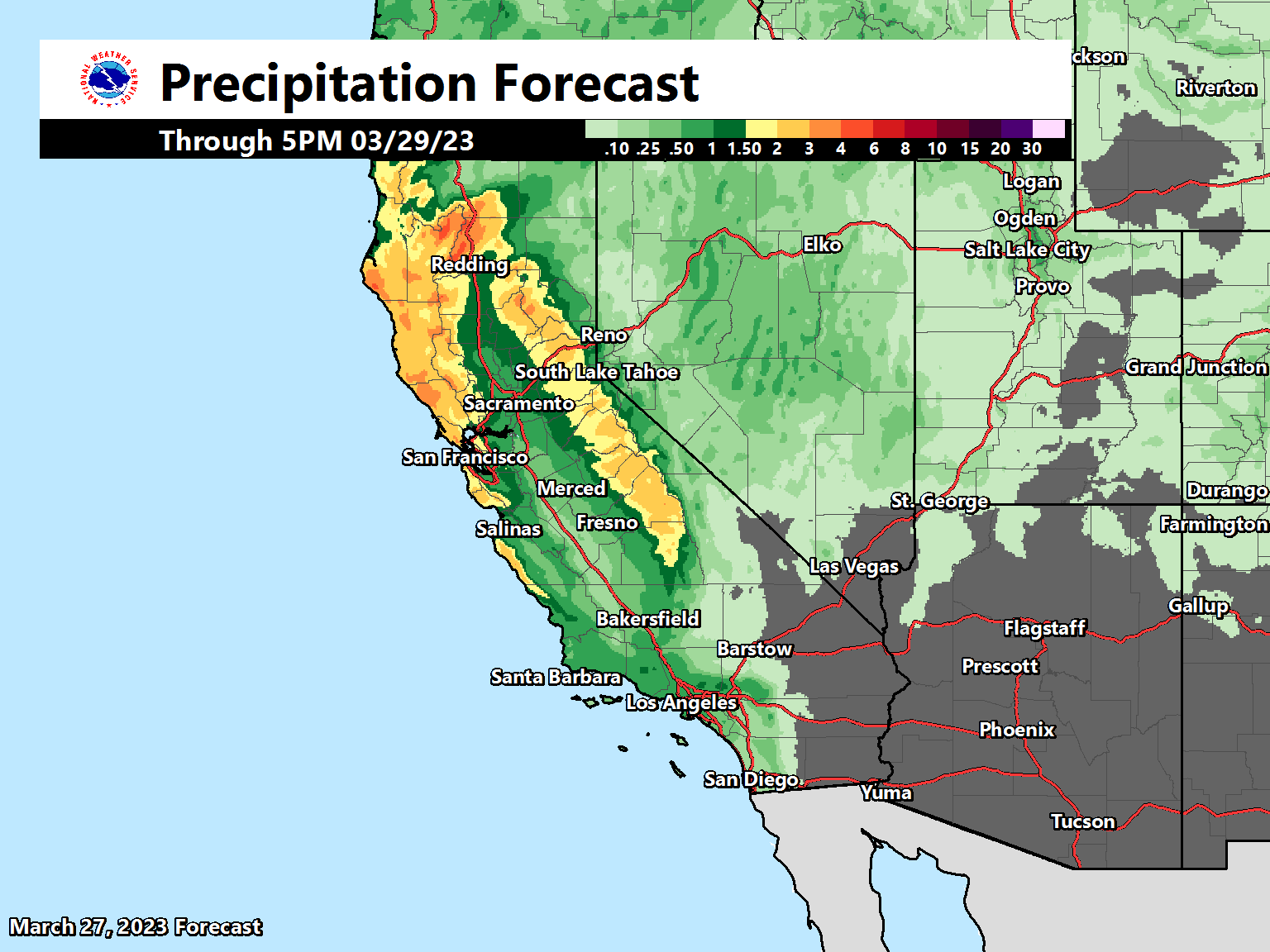
According to the National Weather Service, the powerful Pacific storm system continues to impact much of the Pacific Northwest and northern California, bringing in moderate to heavy rain and heavy snow to the higher elevations. Some areas of locally heavy rain may impact portions of the central California coast through Tuesday night. Terrain-enhanced rainfall will spread into the coastal ranges which will increase the risk for runoff into local rivers and the potential for rapid onset flooding. Antecedent soil conditions also remain very wet given the repeated rounds of heavy rainfall over the last few months, increasing odds of flood problems.

Additionally, very heavy snow is forecast for higher elevations of the northern coastal ranges and the Sierra, with storm-total snowfall likely be upwards to 1-3 feet or more by late Wednesday. Some isolated 4-5 foot amounts are possible too, adding onto epic snow cover that already exists across the highest mountain terrain. Additional moisture spreading inland over the Great Basin will bring moderate to locally heavy snow to the Blue Mountains of Oregon, the Saw Tooth Range of Idaho, and higher elevations of the central mountain ranges of Nevada. Little to no accumulating snow is expected for lower elevation valley locations.
Winds will also remain rather gusty Tuesday over portions of California, Nevada, southern Oregon, and northwestern Arizona.
High temperatures will continue to be below average for much of the West Tuesday and Wednesday, with highs in the 30s and 40s for the Northern Rockies/Great Basin and the 50s for most of California. Some high temperatures over the next few days in California may break or tie the coldest maximum temperature for that date. Meanwhile, highs over the Pacific Northwest will be closer to average for this time of year, with much of the region’s highs in the upper 50s. Warmer air flowing northward ahead of the approaching Pacific front will push highs into the 60s and 70s for the Southern Rockies and the 80s for portions of the Desert Southwest Wednesday. However, a cold front will push across the region on Thursday, cooling temperatures over Arizona and Utah significantly. Highs will be in the mid-60’s in southern Arizona, and only in the 30s and 40s to the north.
