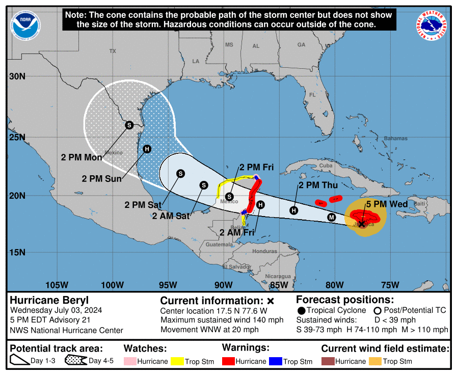
Major Hurricane Beryl continues to pound Jamaica at this hour, lashing the island with destructive winds and storm surge and flooding rains. The hurricane will plow into Mexican’s Yucatan Peninsula next but there isn’t as much confidence with where it will strike next. Due to the lack of confidence in the extended forecast, there is concern for both the Texas and Mexican Gulf Coast that Beryl may eventually strike there with time.
Right now, the center of Beryl is roughly 65 miles west-southwest of Kingston, Jamaica and about 265 miles east-southeast of Grand Cayman. With maximum sustained winds of 140 mph, the hurricane is moving to the west-northwest at 20 mph. Its minimum central pressure is at 959 mb or 28.32″.
Numerous watches and warnings are in effect. A Hurricane Warning is in effect for Jamaica, Grand Cayman, Little Cayman and Cayman Brac, and the coast of the Yucatan Peninsula of Mexico from Puerto Costa Maya to Cancun. A Hurricane Watch is in effect for the coast of the Yucatan Peninsula of Mexico south of Puerto Costa Maya to Chetumal, and the coast of the Yucatan Peninsula of Mexico north of Cancun to Cabo Catoche. A Tropical Storm Warning is in effect for the coast of the Yucatan Peninsula of Mexico south of Puerto Costa Maya to Chetumal and the coast of the Yucatan Peninsula of Mexico north of Cancun to Cabo Catoche. A Tropical Storm Watch is in effect for the coast of Belize from south of Chetumal to Belize City and for the soast of the Yucatan Peninsula of Mexico west of Cabo Catoche to Campeche.
A Hurricane Warning means that hurricane conditions are expected somewhere within the warning area. Preparations to protect life and property should be rushed to completion. A Tropical Storm Warning means that tropical storm conditions are expected somewhere within the warning area within 36 hours. A Hurricane Watch means that hurricane conditions are possible within the watch area, generally within 48 hours.
A Tropical Storm Watch means that tropical storm conditions are possible within the watch area, generally within 48 hours.
According to the National Hurricane Center (NHC), Beryl will continue marching off to the west and north with time. Right now, Beryl is moving toward the west-northwest near 20 mph and this general motion should continue through this evening, followed by a turn more toward the west tonight or Thursday. On the forecast track, the center is expected to pass near or over the Cayman Islands tonight or early Thursday and move over the Yucatan Peninsula of Mexico Thursday night or early Friday.

Maximum sustained winds are near 140 mph with higher gusts, making it a category 4 hurricane on the Saffir-Simpson Hurricane Wind Scale. According to the NHC, some weakening is forecast during the next day or two. However, Beryl is forecast to be at or near major hurricane intensity while it passes the Cayman Islands. Additional weakening is expected thereafter, though Beryl is forecast to remain a hurricane until it makes landfall on the Yucatan Peninsula.
The National Hurricane Center wants four key messages shared:
- Devastating hurricane-force winds, life-threatening storm surge, and damaging waves are expected to continue in Jamaica over the next several hours and spread into the Cayman Islands tonight. Mountainous locations in Jamaica are likely to experience destructive wind gusts.
- Life-threatening flash flooding and mudslides from heavy rainfall are expected over much of Jamaica and southern Haiti through today.
- Damaging winds, a dangerous storm surge, and heavy rainfall are expected over portions of the Yucatan Peninsula and Belize beginning Thursday night as Beryl approaches that area as a hurricane. Hurricane and Tropical Storm Warnings are now in effect for portions of that area.
- There remains uncertainty in the track and intensity forecast of Beryl over the western Gulf of Mexico this weekend. Interests in the western Gulf of Mexico, including southern Texas, should monitor the progress of Beryl.