The first significant severe weather event of the new meteorological spring is forecast to unfold over the next 36 to 72 hours. Meteorological spring, which began on March 1, is a season where conflicting air masses collide as winter transitions to spring, setting the stage for occasional outbursts of severe weather. According to the National Weather Service’s Storm Prediction Center, this next round of severe weather is about to strike.
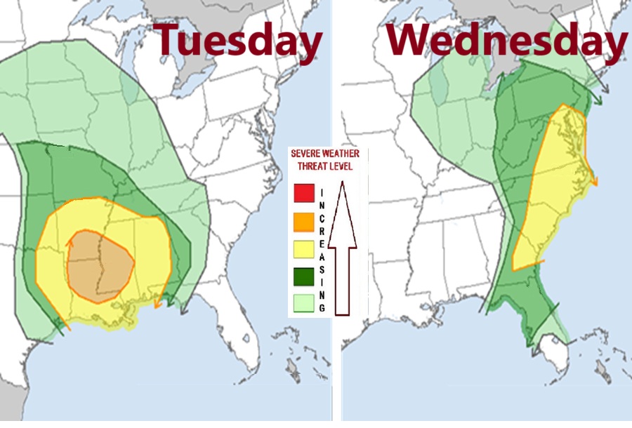
On Tuesday, the greatest threat of severe weather will be anchored over the northern half of Louisiana, much of Mississippi, and southern Arkansas. According to the Storm Prediction Center (SPC), one or two organized lines or clusters of thunderstorms, and perhaps a few supercells, will pose a risk for damaging wind gusts, a few tornadoes and hail, primarily across parts of the lower Mississippi Valley into the Southeast, Tuesday through Tuesday night.
This area of severe weather will march towards the east coast on Wednesday, with the greatest risk of severe weather stretching from southern New Jersey into eastern Georgia. Here, severe thunderstorms capable of producing damaging winds and a few tornadoes are possible across parts of the southern and middle Atlantic Seaboard on Wednesday.
According to the SPC, computer forecast models indicate that surface dew points may increase into the 60s in a corridor across the Carolinas through Virginia during the day. Although lower/mid-tropospheric lapse rates are forecast to be rather weak, weak near-surface destabilization might become sufficient to support a risk for tornadoes and/or damaging straight line wind gusts here.
In the wake of this initial band of convection, beneath a developing dry slot, northward moisture advection and insolation to the lee of the Blue Ridge may contribute to modest destabilization by late Wednesday afternoon. It appears that this will be aided by the leading edge of stronger mid-level cooling spreading to the east of the Appalachians, and accompanied by increasing thunderstorm development in the presence of strong deep-layer shear. The SPC warns, “the environment may still become conducive to supercells with potential to produce severe wind, hail and perhaps a tornado.”
