A witches brew may not be the only thing brewing for Halloween this year: chances are increasing that a large-scale coastal storm will form, bringing wind-whipped rain and possibly snow to the northeast at the end of the month. While it’s been wavering back and forth the last few days, global forecast guidance provided by the European ECMWF and the upgraded American GFS systems show the possibility of a significant coastal storm forming in the northeast at/around October 27.
With northeast impacts from a storm just 10 days away, accuracy of global forecast models will improve. However, because more than 5 days exist from now to the time the storm forms, many questions remain and the overall confidence in the extended forecast is low. While the European and American forecast guidance is aligned to the idea of a major coastal storm, there are big differences between them and those differences are just as likely to broaden as they are to narrow over the next few days.
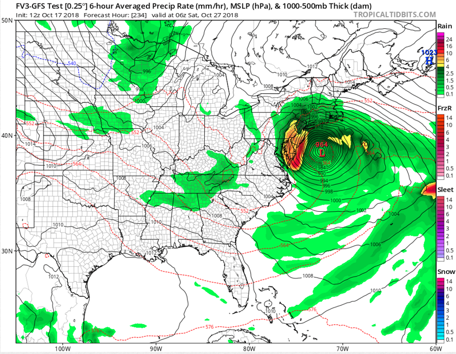
The American GFS model is the more aggressive of the two. It has a storm system forming over the Gulf Coast, bringing heavy rain and gusty winds to areas recently hit hard by Hurricane Michael. From there, it barrels the system up the coast, bringing very heavy precipitation and very strong winds to the Mid Atlantic Coast, with Maryland, Delaware, New Jersey, southeastern New York, and eastern Pennsylvania seeing the worst. While the storm impacts the Mid Atlantic in about 10 days, the GFS shows general steering currents weakening over time, keeping this low pressure area over the Canadian Maritimes for several days as it exits the U.S. northeast coast. If such a solution were to occur, it would keep unsettled weather in place over the northeast through Halloween and the first day or two of November. The American GFS system eventually wraps cold air into the backside of this system, possibly setting the stage for some upper elevation wet snow in the Appalachians. Overall, though, the American model solution is a milder one with rain the dominant precipitation type throughout the northeast.
Like the American GFS, the European ECMWF forecast model has a system forming over the Gulf Coast. And like the GFS, it brings unwanted rain and wind to areas hit hard by Hurricane Michael. But unlike the GFS, it has most of the system’s energy heading off-shore before intensifying near the Canadian Maritimes. This system would bring wind-whipped precipitation to the northeast, although the heaviest precipitation is more north than the GFS. And because of the system’s forecast location, more cold air has the opportunity to enter the system, which could produce more snow than rain for some locations in the northeast, including the northern Mid Atlantic. While non-accumulating flakes could fly in the northern Mid Atlantic, the European model does suggest heavy accumulating snow to portions of New England which could set the stage for a very early ski season –if it verifies.
Whether or not these forecast models verify remains a big “if.” Because there’s been a signal for a while that a substantial east coast storm would form in the eastern US around this period, it’s likely something will form. How big it becomes and how mild/cold/wet/dry it is will remain an unanswered question for several more days from now.
