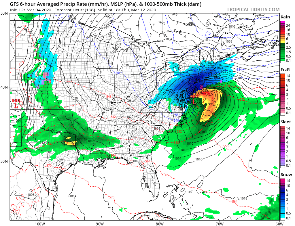
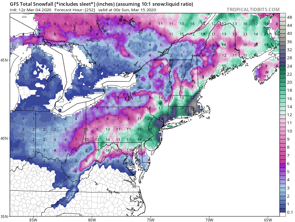
The latest American GFS forecast model suggests a blockbuster blizzard could dump heavy snow on an area that has seen little to none of it this winter, but is it even possible? Meteorologists are asking that question today while reviewing data from the bullish model that has been suggesting a wintry solution for portions of the Mid Atlantic and Northeast for later next week, for the last several days. While it is indeed possible, snow lovers shouldn’t hang their hat on the latest model run; the forecast solution it suggests today will likely change many times before the storm ingredients form next week.
Some of the largest snowstorms in the East have hit in March. The most famous of the bunch was the Blizzard of 1888 which struck March 11-14. The most potent of the bunch was likely the “Superstorm” of 1993, which had the highest NESIS value of any east coast winter storm since 1956. The March 1960 Blizzard was another major storm which struck March 2-5 that year; it had the third highest NESIS value for any storm. Other considerable storms included March 8, 1941 and March 5, 1981, each which dropped heavy snow on New York City.
Unseasonably mild and wet weather impacted the northeast ahead of the Blizzard of 1888. Heavy rain turned to heavy snow over the New York City area on March 12 and continued for a solid 36 hours. The National Weather Service estimates that storm dropped 50″ of snow over portions of Connecticut and Massachusetts while New Jersey and New York had up to 40″ of snow. In New York City, snow drifts of up to 52 feet high were measured in Gravesend, Brooklyn, paralyzing the city for many days. Even rail was trapped: it took 8 days for workers to clear the New York – New Haven rail line of the deep snow. Communication was also cut-off with the existing telegraph infrastructure damaged or destroyed. As a result of the Blizzard of 1888, communities decided to put communication lines and railways underground, giving birth to subways and underground utility services. The Blizzard of 1888 was responsible for 400 deaths and $710 million in damages in 2020 dollars.
While the Blizzard of 1888 was famous for its impacts to New York City, the Superstorm of 1993 was famous for its impacts to much of the eastern United States. Known as “Superstorm”, the “Storm of the Century”, or the “Great Blizzard of ’93”, the storm dropped heavy snow across northern Alabama and Georgia all the way up the U.S. northeast coast. While the Florida panhandle had up to 4″ of snow, hurricane force winds created high storm surges on Florida’s west coast. The storm was also responsible for an outbreak of tornadoes over Florida which killed dozens of people. The system ultimately dumped 60″ on Le Conte, Tennessee, 44″ on Snowshoe, West Virginia and 43″ in Syracuse, New York. The 13″ in Birmingham, Alabama was a record there, while the New York and Philadelphia metro areas saw 1-2 feet of snow that was whipped-up into much deeper drifts. And because of how wide the impacts were for this storm, it earned the highest NESIS score to date.
While the Fujita and Saffir-Simpson Scales characterize tornadoes and hurricanes respectively, there is no widely used scale to classify snowstorms. Paul Kocin and Louis Uccellini, who currently serves as the Director of the National Weather Service, developed the Northeast Snowfall Impact Scale or NESIS for short; it characterizes and ranks high-impact Northeast snowstorms. NESIS has five categories: Extreme, Crippling, Major, Significant, and Notable. The index differs from other meteorological indices in that it uses population information in addition to meteorological measurements. Thus NESIS gives an indication of a storm’s societal impacts. This scale was developed because of the impact Northeast snowstorms can have on the rest of the country in terms of transportation and economic impact. Typically, NESIS-rated storms have large areas of 10″+ snowfall amounts.
The Superstorm of 1993 earned a NESIS rating of 13.2, exceeding the 10.0 value that would rank a system as “extreme.”
The March 1960 storm earned a NESIS rating of 8.88, which classified it as a “crippling” storm. Snow totals from that storm exceed 10″ from West Virginia to Maine, with more than 20″ measured in portions of Massachusetts, Rhode Island, Connecticut, New York, New Hampshire, New Jersey, and New York. For New York City, it was the largest storm since 1948. In New York alone, it killed 42 people, half of them in Queens, and injured 288 others. Due to a lack of help from then-New York City Mayor John Lindsay who failed to have snow removed in a timely manner, many New Yorkers nicknamed the storm the “Lindsay Blizzard.”
While the latest run of the American GFS forecast model is suggesting that the east coast will see another sizeable winter storm, it is far too soon to say with any degree of confidence whether it’ll form or not. While climatologically it is possible as the storms from 1888, 1993, and 1960 show, the overall synoptic pattern has been extremely unfavorable for snowstorm formation over the northeast. The pattern has been so hostile to snow this year that some cities have actually seen none all winter, breaking records in doing so.
While the American GFS forecast model has suggested a wintry scenario for many days, it has not been consistent with the placement or intensity of weather features from run-to-run, which decreases confidence in the solutions it suggests. Decreasing confidence further, the European ECMWF forecast model is suggesting that such a storm system won’t even form. Until there’s run to run consistency with one forecast model and some model-to-model consistency, meteorologists won’t have much faith in any one model output from any one run. Forecasts in seasonal transition months like March also challenge the accuracy of computer forecast models, especially in the medium to long range.
For now, the suggestion of a winter storm for later next week should be something people monitor. By the weekend, meteorologists should have a better sense for whether or not such a storm scenario is even possible. But if the storm does form, it will likely be the last “hurrah” of the winter season. Beyond this potential storm system, extended guidance shows the overall pattern will be unfavorable for winter weather as we head deeper into the spring meteorological season.
