A catastrophic ice storm is unfolding which will glaze a vast part of the United States from Texas to New Jersey with a coating of ice; the ice will be especially think in portions of the south, making travel impossible while destroying power lines and trees. Ice Storm Warnings are in effect along with Winter Storm Warnings across a huge part of the country this weekend.
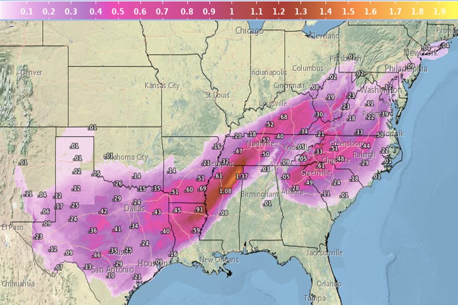
An unusually expansive and long-duration winter storm will bring heavy snow from the central U.S. across the Midwest, Ohio Valley, and\ through the northeastern U.S. for the remainder of the weekend into Monday. But this same storm system will also bring widespread heavy ice accumulation from the Southern Plains to the Mid-Atlantic and Southeast where crippling to locally catastrophic impacts can be expected.
An outbreak of arctic air from Canada interacting with widespread moisture well ahead of an upper-level low moving onshore into\ northwestern Mexico is currently producing an unusually expansive winter storm across the central to southern U.S. and into the Ohio Valley. The ascending dynamics on the southwestern flank of a strong jet stream across the northeastern U.S. will trigger the formation of a low pressure system across the Deep South on Sunday. By Sunday morning, this weather pattern will create an unusually expansive swath of moderate to heavy snow that will stretch from the south-central Plains through the Midwest and Ohio Valley, crossing the central Appalachians, and through the northern Mid-Atlantic states.
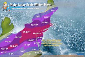
South of this long swath of impactful snow, an unusually expansive stretch of heavy sleet and freezing rain is forecast to impact the interior section of the southern Plains across the Arklatex and through the Tennessee Valley through Sunday afternoon. The heavy sleet and freezing rain will also impact many areas of the East Coast as far south as Atlanta, Georgia through interior Mid-Atlantic, as far north as New Jersey, New York City and possibly the southern coast of New England. Sleet accumulations of 1-3 inches coupled with narrow swaths of possibly an inch or more of ice accumulation would result in crippling to locally catastrophic impacts across portions of the South, interior Southeast into the Mid-Atlantic through Sunday.
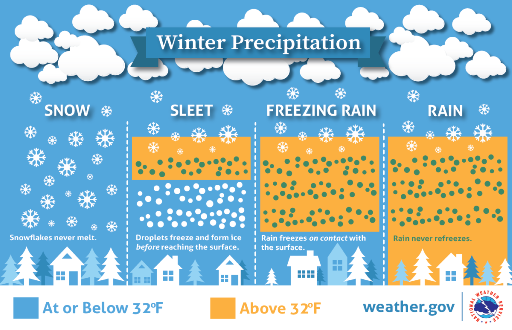
Freezing rain forms when snow falls through a warm layer of air aloft, melting into rain, then passes into a shallow layer of sub-freezing air near the ground, becoming “supercooled” liquid droplets that freeze instantly on contact with cold surfaces, creating dangerous glaze ice. It looks like normal rain but sticks and freezes, coating everything in ice, unlike sleet which freezes before hitting the ground.
The ice will be especially thick across northern Louisiana and Mississippi, southern Arkansas, and central Tennessee. In some places, ice could accumulate more than an inch thick.
Just a light glaze of freezing rain can be hazardous, but anything more could be catastrophic. As little as 0.25 inches (a quarter-inch) of ice accumulation from freezing rain is enough to begin damaging trees and snapping power lines, leading to power outages. When accumulation reaches 0.5 inches or more, the effects become severe, leading to widespread, long-lasting power outages and major structural damage to utility poles and lines.
The more ice, the more catastrophic it gets. With 0.10–0.25 inches of ice, trees and power lines get coated causing minor, isolated outages. With 0.25″ of ice, significant weight is added to lines, causing them to sag or snap, while also breaking tree branches. A quarter-inch of ice can add 100–500 pounds of weight to a single power line span, forcing it to snap or split. When 0.5″ of ice falls, there are widespread power outages and severe damage. At this level, a span of power lines can gain roughly 1,000 pounds of extra weight making it no match for the weight of the ice. When there’s 0.75″ or more of ice, not only do wires snap, but utility poles, power towers, and other pieces of electrical infrastructure can’t handle the loads and collapse.
After the ice storm, Arctic air will pour further down the Great Plains into the Gulf Coast and begin to rush into the entire East Coast on Monday behind the low pressure system. Below freezing temperatures are forecast to reach as far south as Brownsville, Texas with as low as below zero readings across the Texas Panhandle and into Oklahoma Monday morning. These bitterly cold temperatures will be at record breaking levels across the entire southern Plains beginning Sunday morning and especially Monday morning. These record cold temperatures will also combine with brisk northerly winds to produce dangerously cold wind chills.
Due to the presence of cold air, any ice that falls this weekend will be difficult to melt away.
