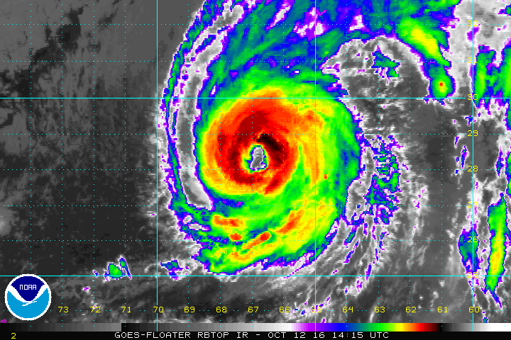
Hurricane Nicole went through a period of rapid intensification today, blossoming into a Category 4 Major Hurricane. The storm is expected to make a direct hit onto Bermuda Thursday and could potentially be the most violent storm to ever strike the island. The last Category 3 hurricane to come close to hitting Bermuda was in 2003 when Hurricane Fabian’s eye wall brushed along the island, killing 4 people and causing more than $300million in damages. Prior to that, the worst storm to strike Bermuda was an unnamed storm in 1926.
A Hurricane Warning is in effect for Bermuda now; this means that hurricane conditions are expected somewhere within the warning area. Preparations to protect life and property should be rushed to completion.
In their 11p advisory, the National Hurricane Center had Major Hurricane Nicole at latitude 30.1 North, longitude 66.4 West. The hurricane is moving toward the north-northeast near 12 mph. An increase in forward speed is expected Thursday followed by a northeastward turn and an additional increase in forward speed on Thursday night. On the forecast track, the core of Hurricane Nicole will pass near or over Bermuda on Thursday.
Maximum sustained winds are at 130mph with gusts to 160mph. Some additional strengthening is possible tonight or early Thursday and Nicole is forecast to be at or near major hurricane strength when it approaches Bermuda.
Hurricane-force winds extend outward up to 65 miles from the center and tropical-storm-force winds extend outward up to 160 miles . The estimated minimum central pressure is 956 mb (28.23 inches).
Many threats exist on Bermuda. Tropical storm conditions battering Bermuda tonight will increase to hurricane conditions in the morning. A dangerous storm surge will raise water levels by as much as 6 to 8 feet above normal tide levels in Bermuda. The surge
will be accompanied by large and destructive waves. Nicole is expected to produce total rain accumulations of 4 to 8 inches over Bermuda through Thursday which will create flooding conditions. Tornadoes are also possible on Bermuda tonight and Thursday. Everyone on the island should be inside a sturdy structure away from the coast.
The last significant hurricane to impact Bermuda head-on was Category 2 Hurricane Gonzalo in October of 2014. That storm made landfall on the southwestern coast and brought roughly 12 hours of hurricane-force winds to the island. In Gonzalo, winds peaked at 144mph at St. David’s Island, producing extensive roof and structural damage. At the height of the storm, about 31,000 out of 36,000 electricity customers are without power. While the damage toll came in at approximately $400million, there were no deaths or major injuries.
No direct impacts are expected to the US east coast from this storm, although rough surf and rip tides are likely to linger for several days from a very rough Atlantic. In Wallops Island, Virginia, a rocket launch scheduled to deliver supplies to the International Space Station has been delayed; the mission’s tracking station is located on Bermuda.