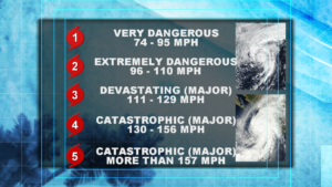
Sometimes simpler is better when it comes to communicating weather information to the general public.
The Saffir-Simpson Wind Scale (formally the Saffir-Simpson Hurricane Scale) is no exception to that and has gone through a few changes since it began widespread use in 1974. There is no doubt that hurricanes are massive complex weather systems that can cause great devastation when making landfall. Wind damage, storm surge, coastal flooding and inland flooding are a few of the many hazards experienced wherever a storm makes landfall. Trying to communicate a scale for all of these components can and has proven difficult in the past but none the less still needs to be communicated to the public as a storm is approaching. This was problem with the previous version of the Saffir-Simpson scale, addressing flooding and storm surge estimates with each category. As of 2010 the scale now only includes sustained wind speeds with each category and no longer gives flooding and storm surge information. The result is a simple and straightforward scale used to track and alert the public of the dangers of a developing or approaching storm.
So why was the storm surge estimate removed from the original scale and what has been done to compensate for that when warning the public? Storm surge after all is one of the biggest hazards of a hurricane. The National Hurricane Center defended removing the storm surge estimate due to the fact that the information was scientifically inaccurate. As we said before, hurricanes are complex weather systems, but what is equally as complex is how they interact with different land masses. Trying to group a storm surge estimate into a storm without taking into account the type of land that storm is about to impact was leading to major differences with the surge forecast vs the actual forecast. At times lower category storms were producing higher surges than higher category storms.
To deal with the lack of storm surge estimate in the new scale a different type of model was developed. The Sea Lake and Overland Surge from Hurricanes (SLOSH) takes into account a wide range of variables and produces detailed storm surge predictions for certain areas expected to experience a storm surge. While the previous scale grouped a storm surge estimate with a certain wind speed, the slosh model looks at a storms pressure, speed, size, forecast track and wind to make a surge forecast. This can give emergency managers and planners a better more detailed forecast of exactly where significant storm surge will be depending on that exact storm.
Civil Engineer Herbert Saffir and Meteorologist Robert Simpson developed the scale in 1971 in an effort to simplify communicating the forecasts to the public. It has and will continue to accomplish that but it is not perfect. Like every aspect of weather forecasting there can be improvements made with continued observation. Storm categories will continue to provide a simple and easily understood description of a storm’s intensity, doing exactly what Saffir and Simpson set out to do.