• Skip to primary navigation
  • Skip to main content
  • Skip to primary sidebar

Weatherboy

Weatherboy Weather News, Maps, RADAR, Satellite, and Forecasts.

  • Local
  • Earth Science News
  • RADAR
  • Current Warnings
  • Satellite
  • Current Maps
  • Forecast Maps
  • Video

Climate Prediction Center Updates Winter Outlook

by Weatherboy Team Meteorologist - October 17, 2025

The latest seasonal temperature outlook calls for above normal temperatures for much of the lower half of the continental United States. Image: NOAA CPC

NOAA’s Climate Prediction Center (CPC) has released their latest winter outlook for the months of December-January-February; in it, it reflects the impacts of what is expected to be a season influenced by La Nina.

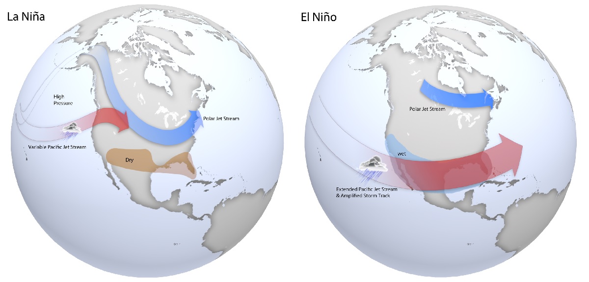
The La Nina weather pattern is a function of ENSO. ENSO, short for El Nino Southern Oscillation, is a recurring climate pattern involving changes in the temperature of waters in the central and eastern tropical Pacific Ocean. On periods ranging from about three to seven years, the surface waters across a large swath of the tropical Pacific Ocean warm or cool by anywhere from 1°C to 3°C, compared to normal. This oscillating warming and cooling pattern, referred to as the ENSO cycle, directly affects rainfall distribution in the tropics and can have a strong influence on weather across the United States and other parts of the world. El Niño and La Niña are the extreme phases of the ENSO cycle; between these two phases is a third phase called ENSO-neutral.

CPC expects La Nina to have a dominant role in the climate pattern for the upcoming winter season.

Typical late fall through early spring upper level jet stream positions associated with moderate to strong La Niña (left) and El Niño (right) events. During La Niña, a variable Pacific jet stream in association with a polar jet stream shifted further south favors below normal precipitation across the southern US, with below normal temperatures across the northern US. During El Niño, a strong and amplified Pacific jet stream extending across the southern US in association with a polar jet stream shifted further north into Canada favors above normal precipitation across the southern US, and above normal temperatures over the northern US. Image: NOAA


Based on the latest outlook from the CPC, La Nina will help keep California, Nevada, and the rest of the southwest milder than usual; the same is true across the Gulf Coast and much of the eastern U.S. into southern New England. Only in northern Montana, North Dakota, and portions of northern Minnesota are temperatures expected to be below normal levels.

The latest seasonal precipitation outlook calls for above normal precipitation in some northern states and drier than usual conditions for some southern and eastern states. Image: NOAA CPC


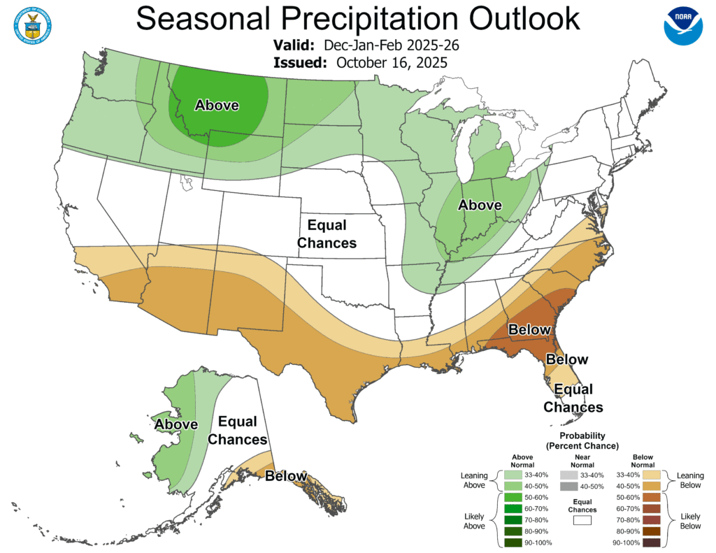
When it comes to precipitation, the CPC also says La Nina will impact rain and snow fall across portions of the United States this December, January, and Feburary. In that time, below normal precipitation is likely along the southern states, especially in the southeast north of central Florida.  Above normal precipitation is expected across the Ohio and mid Mississippi Valley and much of the northern states away from New England. The greatest chance of above normal precipitation during the winter months is in Montana.

The NOAA’s Climate Prediction Center issues climate outlooks on different frequencies, including: daily for short-term forecasts (8-14 days), monthly for one-month and three-month outlooks (released twice a month), and seasonally around mid-month for three-month outlooks. A new one-month outlook is issued on the third Thursday of each month and updated on the last day of the month, while seasonal outlooks are released once a month near the middle. The outlooks continue to be released despite the ongoing government shutdown. 

Primary Sidebar

Sponsored Ad

Search

Latest News

  • Climate Prediction Center Updates Winter Outlook
  • Company Proposes Selling Daylight on Demand
  • Lorenzo Dissipates Leaving the Atlantic Free of Any Tropical Threat
  • Overnight Earthquake Rattles New York Again
  • Cruise Ship with 9,000 Souls On-Board Trapped in Nor’Easter at New Jersey
  • Major Coastal Flooding & Wind Damage Likely Today from Nor’Easter
  • Weaker Nor’Easter Scenario Likely, But Major Impacts Still on the Table
  • New Data Suggests Nor’Easter for New Jersey & New York May Not Be As Severe As Initially Thought
About | Careers | Contact | Contests
Terms | Privacy | Ad Choices
Weatherboy is a (R) Registered Trademark of isarithm LLC, All Rights Reserved.
All content herein is Copyright by Isarithm LLC 1997-2022