Major coastal flooding and some wind damage at the coast is likely today from a nor’easter moving up the Mid Atlantic coast. The worst impacts will be over Delaware Beaches and the Jersey Shore where coastal flooding will be at its worst and the potential for gusts of wind over 50 mph will be their highest. While coastal flooding and wind damage will be problematic, widespread fresh water flooding from heavy rain is no longer expected.
With the storm less severe and tracking more east than west, the heaviest rainfall will fall over the ocean from this storm. As such, most places will see an inch or less of rain across the Mid Atlantic and Northeast, with only the immediate coastal area seeing an inch and a half or more.
As of early this morning, a primary surface low was positioned off the South Carolina coast. A secondary low was starting to develop closer to Cape Hatteras, and this low will be the main impact on the Mid Atlantic. This low will strengthen as it heads northward, eventually stalling just off the Jersey Shore before starting to weaken and move away Monday night and beyond.
As the pressure gradient tightens on its northwestern flank, a low level easterly jet will intensify, with winds likely gusting up to 60 mph near the immediate coast and 50 mph across interior coastal New Jersey and Delaware. Further inland, the jet dwindles markedly, with only gusts of 30-40 mph in Philly and even lower further inland. Strongest winds look to spread north along the coast starting in Delaware late this afternoon and continuing north to near Sandy Hook by late tonight before they begin to dwindle towards dawn Monday.
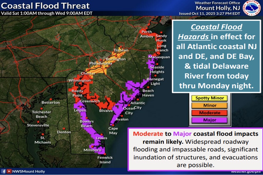
These strong winds will also drive water from the ocean onto land, setting the stage for a moderate to major coastal flooding threat. The impacts will begin today and last through Monday. According to the National Weather Service, guidance still varies in potential outcomes of this storm with regard to severity of coastal flood impacts locally. At this time, the greatest threat of impacts are anticipated to occur along the Atlantic coasts of New Jersey and Delaware, and Delaware Bay. A Coastal Flood Warning remains in effect for Sunday through Monday.
Severe beach erosion and dune breaching are quite possible along the entire New Jersey Shore and for Delaware Beaches due to the very high surf conditions that are expected.
“Interests along the Atlantic coast, Delaware Bay, back bays, and tidal waterways should remain alert for forecast updates regarding this significant coastal flood event,” warns the National Weather Service.
As the storm weakens and pushes east tomorrow, winds will relax, coastal flooding will subside, and skies will begin to clear.
