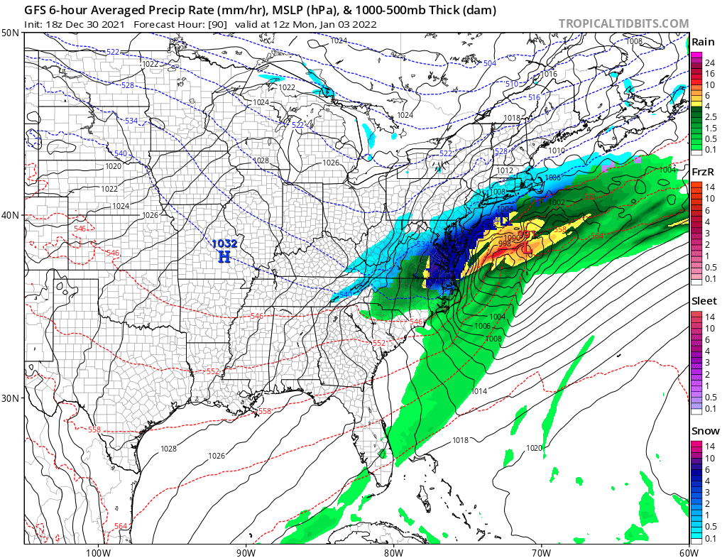
While winter has seen a slow start in portions of the eastern United States this year thus far, the American GFS and European ECMWF computer forecast models are suggesting a pattern change next week which could produce a significant winter storm with large snow accumulations. However, while both global forecast models suggest the chance of a winter storm, the timing and placement of the storm is very different between the two.
Today’s latest American GFS forecast model run suggests an area of low pressure will develop off of the Mid Atlantic coast, creating an area of heavy snow stretching from North Carolina to New Jersey on Monday. If it were to verify, more than 6″ of snow could fall over portions of southern New Jersey, most of Delaware, eastern Maryland, and northeastern Virginia. The GFS also suggests another storm system will come through the region later Wednesday into Thursday; however, that storm would follow a much milder storm track than the first. If that second storm verified, it would bring soaking rains up the entire coastal plain up into northern New England with scattered snow flurries and Lake Effect snows in its wake on Friday.
Today’s latest European ECMWF forecast model run suggests an entirely different scenario to the GFS. While it shows a coastal storm taking shape on Monday, it does so too far south and east to make a significant impact to the east coast. It also keeps conditions too mild for snow early in the week. However, unlike the GFS model, the ECWMF suggests the Thursday/Friday storm will be far more intense and colder, producing heavy snows in New England. If the ECMWF were to verify, more than 6″ of snow would fall across the northern 2/3rds of New York, northwestern Massachusetts, all of Vermont, and much of New Hampshire and Maine.
However, it remains to be seen if either forecast model is onto something. The GFS and ECMWF are among many computer models meteorologists use to assist in weather forecasting. While meteorologists have many tools at their disposal to create weather forecasts, two primary global forecast models they do use are the ECMWF from Europe and the GFS from the United States. While the models share a lot of the same initial data, they differ with how they digest that data and compute possible outcomes. One is better than the other in some scenarios, while the opposite is true in others. No model is “right” all the time. Beyond the ECMWF and GFS models, there are numerous other models from other countries, other academic institutions, and private industry that are also considered when making a forecast.
As 2021 wraps up, meteorologists will be pouring through observations and forecast data, including computer model data, to better understand what model run may be more right than the other for next week. While it is likely it’ll be stormy somewhere, it is simply too soon to tell who will get snow, how much, and when. Those details will be better understood by the coming weekend as 2022 begins.