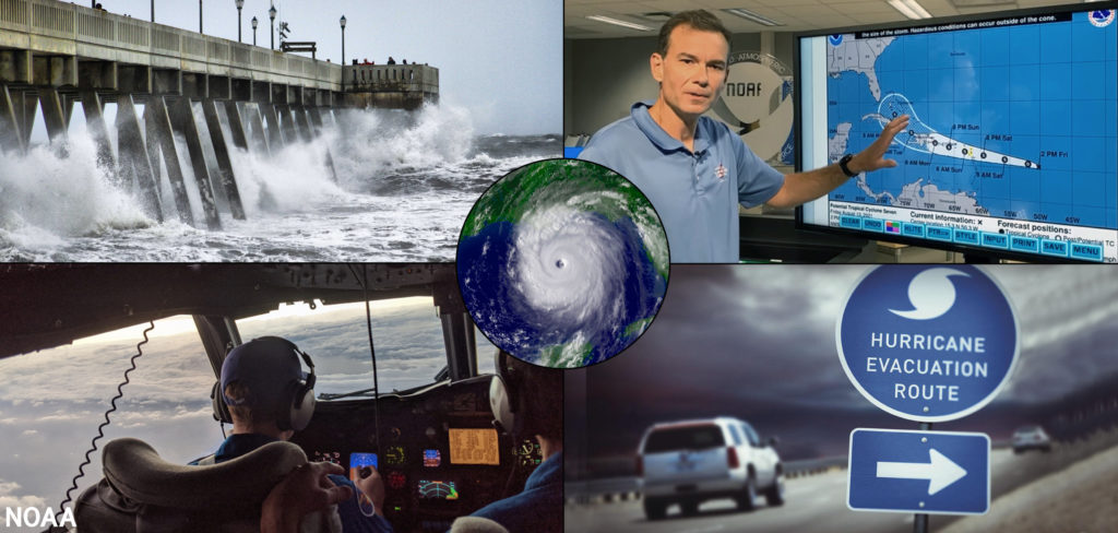
a Hurricane Hunter pilot flying into a storm. Image: NOAA
Tropical weather experts with Colorado State University’s (CSU) Tropical Meteorology Project and the National Oceanic and Atmospheric Administration (NOAA) have both released updated Atlantic Hurricane Season Outlooks, with each suggesting that an above-normal season will unfold in the weeks and months ahead, echoing what each seasonal outlook suggested when they were first issued earlier this year. However, while both continue to call for an above-normal season, both have slightly lowered their projections for the season that spans from June 1 through November 30.
Dr. Phil Klotzbach, who leads the CSU forecast endeavor, said, “While continuing to forecast an above normal Atlantic hurricane season, we have lowered our forecast slightly and call for 18 named storms, including the three named storms that have already formed, eight hurricanes and four major hurricanes. While the Atlantic season has been very quiet since early July, we do anticipate things to pick up around August 15-20.”

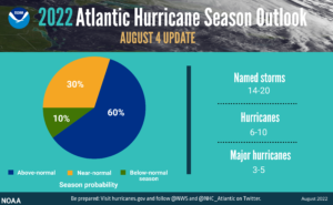
“We’re just getting into the peak months of August through October for hurricane development, and we anticipate that more storms are on the way,” said NOAA Administrator Rick Spinrad, Ph.D. In NOAA’s updated outlook released today, the number of named storms initially forecast to be 14-21 was tweaked down to 14-20; the odds of an above-normal season shifted from 65% down to 60%. Even with the slight changes, NOAA forecasters still believe an especially active season is on the way.
“I urge everyone to remain vigilant as we enter the peak months of hurricane season,” said Secretary of Commerce Gina Raimondo. “The experts at NOAA will continue to provide the science, data and services needed to help communities become hurricane resilient and climate-ready for the remainder of hurricane season and beyond.”

According to NOAA, there are several atmospheric and oceanic conditions that still favor an active hurricane season. This includes La Niña conditions, which are favored to remain in place for the rest of 2022 and could allow the ongoing high-activity era conditions to dominate, or slightly enhance hurricane activity. In addition to a continued La Niña, weaker tropical Atlantic trade winds, an active west African Monsoon and likely above-normal Atlantic sea-surface temperatures set the stage for an active hurricane season and are reflective of the ongoing high-activity era for Atlantic hurricanes.
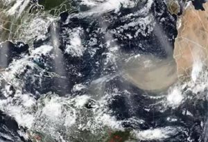
Present over the Atlantic Ocean now is an area of dry, dusty air that blew-in from the Sahara Desert region of Africa; however, NOAA forecasters say the dust doesn’t play a significant role in their seasonal outlooks.
We asked Matthew Rosencrans, lead hurricane season outlook forecaster at NOAA’s Climate Prediction Center, what role, if any the presence of dust has in the seasonal outlook. Rosencrans said the amount of dry, dusty air coming into the Atlantic usually peaks in mid to late July, well ahead of when the bulk of Atlantic tropical cyclone activity typically forms in September. “The dust is not a factor in the seasonal forecast,” Rosencrans told us, adding that the dust is “such a small portion of the predictability of the seasonal signal.”

While the dusty, dry layer has been present in recent weeks, Rosencrans said it hasn’t been a factor in this year’s Atlantic Hurricane Season. “While dust can tamp down on formations of tropical cyclones….we have not had that interplay this year,” Rosencrans explains, saying that while dust can impede cyclone formation when strong waves run into it, that hasn’t been the case this year.
Rosencrans says other factors are stronger drivers of activity in the Atlantic; CSU forecasters agree.
“Sea surface temperatures averaged across the tropical Atlantic are slightly warmer than normal, while subtropical Atlantic sea surface temperatures are cooler than normal,” said CSU in their updated outlook out this week. “Vertical wind shear anomalies averaged over the past 30 days over the Caribbean and tropical Atlantic are slightly weaker than normal. Current La Niña conditions are likely to persist for the rest of the Atlantic hurricane season. We continue to anticipate an above-normal probability for major hurricanes making landfall along the continental United States coastline and in the Caribbean.”
“As is the case with all hurricane seasons, coastal residents are reminded that it only takes one hurricane making landfall to make it an active season for them,” the CSU updated outlook warns. “They should prepare the same for every season, regardless of how much activity is predicted.”
“Although it has been a relatively slow start to hurricane season, with no major storms developing in the Atlantic, this is not unusual and we therefore cannot afford to let our guard down,” said FEMA Administrator Deanne Criswell. “This is especially important as we enter peak hurricane season—the next Ida or Sandy could still be lying in wait.