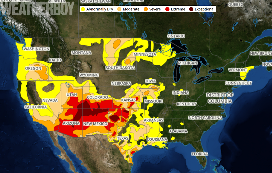
In today’s Drought Monitor map update, the wet weather pattern has nearly erased all idea of drought off the eastern United States while the drought has worsened over portions of the Rockies. The U.S. Drought Monitor map provides a summary of drought conditions across the United States and depicts areas experiencing agricultural or hydrological drought impacts. These impact indicators help communicate whether short- or long-term precipitation deficits are occurring.
Since last week’s update, dry conditions continue to persist in portions of the Desert Southwest and parts of the Rockies, leading to drought conditions continuing or worsening there. Farther east across the Great Plains, rain from scattered thunderstorms led to some areas improving or staying out of drought, while areas that missed out on the rain saw conditions become more dry. The same was true across the Upper Midwest and Northern Plains; areas that were able to see rain in the last week saw improving conditions while those that missed out on the shower and storm activity worsened. With an unusually wet weather pattern locked-in over much of the eastern United States, drought conditions have disappeared from the map. While there are some dry conditions along the central New England coastal area, they are not considered to be near drought level concerns.
The worst of the US’s drought concerns is over southeastern Utah, southern Colorado, northeastern Arizona, northern Mexico, northern Texas, and parts of west-central Oklahoma. In these areas, efforts to conserve water should be made.