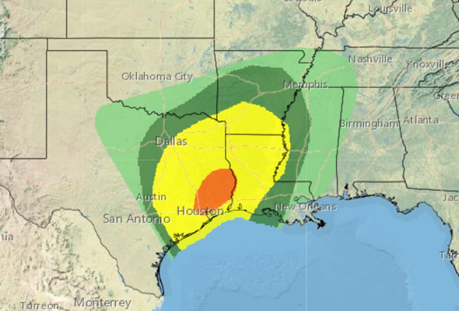
A Boxing Day severe weather outbreak is likely in Texas, especially near and to the north and east of the Houston metro area. The National Weather Service’s Storm Prediction Center has issued an Enhanced Risk for severe weather across Southeast Texas in their latest Convective Outlook. This includes a potential for strong tornadoes (EF-2 or higher), with the threat beginning in the early afternoon and continuing into the evening. Residents are advised by the National Weather Service to stay informed and be prepared for severe weather conditions including damaging winds up to 70 mph and large hail.
A Tornado Watch has been issued for the entirety of southeast Texas minus Jackson and Matagorda Counties. This Watch will continue through 7 pm. Scattered thunderstorms continue this afternoon across the area. Surface observations show dew points increasing to around 70F along and south of the I-10 corridor, suggesting that this area now lies in the warm sector as a warm front lifts northward.
In advance of a mid-upper trough, a surface low pressure area will develop in northwest Texas and track east-northeast toward the ArkLaTex today. A strengthening low level jet will transport deeper Gulf moisture into the region with abnormally high moisture content arriving for this time of year. Scattered showers from early this morning will transition into thunderstorms and increase in areal coverage late this morning and afternoon with daytime heating and the approach of various atmospheric dynamics which are expected to trigger the bad weather.
There is a threat of severe weather across all of southeast Texas today. That being said, latest guidance seems to point toward areas along and east of a line from roughly Madisonville-Freeport possibly having the overall most favorable set-up.
“Not everyone will see severe storms, but those that do…some
significant impacts are not out of the question,” the Houston office of the National Weather Service warns.
Many hazards exist today:
– Tornadoes: environment will become favorable for discrete rotating storms especially late morning to late afternoon.
– Hail: cooling mid levels of the atmosphere will enhance updraft strength and hail growth zone. Hail larger than quarter size will be likely in the stronger cells.
– Wind damage: strong winds aloft will be prone to mix to the surface in and near storm downdrafts.
– Heavy rain/flash flooding/rivers: deep moisture is forecast to be in place as will a somewhat favorable set-up for some storm training. Several inches of rain could fall in a short time period leading to some localized issues. Most of the area saw 1-4″ of rainfall yesterday which should limit how much the ground can absorb. Should any storms train over locations that saw the most significant rains, runoff is more prone to lead to some street flooding. Though widespread river problems are not anticipated, there could be rises on some watersheds.
– Hazardous marine conditions: similar to the above…hail, wind gusts greater than 34 kts, and waterspouts will be a possibility. The risk probability will be higher east of Sargent.
Prevalent discrete storms prior to around 5pm should transition to a more linear mode as the surface front makes its way toward the US59-
I69 corridor late in the day. A thin band of storms will probably continue southeastward and off the coast sometime around 9pm. By late tonight, the storm activity should die down with the severe weather threat passing before midnight.
