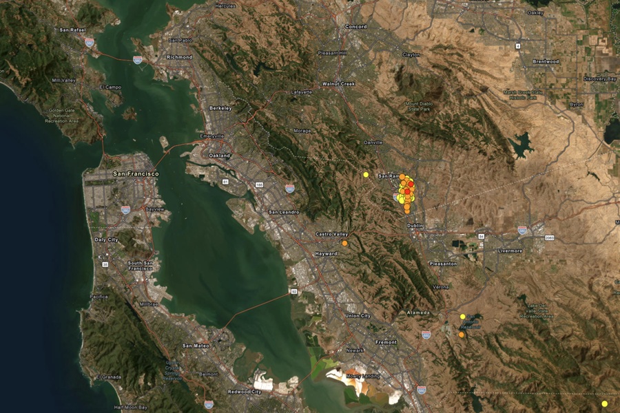
An earthquake swam appears to be building near San Francisco just as the region prepares to host Superbowl LX. This year’s Super Bowl will be held at Levi’s Stadium in Santa Clara, which is the home of the San Francisco 49ers. But in the last 7 days according to USGS, there have been 115 earthquakes in the area, almost all centered near San Ramon which is just 25 miles due north of the stadium. There have been 23 just in the last 24 hours alone.
Super Bowl week kicked off with a shaky start on Monday morning, with a magnitude 4.2 earthquake hitting the area. While there were no reports of major damage or serious injuries, residents and guests arriving early for the Super Bowl felt it and several others. There were dozens of earthquakes in the 45 minutes before and after that 7:01 am earthquake on Monday, with dozens more striking the same general area since.
This ongoing earthquake swarm in recent days and weeks have put some in California around the San Francisco area on edge, alarmed that the “Big One” may be coming. Recent large earthquakes in Japan and Alaska are adding to the fear that a significant earthquake could soon strike California. USGS says the odds of a larger earthquake striking are high, although those odds are over an extended period of time and not necessarily over the short-term next few days or weeks.
Earthquakes, San Francisco, and major sporting events have crossed paths before in the past. A 6.9 magnitude Loma Prieta earthquake interrupted Game 3 of the 1989 World Series on October 17, 1989. It struck at 5:04 pm shortly before the San Francisco Giants and Oakland Athletics were set to play at Candlestick Park, making it the first major earthquake to be broadcast live on television. That earthquake killed 63 people and injured 3,757 people around the Bay Area.
Scientists know there’s an elevated risk of earthquake activity in the region, but are unable to forecast when more earthquakes will occur or if the “Big One” will strike.
The “Big One” in California refers to a major earthquake, likely magnitude 7.8 or higher, expected along the San Andreas Fault, potentially causing widespread destruction, significant loss of life, and massive economic damage to California. Scientists say there is a high probability of such a large earthquake striking the state in the coming years, putting odds at 72% that a magnitude 6.7 or greater earthquake will strike the broader Bay Area between now and 2043. Unfortunately, scientists with USGS say that with modern technology and earthquake forecasting, they cannot narrow down the window to determine when such a large scale disaster will strike.
But because scientists stress it’s a matter of “when, not if”, ongoing moderate earthquake swarms near the Bay Area along with headline-generating large earthquakes elsewhere in the world have the region on edge.
According to USGS, earthquakes with a magnitude of 2.0 or less are rarely felt or heard by people, but once they exceed 2.0, as many of these events did, more and more people can feel them. While damage is possible with magnitude 3.0 events or greater, significant damage and casualties usually don’t occur until the magnitude of a seismic event rises to a 5.5 or greater rated event.
According to USGS, a swarm is a sequence of mostly small earthquakes with no identifiable mainshock. “Swarms are usually short-lived, but they can continue for days, weeks, or sometimes even months,” USGS adds.
Experts say these “seismic swarms” are not unusual. Similar patterns occurred in 2002, 2003, and 2015 along the Calaveras Fault, part of the larger San Andreas and Hayward fault system. While these smaller quakes may relieve some stress, they don’t eliminate the risk of a major event.
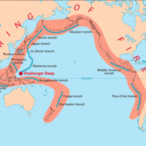
However, with other areas experiencing “big ones”, there’s concern by some that these swarms are a precursor to a big one in California. One large earthquake hit Alaska on December 6 with a magnitude of 7.0, the second, a 7.6 magnitude “mega-quake”, hit northern Japan on December 8, prompted tsunami advisories across a broad area. While not directly linked to each other, California, Alaska, and Japan earthquakes have one thing in common: they’re all located around the “Ring of Fire.”
The Ring of Fire is a string of ongoing seismic and/or volcanic activity around the edges of the Pacific Ocean. Roughly 90% of all earthquakes occur along the Ring of Fire, and the ring is dotted with 75% of all active volcanoes on Earth. The Ring of Fire is the result of plate tectonics; plates on the Earth’s surface are constantly moving atop a layer of solid and molten rock called the mantle. Sometimes these plates collide, move apart, or slide next to each other; in these areas, like the Ring of Fire, earthquake and volcano activity is abundant.
