Meteorologists at the National Hurricane Center (NHC) in Miami, Florida are monitoring a disturbance they expect to eventually become a tropical cyclone in the central Atlantic. While Hurricane Erick’s outer bands will begin to impact Hawaii tonight with heavy rain, the rest of the U.S. has been quiet as it relates to tropical cyclone activity. With August here, that appears to be changing, with the NHC calling for a 70% chance of tropical cyclone formation here.
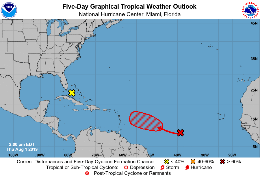
The area of concern is half way between Africa and South America, an area that becomes more favorable for tropical cyclone development this time of year. A broad low pressure system located about 1,100 miles west-southwest of the Cabo Verde Islands is producing limited shower and thunderstorm activity. According to the NHC, slow development of this system is expected during the next few days while it moves west-northwestward at 10 to 15 mph. Additionally, the NHC expects a tropical depression to form from it several hundred miles east of the Lesser Antilles. The NHC believes there’s only a 20% chance of tropical cyclone formation in the next 48 hours, but does increase that to 70% over the next 5 days.
A tropical cyclone is a rapidly rotating storm system characterized by a low-pressure center, a closed low-level atmospheric circulation, strong winds, and a spiral arrangement of thunderstorms that produce heavy rain. A tropical wave that becomes a Tropical Depression is considered to be a tropical cyclone. From there, as the tropical cyclone becomes better defined and more intense, it is referred to as either a Tropical Storm or a Hurricane depending on its intensity.
While tropical cyclone formation is likely with this storm system in the Atlantic, it is too early to know how it’ll evolve as it approaches the Caribbean and the United States east coast. Overnight, computer forecast guidance suggested impacts from Florida to New England from what it projected to be a significant hurricane. However, afternoon guidance has since downplayed such a threat, suggesting the storm will be swept out to sea due in part to a cold front moving across the country. Either way, people in the Caribbean and the U.S. East Coast should keep a watchful eye on this system early next week as it continues a westward march.
The National Hurricane Center has also been monitoring a disturbance near Florida. An area of disturbed weather spreading across south Florida and the Bahamas is forecast to move northward, producing additional locally heavy rainfall over portions of the Florida peninsula during the next day or two. According to the NHC, significant development of this system is not expected before it merges with a front and accelerates northeastward off the southeastern U.S. coast on Sunday. As such, the NHC says there’s no chance of tropical cyclone formation from this system at all over the next 5 days.
Hurricane season continues through to the end of November.
