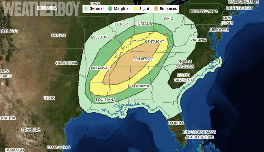
A vigorous storm system threatens to bring severe weather to portions of the southeast for Monday into Tuesday; on Wednesday, the severe threat will march east towards the close, threatening portions of the I-95 corridor then.
Severe storms capable of damaging winds and tornadoes are expected mainly Monday evening and overnight from northern Mississippi across Tennessee and into central Kentucky. Within a broad area of cyclonic flow aloft across the continental US, a shortwave trough will move from the ArkLaTex Monday afternoon northeastward across the Ohio Valley during the night. This wave will take on a negative tilt, with the greatest height falls and the greatest cooling aloft from northern Arkansas into Ohio while height tendencies remain neutral overnight across the Gulf Coast states. Winds aloft will continually increase through the period, with strong large-scale lift mainly from Tennessee northward toward the Great Lakes. At the surface, a broad area of southerly winds will allow a northward return of 60s F dewpoints from eastern Texas into the lower Mississippi Valley during the day, and into Tennessee and Kentucky overnight. This will aid in gradual destabilization which when combined with very strong shear profiles will support the potential for corridors of damaging severe storms.

On Tuesday into Wednesday, a few strong to severe storms with locally strong wind gusts and perhaps a couple of tornadoes will be possible from a portion of the Southeast States to the Middle Atlantic region. Showers and thunderstorms will be ongoing along and just ahead of a cold front from the Ohio Valley into the Gulf Coast states with an ongoing modest risk for isolated damaging wind. A surface low will shift from the Ohio Valley into the lower Great Lakes as the attendant shortwave trough advances northeast. Some of the thunderstorms may weaken/dissipate as they cross the Appalachians. Redevelopment may occur, especially from the central/eastern Carolinas into the eastern Middle Atlantic during the afternoon where greater destabilization is possible in association with northward advection of richer low-level moisture. The kinematic environment will support organized convection along and ahead of the cold front. However, widespread clouds and weak instability will probably serve as overall limiting factors for a more robust severe threat.
Those heading out to election polls should do so as early as possible. Afternoon heating will trigger the most number of thunderstorms and severe weather threats.
For specific weather forecasts for your zip code, visit our local weather page here.