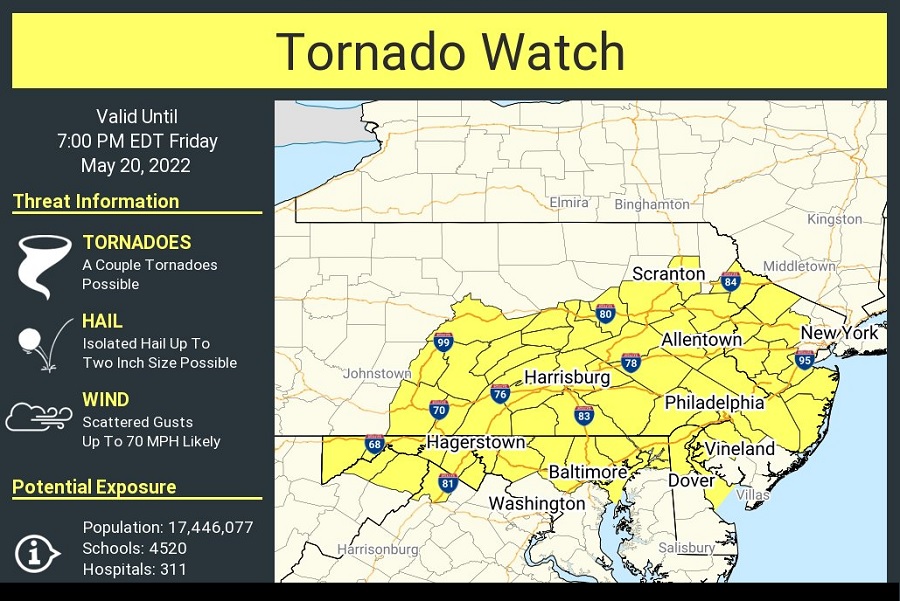
Due to the elevated risk of tornadoes forming from severe thunderstorms developing in the Mid Atlantic this afternoon and evening, the National Weather Service has issued a Tornado Watch for portions of Pennsylvania, Maryland, New Jersey, and Delaware. The cities of Philadelphia and Baltimore are both included in this Tornado Watch box. The Tornado Watch is in effect through 7pm tonight; more than 17 million people are contained within the watch box. In addition to the risk of tornadoes, there’s risk of damaging straight-line winds in excess of 70 mph, large hail up to 2″ in diameter, and isolated flash flooding from sudden downpours.
According to the National Weather Service’s Storm Prediction Center, thunderstorms are increasing over western Pennsylvania. This activity will track rapidly eastward across the watch area today, posing a risk of damaging winds and a few tornadoes. The tornado watch area is approximately along and 60 statute miles north and south of a line from 15 miles west southwest of Altoona, Pennsylvania to 15 miles south of Newark, New Jersey.
The National Weather Service will issue a Tornado Watch when conditions are favorable for tornadoes and severe thunderstorms in and close to the watch area. “Persons in these areas should be on the lookout for threatening weather conditions and listen for later statements
and possible warnings,” the National Weather Service said in a Tornado Watch bulletin issued moments ago.
While not everyone will see tornadoes or even severe thunderstorms, the expected coverage area of forecast storms and their severity was enough for the National Weather Service to issue the Watch.
Today’s severe weather outbreak is being triggered by both a warm front and a mid level disturbance which is tracking across the Mid Atlantic. As this warm front moves through, an exceptionally strong Bermuda High Pressure system will build in, setting the stage for record or near-record warmth across portions of the Mid Atlantic and Northeast tomorrow into Sunday.
