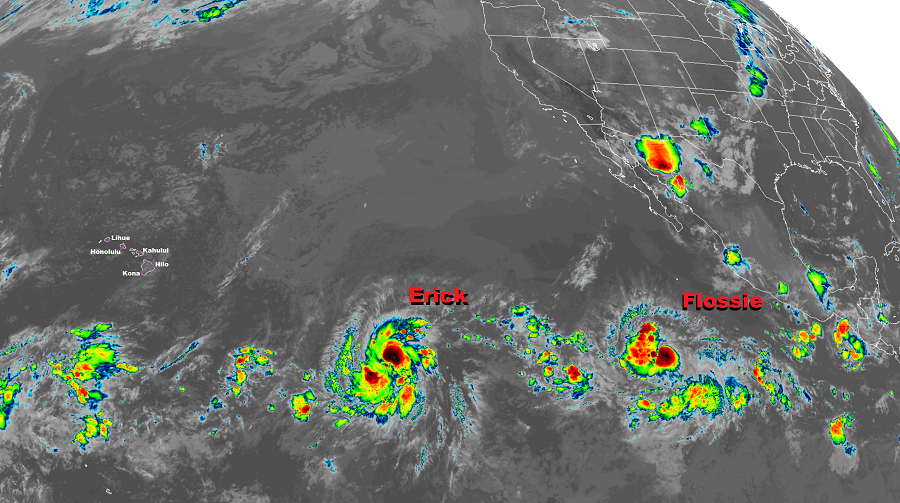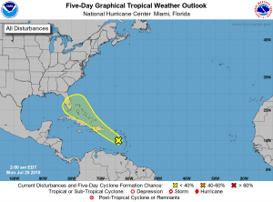
The National Hurricane Center (NHC) upgraded Tropical Depression 7E to Tropical Storm Flossie this morning ; it joins Tropical Storm Erick on inching closer to Hawaii. Meanwhile, the National Hurricane Center is also monitoring an area in the Atlantic hurricane basin that has a slight chance of developing into a tropical cyclone this week.
In the latest update from the NHC, Tropical Storm Flossie’s center was located near latitude 12.5 North, longitude 113.0 West. Flossie is moving toward the west near 20 mph and this general motion is expected to continue for the next few days with a slight decrease in forward speed. Maximum sustained winds are near 40 mph with higher gusts. The NHC expects Flossie to go through a period of gradual strengthening, with Flossie projected to be a hurricane by tomorrow or tomorrow night. For now, tropical storm force winds extend outward up to 80 miles from the center while the estimated minimum central pressure is 1005 mb or 29.68 inches.
While Flossie is on target to be a hurricane tomorrow, Erick should reach that status later today. In the latest advisory from the NHC, the center of Tropical Storm Erick was located near latitude 11.7 North, longitude 134.5 West. Erick is moving toward the west near 16 mph, and this motion is expected to continue through Monday. A turn to the west-northwest and a slower forward speed is expected to start on Tuesday and continue through Wednesday. Maximum sustained winds have increased to near 70 mph with higher gusts, making it just a few miles per hour shy of hurricane status. Rapid strengthening is forecast by the NHC during the next 48 hours, with Erick likely becoming a major hurricane by tomorrow. A weakening trend is then forecast by the NHC to begin by late Wednesday. Erick’s estimated minimum central pressure is 995 mb or 29.39 inches now.
Global computer forecast guidance, including the American GFS model and European ECMWF model, each predict indirect and direct impacts from these storms on Hawaii as soon as the end of this work week. Erick will be the first to approach the islands by Friday, with Flossie approaching 4-5 days later.
At this time, it appears Erick will weaken to a tropical storm as it nears Hawaii; it also appears likely the center of circulation will pass well south of the Aloha State. However, a large moisture field associated with this disturbance is likely to produce heavy rain over portions of Hawaii, with the heaviest rain expected on the eastern half of Maui and Hawaii counties. Flooding rains are possible, along with the threat of rock and mud slides. While conditions may become breezy, damaging wind gusts will be restricted to the highest terrain of Hawaii Island, with Mauna Kea and Mauna Loa expected to see high wind gusts. At the coast, rough surf, rip tides, and some coastal flooding will be possible as the system moves well south of Hawaii.
As early as the following Tuesday, Flossie could hit Hawaii’s Big Island head-on as a strong tropical storm or minimal hurricane. While the storm system will likely arrive in Hawaii in a weakening state, very heavy rain and gusty winds are possible for a large part of the state, with Maui and Hawaii counties hit hardest. An additional 4-8″ rain or more could fall above/beyond what falls from Erick, creating additional flooding threats, along with rock and mud slide hazards. With Flossie expected to pass over or near Hawaii, winds will be gustier, with the highest winds again at Mauna Kea, Mauna Loa, and on the Hilo side of Saddle Road. Such winds could be dangerous at times, presenting damage to non-reinforced or temporary structures. As with Erick, Flossie will likely generate rough and high surf, rip tide currents, and coastal flooding.
Officials in Hawaii are urging people to have a Hurricane Action Plan well in advance of any specific tropical cyclone threat materializing. In addition, they’re urging people to stock-up on at least 2 week’s worth of supplies should supply routes and ports become interrupted or damaged from these storms.

While Hawaii is preparing for the possibility of two direct or indirect impacts from tropical cyclones, the Atlantic Hurricane Basin remains relatively quiet. However, showers and thunderstorms extending from the eastern Caribbean Sea to just north of the Leeward Islands are being monitored by the NHC for possible development. For now, they are associated with a tropical wave in the Caribbean. According to the NHC, this disturbance is expected to move west-northwestward to northwestward across the north-central Caribbean Sea during the next few days, producing locally heavy rainfall and possibly some flooding across portions of the Lesser Antilles, Puerto Rico, and Hispaniola. According to the latest NHC Tropical Outlook, little development of the disturbance is expected in the coming days as upper-level winds are forecast to become less conducive for development. However, as the system is moves near or over the Straits of Florida and the Bahamas by the end of the week, the NHC says environmental conditions could be a little more conducive for tropical cyclone development. For now, the odds of such development are low; the NHC says there’s only a 10% chance of formation over the next 48 hours and only a 20% chance over the next 5 days.