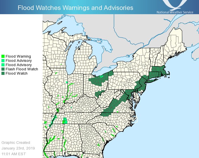
Another winter storm will shift across the Great Lakes into New England through Thursday. With milder air surging up the coast to Maine, heavy rain and thunderstorms will bring a threat for flooding from the northern Gulf Coast into southern New England. Due to this threat, the National Weather Service has issued a slew of flood watches and advisories for the eastern United States.
The most dominant advisory up now is a Flash Flood Watch. A Flash Flood Watch means that conditions may develop that lead to flash flooding. According to the National Weather Service, flash flooding is a very dangerous situation; they urge people to monitor later forecasts and be prepared to take action should flash flood warnings be issued.
Steady rain and milder temperatures are expected across a large part of the eastern U.S., and especially the northeast, on Thursday. The rain may be locally moderate to heavy at times. The combination of about one to two inches of rainfall, along with melting snow in the north, will allow for rises on rivers and streams. Some rivers may reach minor flood stage. In addition, the high rainfall rates may allow for minor flooding of urban, poor drainage and low lying areas. With the ground frozen in many areas, flash flooding will be possible since the ground won’t be able to absorb the additional moisture. In addition, isolated ice jams cannot be ruled out in portions of the Northeast on rivers as well, which may also result in flooding.
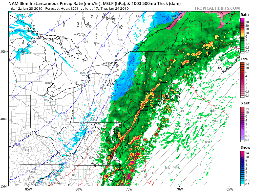
Responsible for this flood potential is yet another winter storm. An area of low pressure will move northeastward from the Great Lakes into Quebec through Thursday. A warm front associated with the system will cross the Mid Atlantic later today and tonight, followed by a cold front Thursday. As the cold front enters the Mid Atlantic, it is possible that a line of strong thunderstorms, or perhaps even a squall line, will form. Such a set-up could create localized flash flooding, or at the very least, ponding on roadways. Motorists are advised to drive with care and caution. The National Weather Service also reminds people to “turn around, don’t drown; never drive through flood waters.”
High pressure will then build into the East on Friday and Saturday. A developing area of low pressure near the Great Lakes and southeastern Canada will pull a cold front through to the Mid Atlantic on Sunday. It’s possible a coastal low will form along this front early next week. While computer forecast models suggested that a robust snowstorm would form late Sunday/Monday from the Great Lakes system and a merging coastal storm, it is very unlikely such a scenario would unfold at this time.
