The Bering Sea Rule (BSR) has proven to be an invaluable tool for making medium to long range weather forecasts. However, in the world of meteorology, there is no perfect tool that can clearly forecast well into the future with precision. And the BSR is no exception.
While using the BSR accurately depicted the arrival of the Blizzard of 2017, it inaccurately saw a significant warm-up coming for the second half of March.
“One of the first factors we noticed about the BSR was its time range that it operates in. Basically, an average of 17-21 days after a meteorological pattern occurs in the Bering Sea region of the Pacific Ocean, that same meteorological pattern will be repeated over the central and eastern United States, ” Joseph Renken told us; Renken founded the BSR. “We keep a detailed record of what the BSR’s repeating pattern, its so-called ‘lag’, is every day. We have seen this teleconnection pattern range between 14-23 days with the 17-21 days mentioned before a more typical range.”
“The BSR is a fluid tool that needs to be adjusted day-to-day, it is not a rule that is firm and rigid,” added Renken.
As a result of this teleconnection issue, timing may be off by as much as 9 days which could have huge implications to sensible weather. Sensible weather consists of the conditions you experience in your own backyard. As an example, if you explore a window of time in February in the northeast, a shift forward or backward of nine days could lead to extremely different weather conditions; from seasonable cold conditions to unseasonable warmth.

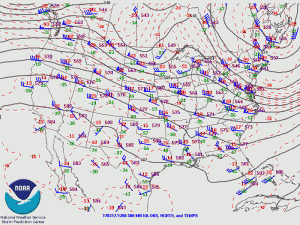
Another issue with the BSR in late February was the exact geographical placement of the meteorological features. The center of a ridge ended up being more than 400 miles west than forecast. Such a shift in location leads to significant forecast changes.
The BSR, when examined in late February, suggested the flat ridge currently over the Rocky Mountains to be more pronounced (what meteorologists refer to as more amplified) and further to the east, basically due north of New Orleans. This difference in the upper-level pattern would have made a huge difference at the surface across the country. Mild Pacific air, currently over the Rockies and the High Plains, would have warmed an even greater area over the Mississippi Valley region as it spread east and reached the mid-Atlantic and points south. Instead of a pattern of warm temperatures found only over portions of the West the warmth would have extended all the way to the Atlantic.
There is no doubt about it: in terms of the sensible weather for those in the Northeast and Mid-Atlantic, the BSR suggested a bad forecast. The overall upper-level pattern was off both geographically and chronologically which caused the surface forecast to go astray.
Looking forward into mid-April, Renken believes a troughy pattern in the Northeast which will cause the cooler than average temperatures to continue. “The trough will dominate the Northeast well into April. Often times, the chill will extend into the Mid-Atlantic to the south and the northeast part of the Ohio River Valley to the west. This looks to be the dominant upper-level pattern until early to mid-April.”
“The reason for this chilly weather pattern is a trough over the Kodiak Island region of Alaska will move southwestward and intensify over the next few days. This teleconnects to the same feature over Bangor, Maine… This is a chilly early spring pattern for many in the East with the chance of more snow for some.” Renken warns it’s too early to put the snow shovel away in parts of the northeast. “Upstate New York and interior portions of New England seem to be particularly at risk towards the end of the first week of April, somewhere in the time between the 5th and the 10th. The BSR suggests a clipper system to move southeastward from south-central Canada, into the Great Lakes and then off the New England coast where it may intensify.”

Further to the south and west, the mild pattern currently in place will be interrupted several times by chilly shots of Canadian air. As can be climatologically expected, the cold fronts ushering in these Canadian air masses will be accompanied by severe weather. The regions most at risk for severe thunderstorms will be the southern portions of both the Plains and the Mississippi River Valley eastward into the Deep South and the Southeast. Areas in the western part of this region carry the greatest severe weather risk. According to the BSR, the days with the greatest chance of severe weather would be around the 23rd and 24th of March, the 2nd through 4th of April, and then again later in April, around the 10th through 12th.