The National Weather Service in Honolulu, Hawaii released their Wet Season Outlook today: it appears the next several months will be very wet.
According to the outlook released by meteorologists there, a variety of factors should produce conditions that are more wet than usual during Hawaii’s wet season, which typically runs from October through April. NOAA’s Climate Prediction Center believes the current ENSO-neutral conditions are likely to continue through spring 2020. In the last 30 years, 8 out of the top 10 rainiest wet seasons have had ENSO neutral conditions. “ENSO” refers to the El Niño/Southern Oscillation, the interaction between the atmosphere and ocean in the tropical Pacific that results in a somewhat periodic variation between between below-normal and above-normal sea surface temperatures and dry and wet conditions over the course of a few years. While the tropical ocean affects the atmosphere above it, so too does the atmosphere influence the ocean below it. During ENSO neutral conditions, surface trade winds blow westward across the equatorial Pacific Ocean. Blowing against the ocean’s surface, these winds result in a westward current which have the potential to drive more moisture around the Aloha State. In addition to the ENSO forecast, a consensus of climate models favor above average rainfall through the wet season. According to the National Weather Service, the projected pattern suggests the possibility of cutoff low pressure systems that can produce intense rainfall, especially when combined with expected above average sea surface temperatures.

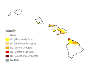
While a wetter than usual season could produce flood problems, it should also bring something beneficial to Hawaii: the National Weather Service says that the existing drought should be eliminated by the end of the wet season. According to the Drought Monitor update released today, there are extreme drought conditions in Maui County and on the northern Kohala Coast of Hawaii’s Big Island.
While Hawaii is exiting the dry season, it hasn’t been all that dry. According to the National Weather Service, this has been the seventh wettest dry season in the last 30 years based on rankings from 8 key sites. This contrasts to the 2015 dry season which was the wettest in the last 30 years and the 2003 dry season which was the driest in the last 30 years.
Earlier today, NOAA also released their winter outlook for the entire United States. It calls for a much higher chance of above normal temperatures and higher chance of above normal precipitation. Kevin Kodama, the Senior Service Hydrologist for the Honolulu office of the National Weather Service described some of the collaboration that occurs between their office and NOAA’s Climate Prediction Center that releases the national seasonal outlooks. “We’ll email each other. We want to stay consistent. Ultimately, it’s our forecast. However, we all want to play from the same sheet of music.”

Kodama said the active hurricane season that continues to the end of November isn’t a big factor in the upcoming wet season forecast. “Wet season is driven by wet season weather systems, like cold front, Kona Lows, and upper level lows; not necessarily tropical cyclones.” Earlier this year, the Central Pacific Hurricane Center called for 5-8 systems in the basin; pending final verification, the number stands at 5. Hurricane season in the Central Pacific runs until November 30, as it does in the Atlantic Basin.”
Something that’ll be absent from this wet season compared to previous ones is the lack of vog. Vog is volcanic-sourced haze that’ll fill the atmosphere with various aerosols. Not only did the Lower East Rift Zone eruption conclude last fall, but large quantities of volcanic emissions that have plagued Hawaii’s Big Island for years have also ceased. The lack of vog has led to more rain in places like Kona during the dry season that just wrapped-up and Kodama says the wetter weather will continue. “As long as volcanic activity remains quiet, I wouldn’t be surprised if wet conditions continued into next summer beyond boosting rainfall amounts in the upcoming winter storms.”

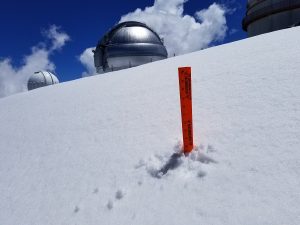
During the winter months, snow can also fall on the higher elevations of Hawaii and Maui islands. Kodama tells us with a wetter wet season forecast, more snow could fall too. “There’s definitely the potential for more snow, especially with the expectation that we’ll see more upper level low systems impacting the state.”
While dry season is ending on a wet note and wet season is expected to be even more wet, there’s still unusual weather occurring on Hawaii’s Big Island. “South Point has been very interesting this season, ” Kodama said. ” But there’s been a very localized area that’s been unusually dry. Ranchers makai of our rain gauge report rain, but not below. Vegetation health data from our satellites confirms the very dry conditions there.” Overall, the Ka’u District has seen a wet dry season. But even though this part of South Point has been unusually dry, so much so there was a large fire here earlier this month, Kodama believes the wet weather will return even there. “Over the next several months, they’ll get their grass growing back.”