The National Weather Service’s Storm Prediction Center (SPC) is warning that a fresh severe weather event is expected to unfold and spread east later this week into the weekend, exposing millions of people to threats from damaging wind gusts, large hail, and/or tornadic thunderstorms.
An intense spring storm system will deliver a multi-day severe weather episode to portions of the central and eastern U.S.
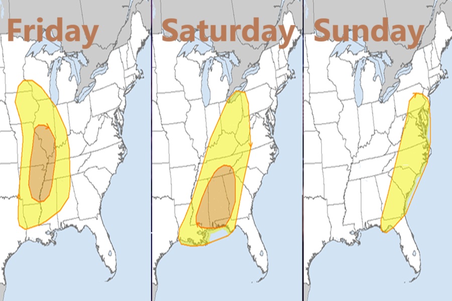
beginning Friday and continuing through the weekend. According to the SPC, all severe thunderstorm hazards are expected, including widespread damaging winds, tornadoes (some strong), and large hail.
On Friday, an anomalously intense upper cyclone is forecast to deepen as it tracks northeast across the southern/central Plains to the Upper Midwest. An intense jet streak will overspread the Ozarks and Mid-Mississippi Valley during the afternoon into the overnight hours. Likewise, a low-level jet will intensify Friday night. As intense surface cyclogenesis occurs, southerly low-level flow will transport modest moisture as far north as eastern Iowa, southeast Minnesota, and southern Wisconsin. Deeper boundary-layer moisture will remain focused southward from the Mid-South toward the Lower Mississippi Valley and central Gulf of America coast.
According to the SPC, strongly forced convection within intense deep-layer flow will pose a widespread risk for severe thunderstorm winds and tornadoes from late afternoon into the overnight hours across a large area centered on the Mid/Lower Mississippi Valley vicinity.
On Saturday, the upper cyclone over the Upper Midwest will lift northeast into Ontario, Canada, but a larger-scale upper trough will remain over the Plains. The Plains trough will intensify and spread east toward the Mississippi and Ohio Valleys. This will maintain the eastward progression of a strongly forced line of convection from the Ohio Valley south/southwest into the Deep South/central Gulf coast vicinity through Saturday night. Portions of the Deep South into Georgia may see multiple rounds of severe convection posing a concern for damaging tornadoes and swaths of severe winds.
On Sunday, the system will continue to shift east, with a moist airmass and strong deep-layer flow continuing to support a line of convection producing damaging winds into the Carolinas and Mid-Atlantic vicinity.
